Cycling Bellevue to Bear Lake, Idaho: Lava Landscapes and Bubbling Springs

25 July - Aug 4, 2021
Segment 4 of the Western Wildlands Bikepacking Route (341 mi, 549 km)
Check out our interactive route map to see where we stayed each night
Reflecting on Life on a Bike
We were nearly all packed up and ready to head out of Bellevue, Idaho, when one of our campground neighbors came over to chat. She sighed that she was a little bit envious of us because we were living life so simply, with few possessions.
She was in the process of moving, and downsizing her lifestyle. As a result, she has realized that she didn’t need as much stuff as she once had. It was liberating, she said. And she saw our travel as the ultimate version of simple living. Of course, bicycle travel is not for everyone - and many people cannot imagine attempting what we are doing. But there are whole lot of other people who tell us that it is their dream to do a long, self-supported bicycle tour someday. We shared good-byes, and pedaled on up the road.
Over the Pioneer Mountains
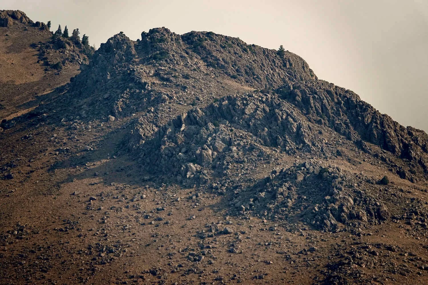
Of course the day, as with many, started off with a vigorous climb. The morning was cool, but it warmed up fast. And there was no relief from the sun in the treeless, sage-covered hills.
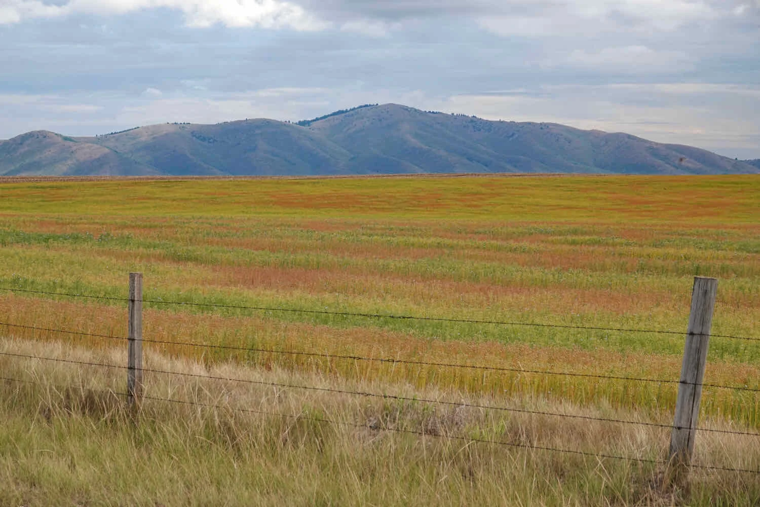
The big, open landscapes along the Western Wildlands Bikepacking Route can make you feel small. Today, there was no relief from the baking sun. Pioneer Mountains, Idaho, USA. Copyright © 2019-2021 Pedals and Puffins.
By the time we reached the summit, it was time for breakfast. So we set down our bikes and found a couple of rocks to use as chairs. We had to ask a tiny praying mantis, no more than 1.5 inches long, to give up its perch on one of the rocks for us. At first it resisted moving. But then it decided it would be better to get out of the way than to get squished, and flew away. We munched on a couple of energy bars while gazing out on the wild expanse of the Pioneer Mountains.
This itsy-bitsy praying mantis considered fighting us for the right to sit on this rock, but then changed its mind and flew away. Muldoon Pass, Pioneer Mountains, Idaho, USA. Copyright © 2019-2021 Pedals and Puffins.
Our view from breakfast at the top of Muldoon Pass, Pioneer Mountains, Idaho, USA. Copyright © 2019-2021 Pedals and Puffins.
As we headed down off of the pass, we came to a junction where several roads met, and veered off in different directions. It wasn’t clear which way we should go. PedalingGuy has done a fantastic job of navigating us through some very remote areas, but it’s not always easy. Sometimes the roads on our GPS map don’t match up that well with the backroads we find ourselves traveling on. We asked the local cows if they knew which road led to Craters of the Moon National Monument. But they didn’t seem to have a clue, as usual, and wandered off without providing any advice. We ended up taking the road that seemed most likely to match the map, and everything worked out fine.
These cows were no help when we needed to figure out which way to go at a particularly confusing junction of back roads. They just wandered off, without answering our questions. Pioneer Mountains, Idaho, USA. Copyright © 2019-2021 Pedals and Puffins.
For several miles we rode along the edge of a small canyon, with a cottonwood-lined stream below. It was an oasis of green in the parched, sagebrush landscape. Copyright © 2019-2021 Pedals and Puffins.
Into the Land of Ancient Volcanos
The descent down the far side of the pass took us out of the northern Rocky Mountains, and onto the vast Snake River Plain. Although the Snake River runs through it, this is not your typical floodplain created by erosion from a river. Instead, it formed as the North American tectonic plate has inched slowly to the southwest over a geothermal hotspot, which now lies under Yellowstone National Park. Over the millennia, volcanic eruptions broke through the earth’s surface where it crossed the hotspot, spewing cinders and lava. What remains is a 70-mile wide depression filled with volcanic rocks that vary from massive cinder cones to basins filled with gritty, sand-sized volcanic ash.
The road down the far side of the pass was very rutted and bumpy. Even once we hit the bigger gravel roads at lower elevations, the surfaces were covered in washboards that jolted us around. When we ultimately reached the highway that would take us towards Craters of the Moon National Monument, it felt smooth as silk.
Bouncing our way down the rocky, gravel roads. Pioneer Mountains, Idaho, USA. Copyright © 2019-2021 Pedals and Puffins.
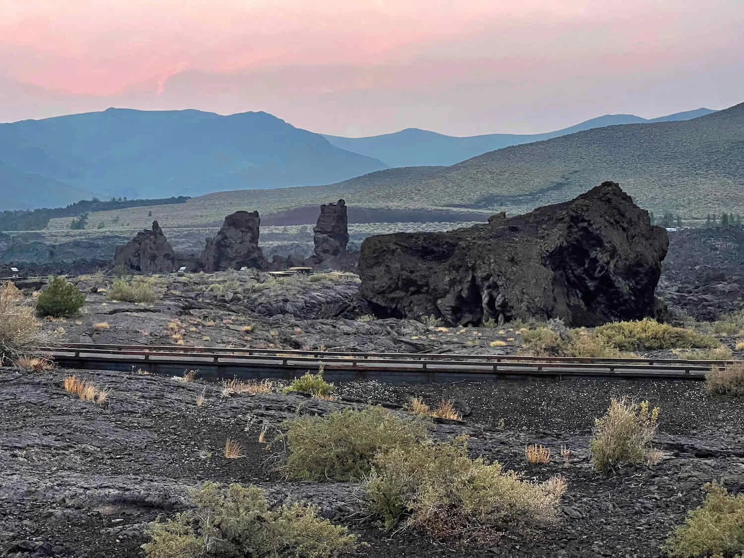
Rather abruptly, the sage-covered hills were replaced by a dark-colored, lava-rock landscape. We had reached a place where you can experience being on the moon, while still here on earth.
We’ve managed to cycle from the earth to the moon, as sagebrush hills were replaced by barren fields of lava rocks. Craters of the Moon National Monument, Idaho, USA. Copyright © 2019-2021 Pedals and Puffins.
We’ve arrived! Craters of the Moon National Monument, Idaho, USA. Copyright © 2019-2021 Pedals and Puffins.
When we arrived at the National Monument’s visitor center, we were both worn out from the 25 mph winds and the scorching heat. We headed straight for a vending machine selling cold drinks. You’re not allowed to take food or drink into the main center, so we sat on a bench in the shade, and slowly re-hydrated. Then we went back inside to watch the video about the park. Of course, we were fascinated by the video’s explanations of how these amazing lava-scapes were formed. But it was also wonderful to just sit and relax in the air conditioned room. We took some time in the afternoon to stake out a site in the park’s campground, but then went back to view the exhibits at the visitor center until closing time at 6pm.
Camping in a lava field. Craters of the Moon National Monument, Idaho, USA. Copyright © 2019-2021 Pedals and Puffins.
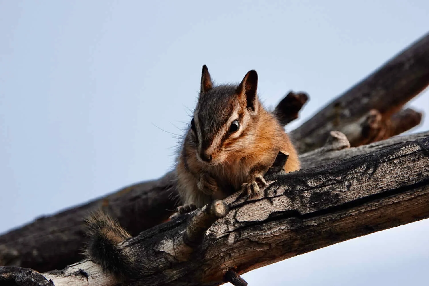
After dinner at our campsite, we went for a short walk at dusk to see some of the lava formations. Bears weren’t a concern, here, but we still had to be careful with our food. The local chipmunks were constantly checking in on campsites, hoping to find some unattended snacks. The worst thing about chipmunks isn’t the amount of food they might eat, but rather the hole they would make in your panniers when trying to get to the food.
The Atomic Town of Arco
After five consecutive days of camping, we decided to take a short-mileage day, and treat ourselves to a hotel in the town of Arco. We took our time, enjoying the scenery and wildlife along the quiet gravel roads of the WWR that led towards town.
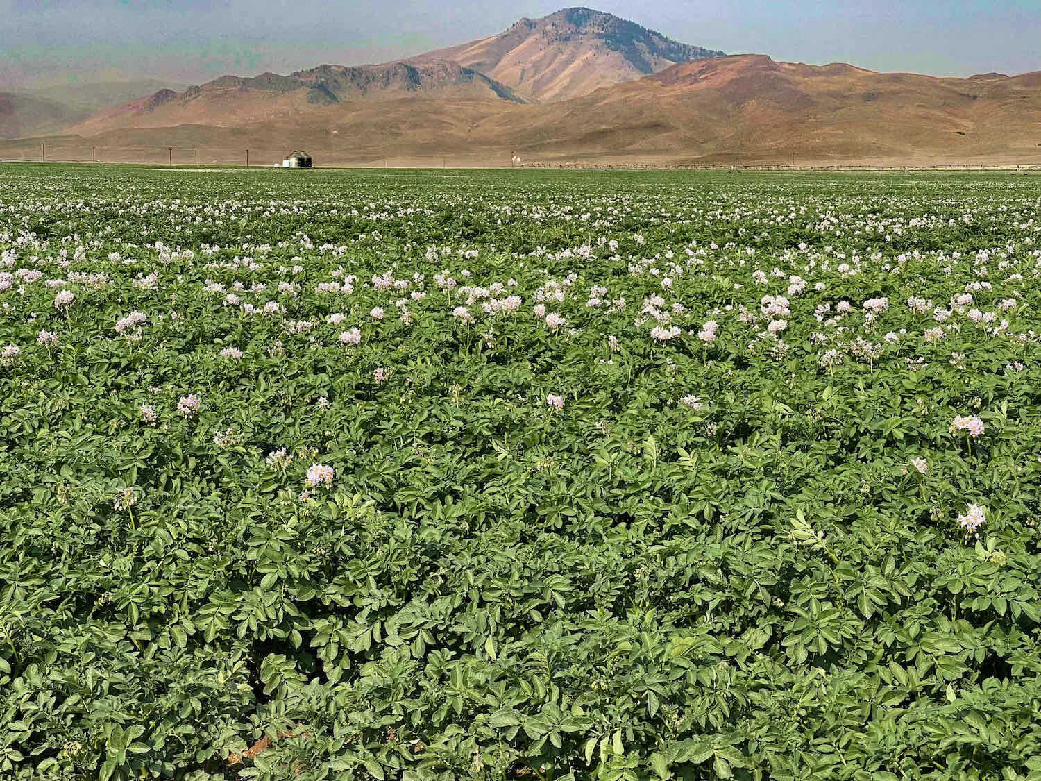
This region in southeastern Idaho is where they grow most of those famous Idaho potatoes. In fact, it is one of the most productive potato-growing regions in the world. We were not surprised to see large fields of potato plants - many of them in bloom.
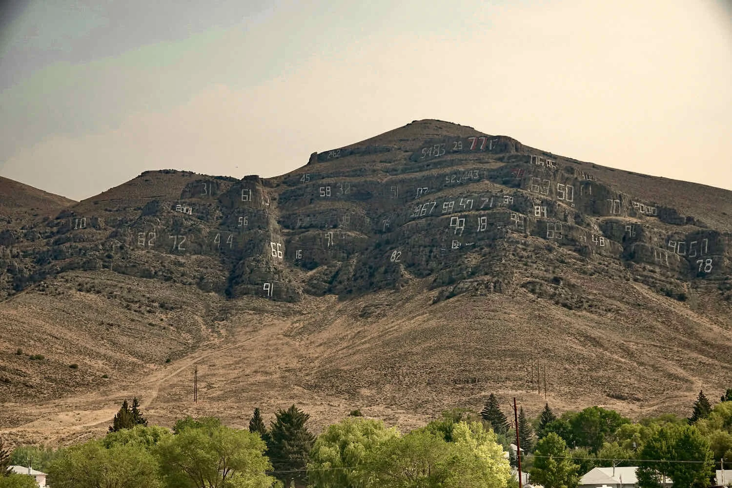
Looming over the town of Arco is the local landmark, Number Hill. You can’t miss it. Each year since 1920, members of the graduating class from the local high school risk life and limb to paint their class number in giant digits on the mountainside. In several storefronts in town, there were notices commemorating the 100th anniversary of this tradition, which happened in 2020.
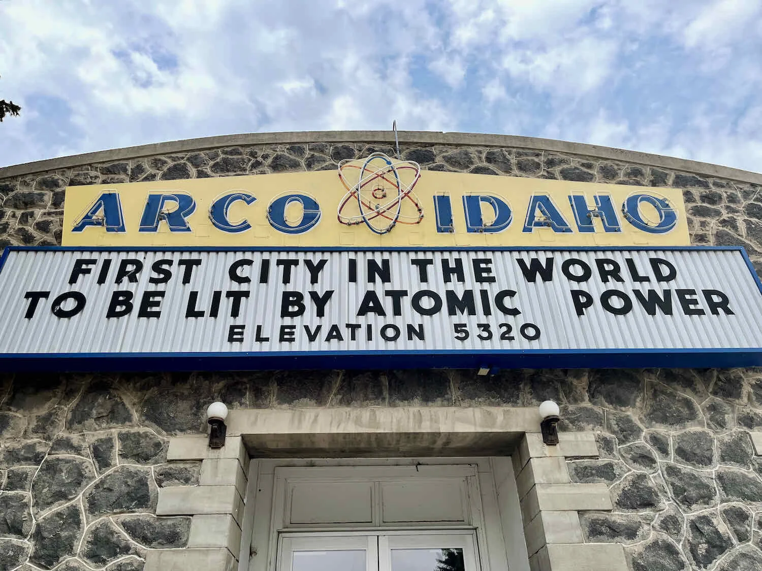
Arco’s other claim to fame is that it was the first city in the world to be lit by atomic power. This honor occurred because of the town’s proximity to the Idaho National Laboratory, where atomic energy experiments were conducted in the early days. So, for approximately two hours in 1955, Arco’s main energy supply was replaced with electricity produced from a nuclear reactor at the Lab. Luckily everything went according to plan, and the experiment was a success. Arco still basks in the glow of that event.
A Marathon Across the Arco Desert
The next leg of our journey was a tricky one. We had to cross 73 miles of the dry, exposed, and hot Arco Desert. Because there is no surface water, one is forced to either use water from cattle watering stations (which is very unappealing), or carry all the water you need to get across the desert. Water is heavy, so that option is also rather unappealing. But for us, it was better than sharing water with the cows. The desert is so formidable that the Big Lost River, which flows through Arco, disappears somewhere out on the plain as all of its water either evaporates away or sinks into the sand. It’s a harsh place.
We debated whether to break the ride up with a night of camping out in the desert. But that would require carrying even more water to make it through the night. We decided that since there wouldn’t be any major mountain passes to climb, we’d forge ahead and try to cover all 73 miles in one day. It would be a marathon, for sure.
We set our alarm for 4:30 in the morning, hoping to get a pre-dawn start that would provide for more riding in the cool morning air. But it seemed like the forces of nature were against us. After eating some breakfast, PedalingGal didn’t feel well at all. She was shivering, and had an upset stomach.
Then the second shoe dropped, so to speak. When we had arrived in Arco the day before and checked into a hotel, we discovered that the air conditioning didn’t work in the only room they had available. So we ended up moving to a different hotel. Now, PedalingGuy realized that he’d left his biking shoes behind at the first hotel. He had placed them under the bed, and didn’t see them when packing up. We would have to wait for their office to open later in the morning, so he could go retrieve his shoes. Clearly we were not going to get such an early start.
We both went back to bed. A bit later, PedalingGal stayed in bed while PedalingGuy went over to the first hotel to wait for the office to open. Once they did, he luckily was able to get his shoes back.
By now it was around 7:30am. But would PedalingGal be up for a big ride? She wasn’t sure, but decided to make a go of it. Staying in Arco another day just wasn’t that appealing. Plus, we had a reservation for that night at a hotel in Blackfoot on the other side of the desert. Perhaps getting some blood flowing would help.
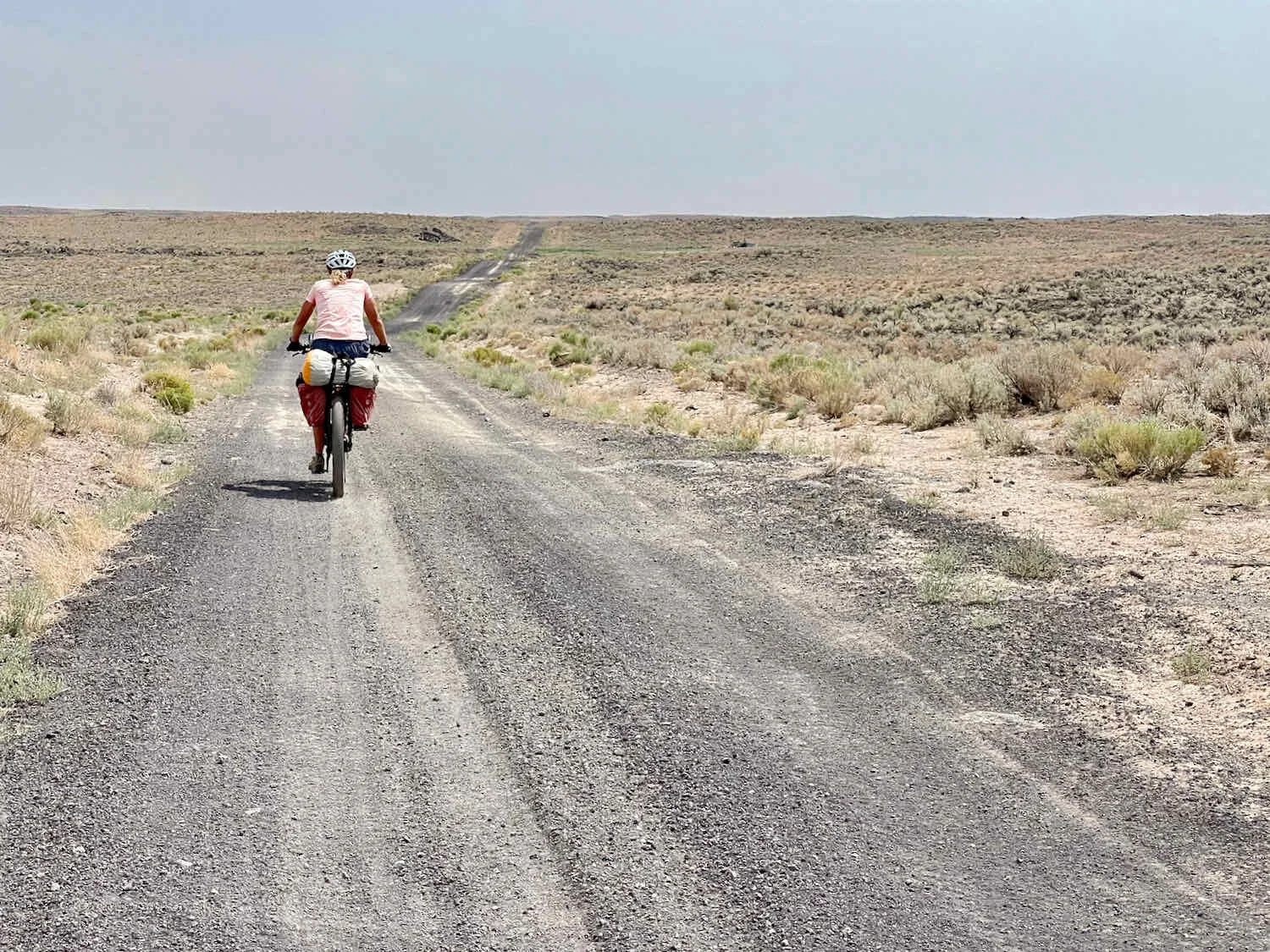
The entire ride wound its way through open, sagebrush country with rolling hills. There was absolutely no shade, anywhere.
A lone bike rider is just a small speck in the Arco Desert. Snake River Plain, Idaho, USA. Copyright © 2019-2021 Pedals and Puffins.
Among the endless rolling hills of brown and muted green, there was one prominent feature called Big Southern Butte - a very large mountain that looms over the plain, all by itself. According to the signs, it’s one of the largest and youngest volcanic domes in the world, rising 2,500 vertical feet from the plain with no foothills or gentle slopes.
Big Southern Butte is definitely big. It’s all the more impressive because of the way it just rises, all by itself, out of the Snake River Plain. Arco Desert, Idaho, USA. Copyright © 2019-2021 Pedals and Puffins.
We did not see a single vehicle on the road once we left the private lands around Arco. There were a few cows, fences, and an occasional cattle trough, but no other signs of people. It was quite desolate. The area felt even more remote than the Magruder Corridor which passes between two of the largest wilderness areas in the United States. We were the only ones crazy enough to be out on this road.
The afternoon sun was oppressive. Each time we stopped for any reason between 11am-5pm, the heat beat us down. We had a small lunch while sitting on some rocks beside the road. As we ate, our snack bars were melting in our hands. And we were melting as well. The water in our bottles became hot - not very pleasant, and certainly not refreshing.
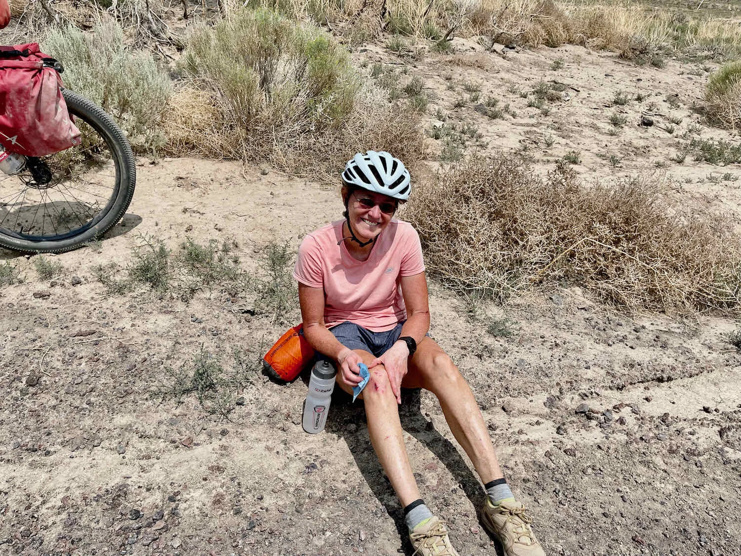
The surface on the backroads of the Arco Desert was surprisingly diverse, with gravel of various sizes mixed with loose, fluffy ash, and occasional rocky patches. The toughest section included a couple miles of deep, shifting, orange-colored sand that covered the road and was impossible to cycle on. We abandoned the road and cycled across the desert instead, which was slow going. There were also dozens of miles of treacherous, loose gravel, with some deep patches on small, steep slopes. On one particularly slippery downhill, PedalingGal hit the gravel again - scuffing up the same knee she’d scratched a couple of weeks ago.
The final 10 miles into Blackfoot saw the gradual return of civilization. There were many acres of irrigated, cultivated fields, fed by the waters of the Snake River.
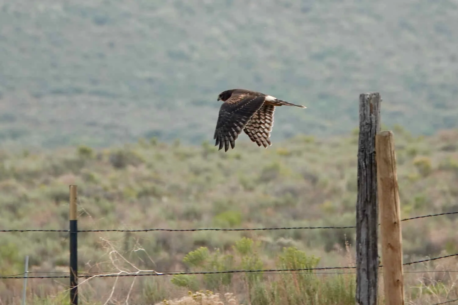
We saw quite a bit more wildlife in the agricultural areas near the Snake River, including lots of hawks hunting over the fields. Blackfoot, Idaho, USA. Copyright © 2019-2021 Pedals and Puffins.
In the end, our late start probably wasn’t such a big deal. We would have had to cycle through the hottest part of the day even if we had started a couple of hours earlier. And by the time we reached Blackfoot, the evening had started to cool down again. We were fortunate that everything worked out for the best.
We took a few days off in the relatively large city of Blackfoot, to replenish our supplies and take care of some bike maintenance. Our disc brakes had been getting squishy, so we had new brake pads delivered to our hotel, where we performed some in-room repairs. The old pads probably still had some life in them, but we really depend on those brakes to keep our loaded bikes under control on some pretty tricky descents. The fresh pads gave us a lot more grip, and set us up for the next leg of the trip.
The new brake pads popped right in, just like they were supposed to. Blackfoot, Idaho, USA. Copyright © 2019-2021 Pedals and Puffins.
And who wouldn’t want to visit the Idaho Potato Museum? In Idaho’s potato-growing heartland, the museum celebrates the history and uses of this hard-working vegetable. We particularly enjoyed some of the exhibits related to how potatoes are planted and harvested.
Two potato fans. Blackfoot, Idaho, USA. Copyright © 2019-2021 Pedals and Puffins.
There Are No Easy Days
After climbing through the high passes of the northern Rocky Mountains, and battling our way across the long-mileage of the Arco Desert, we were looking forward to some days when the cycling might be less taxing. After all, the WWR website classifies this section of the route as having a physical difficulty of 4 - as opposed to the 6’s and 7’s of previous segments. That sounded like a welcome break.
But there are few things about riding the WWR that are easy. Every day brings new challenges. If you’re not climbing a big mountain pass, there still will be some other factor - the heat, the road surface, or the terrain - which will push you to your limits and make you work for almost every mile.
On our way out of Blackfoot, we had a nice surprise. The pavement lasted almost 25 miles - quite a bit longer than expected. That helped us make a fast start, and perhaps made us a little over-confident about the rest of the day’s ride. Our early speed turned out to be really important because the second half of the day was extremely difficult and slow.
We carried all the water we would need for two days of riding - about 19 L in total. That turned out to be a good idea. Although the information provided for the WWR says there are water sources along this stretch of the route (including creeks and the Blackfoot River), none of them were appealing. There were cows everywhere, and they had access to all of the water. Also, the Blackfoot River had foam in it - maybe from fertilizer? Anyway, we were really glad that we didn’t have to drink any of that water, even if we could have filtered it.
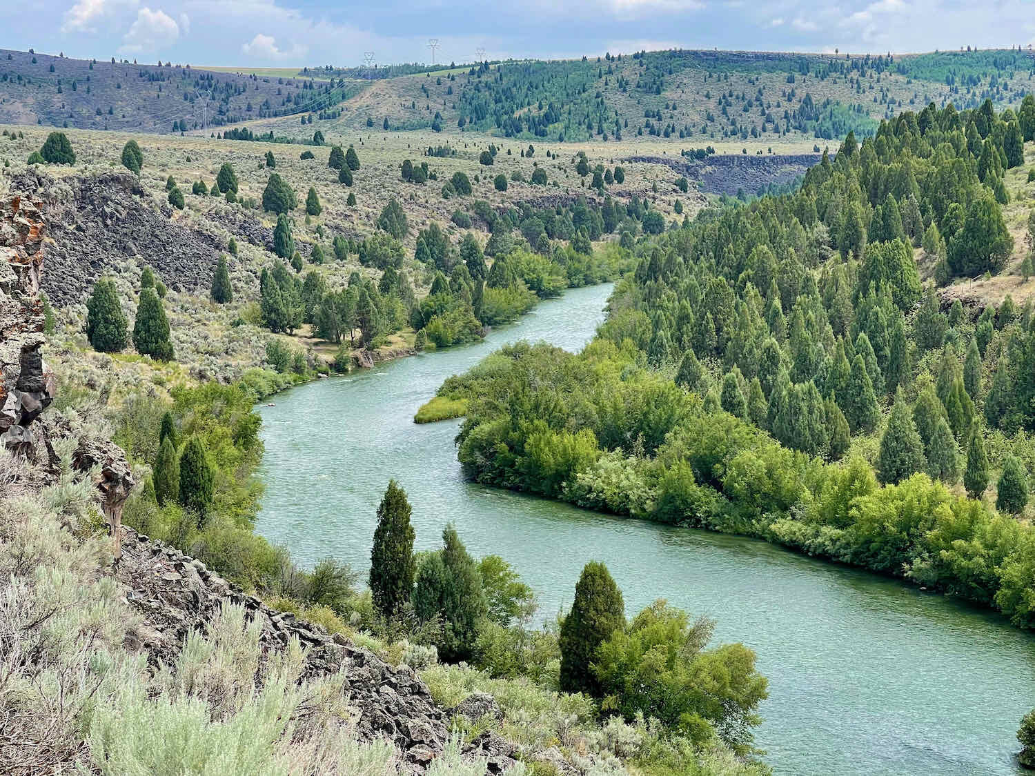
The ride was surprisingly scenic. Here, the Blackfoot River cuts a deep ravine through the otherwise endless, sage-covered hills of the Caribou Mountains. Carved into the dark basalt rock, the picturesque canyon is lined with aspen and conifer trees. We soaked up the views from the top of the plateau, with the sound of rushing water playing constantly in the background.
But the lack of big mountain passes did not translate into easy cycling. From what we could guess, the road had recently been resurfaced with loose, chunky gravel that had not yet been packed down by cars. So, for most of the day we found ourselves slogging through deep piles of gravel that were especially slippery on the downhills. To make things even more interesting, the soil underneath was soft and squishy from recent, heavy rain. All this made pedaling a lot more taxing than it would have been on a hard-packed surface.
Then there were the hills. They were endless and very, very steep - often exceeding 12% grades. Some were quite long and too steep to ride up. We exhausted ourselves pedaling and pushing up the hills.
Unfortunately, a bit of human error occurred as well. We missed a turn about 37.5 miles into the ride, and went 3 miles out of our way - including a climb up a huge and steep hill. It was a real bummer to have to turn around and retrace our path.
But wait… as we were retuning to the missed turn, a rumbling thunderstorm bore down on us. With lightning crackling a little too close for comfort, we arrived at a campground at the bottom of the Blackfoot River canyon. It was decision time - do we keep going, or hunker down? Looking around, there wasn’t really anywhere at the campground to get out of the weather. We actually considered whether we should climb under one of the picnic tables for shelter from the lighting. Yet, as we were debating our options, the storm seemed to ease up a bit. It had not yet started raining.
We made the decision to keep going. But on the slow, steep climb out of the canyon, the wind whipped up again and big raindrops started to fall. We dove for cover next to an aspen grove about halfway up the canyon wall.
But, of course, once we got out our rain coats, the storm started to dissipate again. And pretty soon we were back on the road. Dark clouds and periodic raindrops threatened for the rest of the ride, but we managed to escape any substantial rain. We tried to “outrun” the storm, but PedalingGal’s legs were mush, and she emphatically let PedalingGuy know that she wasn’t going to be able to outrun anything. Luckily, the storms just threatened us with lots of swirling wind, a little rain and some lighting. We just missed the worst of it that we could see in the distance.
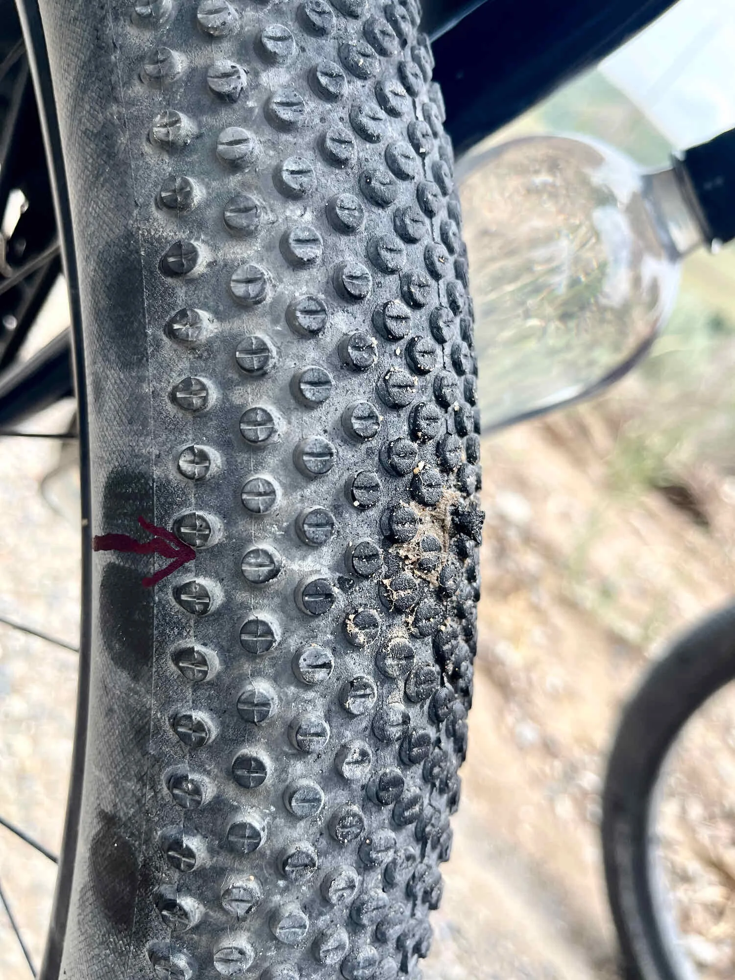
Adding a little more spice at the end of the day, PedalingGuy got a puncture in his tubeless tire that the sealant couldn’t seal. The hole wasn’t very big, and at first it seemed as though the sealant would do the job of closing it up. But each time he started riding, the hole would open up and hiss sealant again. We used a Dynaplug to fix it, and that sealed it right up. We had to admit the Dynaplug was way easier than changing out an inner tube after a flat. The whole process of plugging the hole took less than a minute. We carry a Sharpie marker to mark all problem areas on a tire (to more easily find the weak spot in the future). Sometimes it is important to be able to tell if you are repeatedly having a problem with the same puncture on a tire, or a new puncture.
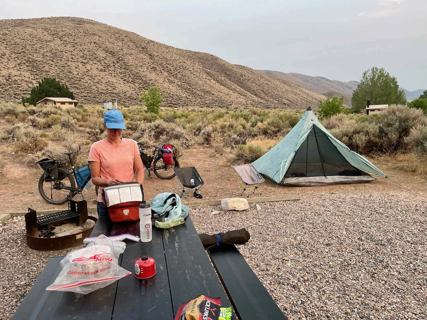
We arrived at Graves Creek Campground, a Bureau of Land Management (BLM) facility right next to the Blackfoot River, totally worn out.
We ended the evening by going to sit by the river, with intermittent light rain falling. The camping area was typical BLM. Nothing fancy, just a few picnic tables, fire pits and an outhouse in a meadow. But the scenery was really beautiful in the canyon, next to the Blackfoot River. We were the only ones in the campground and it was a relaxing way to end the day.
Chilling out by the Blackfoot River. Graves Creek Campground, Idaho, USA. Copyright © 2019-2021 Pedals and Puffins.
Critters in the Grass
When our alarm went of at 6am, we could hear rain on the tent. So instead of getting up and going, we snuggled down into our sleeping bags and got an extra half hour of sleep.
After packing up most of our stuff, we decided to have a leisurely breakfast to allow the tent to dry out. So far on this trip we’ve opted to get on the road quickly each morning, by having just an energy bar for breakfast (or skipping breakfast all together). But we had just bought a couple of freeze dried breakfast meals in Blackfoot (scrambled eggs and veggies), and decided this was the morning to give them a try. They were surprisingly good. And by the time we had finished eating, the tent was dry.
A couple of hours into the ride, we started to get into more cultivated lands, where the sagebrush was replaced by fields of grass. We were delighted to spot a family of three foxes out in a field. They were very shy, but curious enough to turn around and have a look at us after scampering off to a safe distance.
It’s not everyday that these foxes see loaded up bicycles lumbering through their territory. It was worth a second look, once they’d run off to a safe distance. Near Blackfoot Reservoir, Idaho, USA. Copyright © 2019-2021 Pedals and Puffins.
By mid morning, there was a big, black storm cloud building to the north. Later in the day there were also storms off to both our left and right. But somehow we managed to outpace the rain all day.
Storm clouds haunted us all day, sometimes surrounding us on three sides. But we somehow managed to stay dry. Copyright © 2019-2021 Pedals and Puffins.
Then, about 15 miles into the ride we missed another turn. To be honest, the road that the WWR turned onto was a barely-used two-track, paved with orange-tinted, lava rocks. We didn’t even consider the thought that our path would go that way. It was too much fun riding on the main gravel road.
We had gone about 1/2 mile in the wrong direction when we spotted a massive badger hole right in the side of the gravel road. We stopped for a photo of the badger den, then were thrilled to see an actual badger in the distance, ambling down the road towards us. He headed our way until he noticed us, then veered off into the sagebrush. PedalingGuy ran off into the sagebrush taking an angle that would intersect with the path of the badger. The strategy worked and PedalingGuy was able to get surprisingly close to this elusive animal. He got some very good photos, so the detour was worth it.

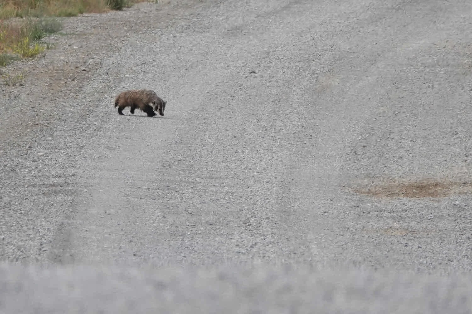
The face of an annoyed badger, waiting for these interlopers on bicycles to go away. Near Blackfoot Reservoir, Idaho, USA. Copyright © 2019-2021 Pedals and Puffins.
After visiting with the badger, we turned back to continue riding on the official WWR route. In reality, we probably should have just stayed on the main gravel road. It must have been easier to ride on than the WWR route, and we would have reconnected with the WWR route after about nine more miles, anyway.
But, no. We took the WWR route. So instead of riding on a well-groomed gravel road, we found ourselves clawing our way through nine miles of leg-achingly steep hills on a nasty lava surface. The road surface here was very difficult to ride on - soft, sandy grit littered with jagged, golf-ball sized lava rocks. It seemed like we were going to tear our tires apart - but thankfully they survived.
Then, something wonderful happened. At about 27 miles into the ride, we hit a quiet, peaceful, paved road (about 7 miles sooner than expected). We stayed on the pavement and enjoyed a bump-free ride for the rest of the day.
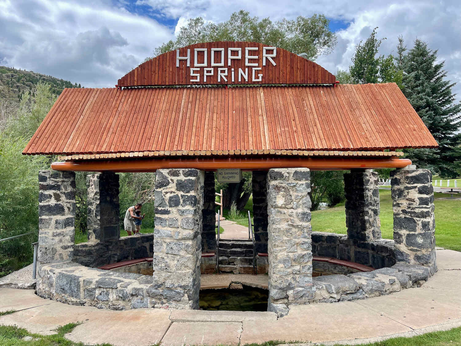
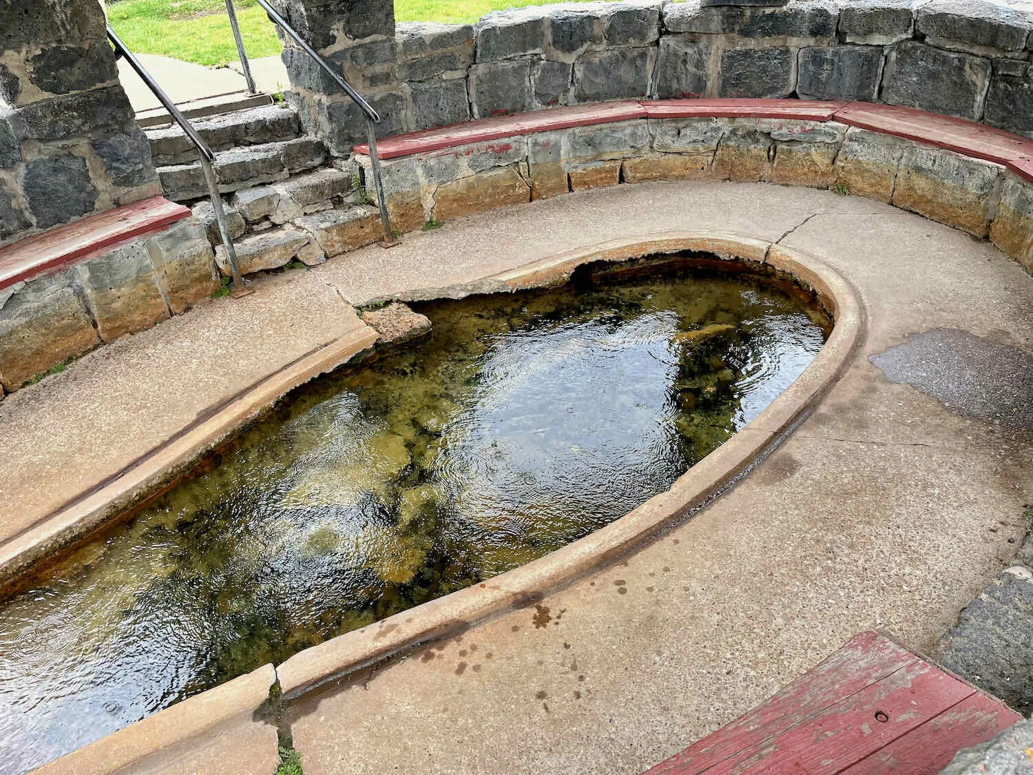
As we approached Soda Springs from the north, our route took us right past Hooper Spring - one of the “soda springs” that give the area its name. Known to the travelers on the Oregon Trail as Beer Spring, the water emerges from the ground fizzing with bubbles from a natural carbonation process. We stopped to have a look, and marvel at the bubbly water emerging into the Spring House. But, although the water here is potable, we didn’t have a drink. Neither one of us is particularly fond of plain soda water.
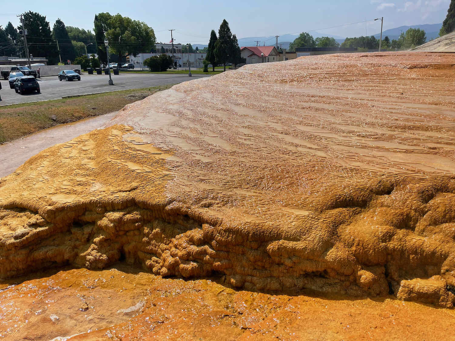
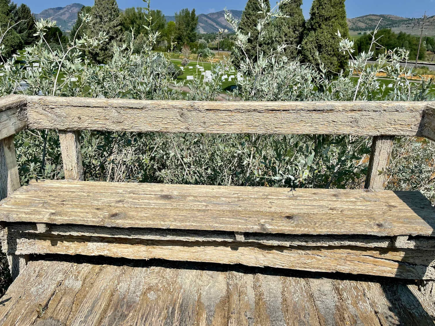
From Hooper Spring the WWR route ambles along a gravel bike path that parallels Soda Creek all the way into town. We arrived in Soda Springs just in time to see the geyser erupt. The city has regulated the pressure of the carbonated water in the spring so that it “erupts” every hour, on the hour. The mineral deposits from the geyser have formed a dome of bright orange travertine (iron and calcium carbonate), which is pretty impressive to see. And various wooden structures built around the geyser (like a boardwalk and benches) were all crusted with mineral deposits from the water’s spray. When the wood eventually rots away, they’re likely to have a bunch of travertine benches left behind.
Ta-da! The Soda Springs geyser erupted just as we entered town. Soda Springs, Idaho, USA. Copyright © 2019-2021 Pedals and Puffins.
Back on the Oregon Trail
In the morning, we were still a bit fatigued, so we decided to bike the first 18 miles by staying on Hwy 30, instead of taking the gravel roads recommended for the WWR route. We agreed that we would stop at the town park in Georgetown, and decide then whether to take the difficult route up Georgetown Canyon and across the Preuss Mountains, or stick with the highway.
Right on the edge of town we were reminded that we were back on the Oregon Trail - the famed overland route used by pioneers heading west. We’ve spent quite a bit of time cycling on sections of the trail, especially when we rode from east-to-west on the TransAmerica Route a couple of years ago.
The abundant water around Soda Springs was a welcome respite for westbound pioneers, after crossing the arid lands of Kansas and Wyoming. Soda Springs, Idaho, USA. Copyright © 2019-2021 Pedals and Puffins.
The ride on Hwy 30 from Soda Springs to Georgetown was a breeze. There was a wide shoulder, and traffic was fairly light most of the morning. We stopped to read roadside history signs a couple of times. The valley was covered with agricultural fields of alfalfa and barley, hemmed in by sage-covered hills. The mountains in the background were pretty dim, though, because of a thick haze in the air.
And we thought we were moving slowly… Roadside sign near Soda Springs, Idaho, USA. Copyright © 2019-2021 Pedals and Puffins.
When we arrived in Georgetown, we bought a couple of drinks from the single vending machine at the town park, then went to a covered pavilion with picnic tables to consider our options.
It was a pretty easy decision. Our legs were still tired from previous days’ riding, and we knew that potable water would be very scarce in the mountains. So we opted to continue on the highway.
It’s quite a surprise to come upon Bear Lake, a huge, freshwater lake plopped down in the middle of this immense and barren landscape. Early people in the area must surely have thought they were seeing a mirage. These days, the lake is a magnet for inlanders seeking a chance to play in the water.
When we reached the northern end of Bear Lake, we were startled to see how crowded the beach was. Even on a Wednesday, the area was packed with cars, people and their beach gear (e.g., canopy tents). And the water was swarmed with small boats and jet skis. We started to worry about whether we’d be able to get a campsite up the road.
Along the lakeshore drive, we passed a dozen small developments, with private homes. Many of them looked quite big and expensive. This is clearly a desirable vacation spot.
Arriving at the entrance to the campground, we were distressed to see a sign announcing that it was full. But we didn’t have many options, so we called the phone number for a ranger that was posted on the (unoccupied) entrance station.
After a couple of tries, we connected with a very nice ranger who seemed eager to help us out. He said there had been a couple of cancellations, and gave us the numbers of three campsites to choose from. We were elated.
No room at the campground - unless you’re willing to make a few phone calls. A ranger told us there had been some cancellations, so we were able to snag a campsite for the night. Copyright © 2019-2021 Pedals and Puffins.
In spite of the fact that Bear Lake State Park seems to have gone to extra effort to make sure none of its campsites have any shade, we were able to get a campsite that had some bushes next to it.
Unfortunately the bushes were dropping ripe berries that left stains on anything they touched, so we didn’t want to put up the tent underneath them. But we were able to set up our folding chairs and enjoy some shade until the evening started to cool down.
Hiding out from the sun under some berry bushes. East Beach Campground Bear Lake State Park, Idaho, USA. Copyright © 2019-2021 Pedals and Puffins.
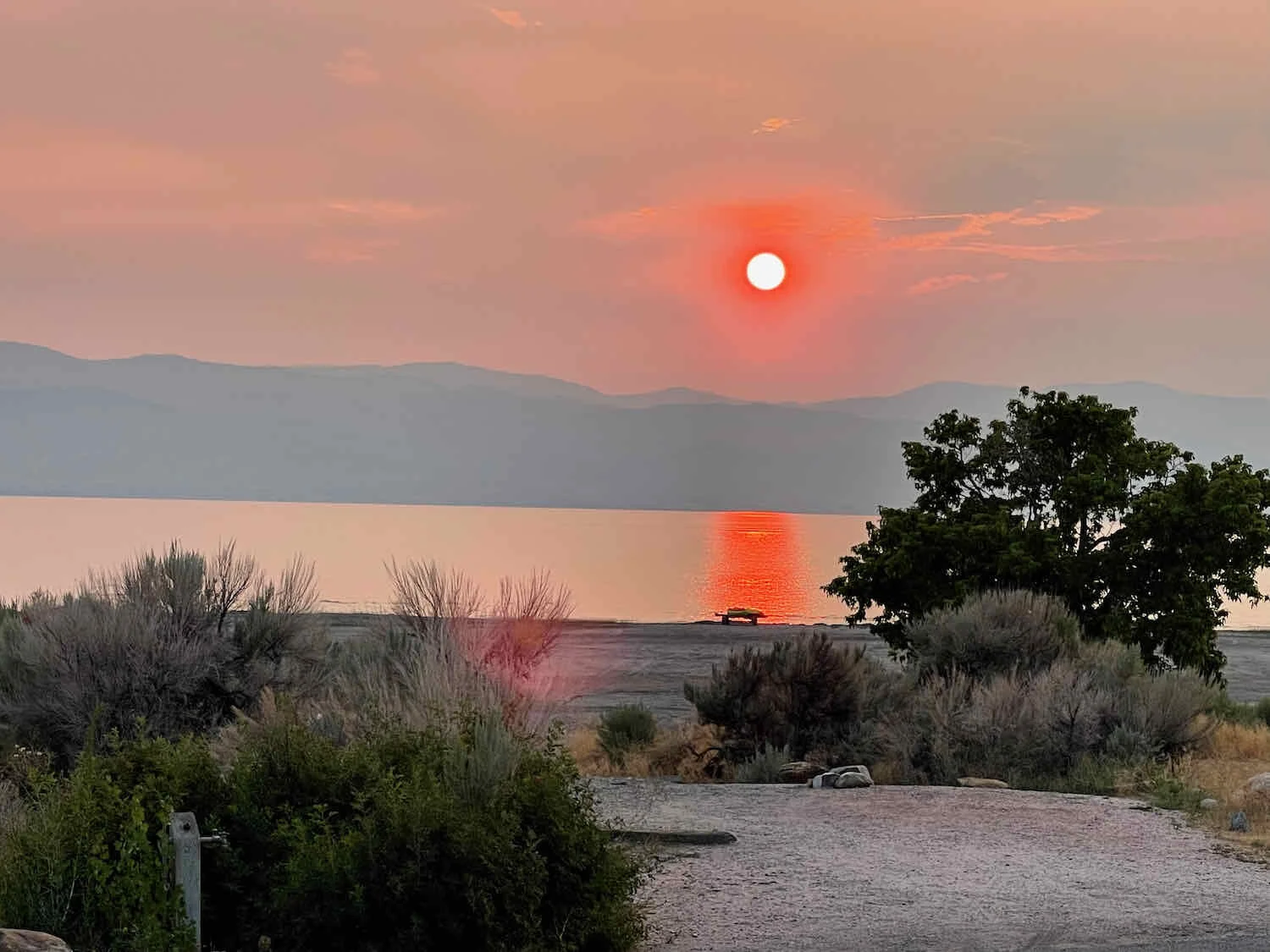
Late in the evening, as the sun was about to set, we finally stirred from our hideaway to pitch our tent and have dinner. The smoke from forest fires, which seems to be following us wherever we go, settled over the lake and turned the sunset bright orange.
Tomorrow we leave Idaho behind, and head southward into Utah.