Cycling the Pan-American Highway in Ecuador, Part 1: Cuenca to Quito
12 April - 30 May 2026
12 April - Cuenca to Biblián (23.7 mi, 38..1 km)
13 April - Biblián to El Tambo (23.6 mi, 38.0 km)
14-15 April - Rest and Rain Days in El Tambo
16 April - El Tambo to Chunchi (37.9 mi, 61.0 km)
17 April - Rest Day in Chunchi
18 April - Chunchi to Alausí (22.0 mi, 35.4 km)
19 April - Alausí to Riobamba (via car)
20-25 April - Mechanical Layover in Riobamba
26 April - Riobamba to Ambato (32.8 mi, 52.8 km)
27 April - Rest day in Ambato
28 April - Ambato to Latacunga (27.5 mi, 44.3 km)
29 April - Latacunga to Anita Lucía de Quisinche (29.1 mi, 46.8 km)
30 April - Anita Lucía de Quisinche to Valle de los Chillos (26.6 mi, 42.8 km)
1 May - Rest day in Valle de los Chillos
2 May - Valle de los Chillos to Quito (12.0 mi, 19.3 km)
3-30 May - Layover in Quito
The Land of Eternal Spring
From Cuenca to Quito, our route headed northward on the Pan-American Highway, following the long, high, narrow valley that separates the two main spines of the Andes. Formed millions of years ago by glacial rivers flowing through layers of volcanic ash, the valley offers the path of least resistance through the high sierras. Its fertile floodplains and ancient lake beds contain the most attractive lands for human settlement within the otherwise challenging, alpine landscape. As a result, three of Ecuador’s top five metropolitan areas are found nestled within this corridor.
Yet despite millions of years of erosion, the valley remains quite lofty - rarely dipping below 7,000 ft in elevation (2,135 m), and frequently reaching nearly 12,000 ft (3,650 m) to launch over high passes. So although Ecuador straddles the equator - theoretically the hottest zone on the planet - the inter-Andean valley remains pleasantly temperate year round. No wonder the valley is known as the Land of Eternal Spring.
It’s All About the Mountains
However, the only way to get such a pleasant temperature so close to the equator is to be high in the mountains. And mountains mean a lot of climbing when traveling by bicycle, even if you are in a supposed valley.
Although the inter-Andean valley has mellower terrain than the surrounding mountains, it is by no means flat. In fact, the slopes on which humans eke out a living were so steep that we were frequently amazed that there were so many people living there. Lots of the buildings seemed as if they were barely hanging on to a precipitous slope, farm plots looked far too steep, and the road served up an endless parade of lung-busting hills that alternated between roller-coaster descents and grinding, low-gear climbs lasting hours. The highlands of Ecuador were all about the mountains.
Our first destination out of Cuenca was the small town of Biblián (pop. 5,750) which rose up from the side of the Pan-American Highway onto the lower slopes of a mountain. People say that the surrounding hills are reminiscent of the Swiss countryside, with dairy farms renowned for their cheese, yogurt and dulce de leche. Of course, that meant that the final 150 m of our ride involved an additional 100 ft of ascent to the town. The neighborhood dogs had fun chasing and barking at us as we crept slowly up that last, little bit of road.
This weather-beaten, old house and miniature market added some character to the scenery as we hauled ourselves up the last bit of road into town. Biblián, Cañar Povince, Ecuador. Copyright © 2019-2026 Pedals and Puffins.
Perhaps the most notable landmark in Biblián was the gothic Virgin of El Rocio Sanctuary, built directly into a forested hillside overlooking town. The image of the Virgin inside is credited with several miracles, including the provision of rain to end a severe drought, and even bringing an end to Ecuador’s 1896 civil war. Biblián, Cañar Povince, Ecuador. Copyright © 2019-2026 Pedals and Puffins.
The hotel where we stayed ended up being one of the tallest buildings in town. The first two stories of the building were occupied by a gym, but the remaining 5-6 floors were all part of the hotel. It seemed like a really big hotel for a town of its size. Since there was no elevator, and our room was up four stories of narrow stairs, hauling our bikes up to our room was a challenge. Biblián, Cañar Povince, Ecuador. Copyright © 2019-2026 Pedals and Puffins.
Staying One Step Ahead of the Rain
There is a reason that Ecuador’s landscape is so lush and green - it rains A LOT. Ecuador’s rainy season typically lasts nine months, from September through May. During those months, you can pretty much count on rain every day. In response, long distance cyclists often try to time their crossing of Ecuador during the short, three month dry season (June through August).
However, our timing was a bit off. We were crossing Ecuador from mid-March through May, solidly within the country’s rainy season. Dirt-road bicycle travel in Ecuador during these months is strongly discouraged due to slippery, muddy conditions. That was one reason we decided to stick to the Pan-American Highway.
Yet we still had to contend with the daily rain showers - primarily by trying to do most of our cycling during the mornings. On most days the rain would begin around 1pm-2pm in the afternoon. So if we could reach our destination before then, we had a fighting chance of staying reasonably dry.
If one excuse for short days wasn’t enough, we also had another: there were lots of steep mountains. It’s always nice to line up multiple excuses, so that you don’t have to run and hide when you cross paths with one of those former cyclists who tells you about the 12-hour rides they used to do in their 20’s, while living off a couple of sandwiches a day.
We had arrived in Biblián right around noon. And as soon as we were settled in our room, a blustery windstorm blew through town. It dumped quite a bit of rain during a short period of time. We were glad we had made it indoors.
Over a High Pass to Tambo
We weren’t so lucky with the weather the next day. The ride involved a long climb over a high mountain pass which topped out at 11,500 ft (3,500 m), and it seemed like we spent the entire day cycling in the clouds. That meant it stayed overcast and cool throughout the big climb, which was ideal. However, we also rode through intermittent rain showers. We wore our raincoats most of the day.
Unfortunately, climbing mountains wearing a raincoat doesn’t really keep you dry. The raincoat just allows you to decide how you want to get wet. If you don’t wear it, you get wet from the rain. If you do wear it, you get wet from the sweat trapped inside. Needless to say, we got soaked.
Throughout the long climb we had sweeping views where it was hard to really comprehend the scale of of the distances across massive valleys. But one thing that stood out was how populated the landscape was. The hillsides were covered with numerous small communities marked by clusters of houses. And every inch between the houses was converted to cow pastures, crops (mostly corn and potatoes), or planted with non-native eucalyptus trees. The only places with natural vegetation were on the highest, most inaccessible slopes.
Throughout our ride under an overcast sky, we were surrounded by rolling hills covered with farms and pastures. N of Biblián, Pan-American Highway, Cañar Province, Ecuador. Copyright © 2019-2026 Pedals and Puffins.
Wherever the land was flat enough to farm there were fields of potatoes (like this one), or corn. Near Aguarongo Chico, Pan-American Highway, Cañar Province, Ecuador. Copyright © 2019-2026 Pedals and Puffins.
This roadside snack stand was called “the bus stop of flavor” (Parada del Sabor). Near Huandu Lake, Pan-American Highway, Cañar Province, Ecuador. Copyright © 2019-2026 Pedals and Puffins.
We were definitely cycling through dairy country. Any land too steep to farm was full of lush grass being grazed by cows. (Note PedalingGal’s rain coat - a futile attempt to stay dry as we cycled through the mist.) Near Mosquera, Pan-American Highway, Cañar Province, Ecuador. Copyright © 2019-2026 Pedals and Puffins.
This calf looked at us with mild curiosity. Like many places in South America, instead of using fences to keep cattle from wandering into the road, cows like this one were tied by a rope to a stake in the ground. Near Mosquera, Pan-American Highway, Cañar Province, Ecuador. Copyright © 2019-2026 Pedals and Puffins.
The distances across the valleys were so huge it was hard to comprehend their enormous size (unless you had already cycled up them). The far side of the valley was many miles away. Aguarongo Chico, Pan-American Highway, Cañar Province, Ecuador. Copyright © 2019-2026 Pedals and Puffins.
After 4.5 hours of cycling uphill, we stopped for a break at a simple bus shelter. A big drink and a moment to rest our legs gave us the energy to make it to the top of the pass. Near Inganilla, Pan-American Highway, Cañar Province, Ecuador. Copyright © 2019-2026 Pedals and Puffins.
After a huge downhill run coming off the top of the pass, we found the town of El Tambo (pop. 5,200) enveloped in a chilly mist. The fog was so thick it almost obscured the top of the bell tower on the central church. We were glad to shed our wet clothes, and have a dry place to spend the night.
The fog created a dreamlike, soft-focus for the bell tower of the St. John the Baptist Church on the town’s central plaza. El Tambo, Pan-American Highway, Cañar Province, Ecuador. Copyright © 2019-2026 Pedals and Puffins.
El Tambo, The Southern Railway City
El Tambo had the laid-back atmosphere of a town built on agriculture.
A mural in town emphasized the area’s strong link to agriculture, and included an image of nearby Inca ruins. We were intrigued to see that the logos on the children’s backpack and shirt were from two USA sports teams (the basketball Chicago Bulls, and the baseball NY Yankees). El Tambo, Pan-American Highway, Cañar Province, Ecuador. Copyright © 2019-2026 Pedals and Puffins.
Yet the town’s most prominent attraction was the Old Train Station. The sun was out in the morning on our rest day, so we took a walk over to the station to have a look.
For more than 80 years El Tambo was an important stop along Ecuador’s Trans-Andean Railroad line, and the connection to larger cities was a key driver of the town’s prosperity. Unfortunately, a series of landslides in the 1980s-1990s created serious maintenance challenges, and the railway finally ceased operation in 2014. Yet many people fondly remember the train’s influence on the town. They have maintained the old train station and its nearby plaza as part of the town’s heritage.
Parked on the tracks outside the old train station were two, old passenger cars. But we actually did a double-take when we saw them, because they were not your typical railroad cars. In fact, they were what was known as “railbuses” - actual buses that had been adapted to run on rails. In the railway’s later years it was primarily a tourist route. The lightweight buses proved to be more practical, and easier to maintain, than standard railroad cars - especially for hauling loads of tourists through the mountains.
A primary “attraction” in El Tambo was the Old Train Station. Parked on the tracks outside there were two, old “railbuses.” One of them looked exactly like a school bus that had been mounted on train wheels. The other one looked a bit more like a train, but it still had a driver’s seat and controls that looked like what a bus driver would use. El Tambo, Pan-American Highway, Cañar Province, Ecuador. Copyright © 2019-2026 Pedals and Puffins.
A statue outside the Old Train Station depicted a “bear” held on a leash by a trainer. In the early days of the train, a handler with a live bear would perform for tourists at the train station. As the years passed, the act evolved. These days it is usually performed at festivals, with a human or a trained dog dressed as the bear. El Tambo, Pan-American Highway, Cañar Province, Ecuador. Copyright © 2019-2026 Pedals and Puffins.
Walking through town we spotted this vendor selling brooms from the back of a bicycle. He was amused when we told him we’d like a photo of his contraption. El Tambo, Pan-American Highway, Cañar Province, Ecuador. Copyright © 2019-2026 Pedals and Puffins.
Bounding Back Down the Mountain
After delaying our departure from El Tambo by a day (because of rain), we set out on the road to Chunchi under perfect conditions - a sky full of puffy, white clouds and intermittent sun.
Over the course of the day’s ride we would drop more than 2,000 ft in net elevation. However, that statistic is deceiving, because the route consisted of a series of eight ridges, each one a bit lower than the one before. To cross all those passes, we actually ended up climbing more than 3,000 ft (915 m), and descending over 5,250 ft (1,600 m). The good news was that the uphill cycling was split across all those ridges, with pleasant descents in between each one. That made the ride a whole lot easier than the single, grinding ascent on the way into El Tambo.
Wherever the land was suitable for grazing, you could be sure there would be dairy cows. That included hillsides too steep for tilling, but also the banks of a stream that ran right though town. El Tambo, Pan-American Highway, Cañar Province, Ecuador. Copyright © 2019-2026 Pedals and Puffins.
Wherever the land was more level, crops like corn prevailed. On the distant ridge you can see the farm fields and pastures covering the mountainside, nearly to the top of the ridge. Charcay, Pan-American Highway, Cañar Province, Ecuador. Copyright © 2019-2026 Pedals and Puffins.
With all the moisture, moss grew on everything - including the roof of this house. Near Charcay, Pan-American Highway, Cañar Province, Ecuador. Copyright © 2019-2026 Pedals and Puffins.
That day it seemed like the mountain valleys were even more huge, deep, and scenic. We stopped often to marvel at the massive views, with little houses dotting the slopes. Near Charcay, Pan-American Highway, Cañar Province, Ecuador. Copyright © 2019-2026 Pedals and Puffins.
Several places along the route to Chunchi we saw paintings depicting bird-like creatures with human faces and long, black hair. They seemed to be a particularly important, cultural image in this region. Later we learned that they represented the guacamayas (macaw-women), who are considered to be the mythical ancestors of the Cañari people, indigenous to this area. The Cañari believe that they are all descended from the union of two guacamayas and two brothers who survived a great flood.
This mural inside a roadside restaurant depicted the two guacamayas (macaw-women), mythical ancestors of the Cañari people. Zhud, Pan-American Highway, Cañar Province, Ecuador. Copyright © 2019-2026 Pedals and Puffins.
The nice clear sky was a result of being above the cloud layer, which you can see flooding the valley below. It looked as if the valley had been filled with a layer of billowing whipped cream. La Merced, Pan-American Highway, Cañar Province, Ecuador. Copyright © 2019-2026 Pedals and Puffins.
One of the highlights of the day was the wildflowers growing along the side of the road. There was a tremendous diversity of blossoms - much more than we had seen on previous days. We stopped many times to photograph the colorful blooms.
Northern Banana Passionfruit. La Merced, Pan-American Highway, Cañar Province, Ecuador. Copyright © 2019-2026 Pedals and Puffins.
Garden Montbretia. Zhical, Pan-American Highway, Cañar Province, Ecuador. Copyright © 2019-2026 Pedals and Puffins.
Red Angel’s Trumpet. Near Zhical, Pan-American Highway, Cañar Province, Ecuador. Copyright © 2019-2026 Pedals and Puffins.
Bicycles Make Dogs Go Psycho
If you’ve ever ridden a bicycle past a dog, you’ll know what I’m talking about. There’s something about a person on a bicycle that triggers dogs. It’s true that some older dogs might not have the energy or enthusiasm to bark and chase a bicycle. But the vast majority of dogs get very excited and aggressive when they have the opportunity to show a bike rider just how fearless and ferocious they can be. It doesn’t matter whether it’s a German shepherd or a chihuahua. People on bicycles trigger a deep-seated chase instinct in dogs’ brains.
Most of the time a vigorous round of loud barking, accompanied by a few bluff charges toward the bike will satisfy the dog’s territorial instincts. Many other dogs will actually give chase while barking, but not get too close - happy to claim victory when you cycle away from their home.
However, in some parts of the world there are a surprising number of dogs that take the job of defending their territory more seriously, and will snarl and run up close to you in a more threatening way. Occasionally they even try to bite. Throughout our travels we’ve encountered plenty of dogs that seem to go completely psycho when they see a person on a bicycle, and give the impression they would gladly bite you if they got the chance.
Fortunately, even these dogs are not as fearless as they seem. As a cyclist, you learn that just stopping, dismounting from your bike, and facing the dog usually will end the attack pretty quickly. When you stop, show that you are not scared (and may even be a threat), that spoils the whole game of chase and most dogs keep their distance. In the worst case, you can walk away while keeping your bicycle between yourself and the agitated dog.
In the very few cases where that doesn’t work, if you fake picking up a stone from the ground that usually helps. This may not be as effective in the USA or Europe, but in most of Latin America it works. You get the feeling that all dogs have had stones thrown at them in the past, since they all recognize the motion of someone reaching for a stone on the ground. For seriously vicious dogs or aggressive humans we also carry pepper spray, but have never had to use it.
The dogs in Ecuador seemed to be particularly enthusiastic about barking and chasing. And the road to Chunchi had plenty of dogs that got their thrills by chasing us as we plodded slowly uphill - which was particularly annoying.
However, we got a big surprise when one dog literally ambushed PedalingGuy, jumping out to “attack” at the last moment. With no time to react, PedalingGuy almost lost his balance but somehow managed to stay upright. Then, a different dog gave chase to PedalingGal and sunk his teeth into one of her back panniers, ripping the pannier and leaving a couple of holes. Both of these encounters were a lot more aggressive than we were used to - causing us to be more alert as we cycled up the road in Ecuador.
A feisty, roadside dog bit into one of PedalingGal’s back panniers, leaving a couple holes in the fabric. She was glad that wasn’t her leg. Fortunately, the pannier was easy enough to repair with a tire patch and some super glue once we reached a town. Chunchi, Pan-American Highway, Chimborazo Province, Ecuador. Copyright © 2019-2026 Pedals and Puffins.
Exploring the Village of Chunchi
We took a rest day in Chunchi (pop. 3,800), a fairly typical, Ecuadorian mountain village. The narrow, brick streets were lined with simple buildings in a style reminiscent of the late colonial era, with wood-framed windows and doors pressing against the roadway (and hardly any sidewalk in between). There were dozens of tiny grocers, pharmacies, shoe stores and hardware shops - each selling basically the same, standard selection of items.
A typical street in Chunchi. Chimborazo Province, Ecuador. Copyright © 2019-2026 Pedals and Puffins.
Some older buildings had colonial-style, wooden balconies with a sunken door. Chunchi, Chimborazo Province, Ecuador. Copyright © 2019-2026 Pedals and Puffins.
This little pharmacy was being “guarded” by a suitably small guard dog (chihuahua) while the owner was away. Pound for pound, chihuahuas have to be one of best guard dogs. Chunchi, Chimborazo Province, Ecuador. Copyright © 2019-2026 Pedals and Puffins.
Compared to other buildings in town, the church on the main plaza seemed strikingly modern. Graceful arches held up the lofty ceiling, without any pillars to obstruct the view. Chunchi, Chimborazo Province, Ecuador. Copyright © 2019-2026 Pedals and Puffins.
The town was nestled on the side of a mountain, right at the point where a shallow slope (where the buildings were located) reached the edge of a steep cliff. Just south of town, the land plunged rapidly away into a 1,000 ft (305 m) deep valley with a river at the bottom.
The road on the southern end of town was bordered by a chain-link fence, presumably to keep people from accidentally wandering off the edge of the cliff. The land below must have belonged to someone, though, because this surprisingly sturdy door led onto a dirt path descending into the valley. You can just imagine people discussing how it would be unnecessary to buy a gate, when the salvaged door out back would work just as well. Chunchi, Chimborazo Province, Ecuador. Copyright © 2019-2026 Pedals and Puffins.
Beyond the chain-link fence, the valley spread out, more than 1,000 ft below. Chunchi, Chimborazo Province, Ecuador. Copyright © 2019-2026 Pedals and Puffins.
It was on this southern cliff face, overlooking the valley, that we found the Grotto of the Virgin de Agua Santa, Chunchi’s main attraction. We had seen the sky blue chapel clinging to the mountainside as we rode into town. After breakfast, we walked over to visit the grotto itself.
As we approached Chunchi, we had seen the pale blue Grotto of the Virgin de Agua Santa clinging to the cliff just below the town. Chunchi, Pan-American Highway, Chimborazo Province, Ecuador. Copyright © 2019-2026 Pedals and Puffins.
The Grotto of the Virgin de Agua Santa was built right into the side of the mountain, in the place where a local priest saw a vision of the Virgin in the 1940s. The spring water that comes out of the mountain at this spot was subsequently believed to have delivered hundreds of miracles, leading to the chapel’s current name. Inside the grotto, the spring water flowed into a small basin, and people left flowers, candles and other offerings at the foot of a statue of the Virgin.
The Grotto of the Virgin de Agua Santa was built right into the rock of the mountainside. The altar was covered with flowers left by worshipers seeking assistance, or offering thanks for prayers that were answered. Chunchi, Chimborazo Province, Ecuador. Copyright © 2019-2026 Pedals and Puffins.
Bicycle Breakdown on the Road to Alausí
A massive rainstorm had blown through the night before we cycled out of Chunchi, causing small rockslides that littered the road shoulder with debris. Yet by morning the weather had cleared, and we were treated to more spectacular, mountain scenery.
There continued to be huge vistas across giant, emerald green valleys. This prominent ridge was called The Devil’s Nose. Tolte, Pan-American Highway, Chimborazo Province, Ecuador. Copyright © 2019-2026 Pedals and Puffins.
Miles away, on a distant valley wall, we could see numerous terraces carved into the face of the cliff. We were constantly amazed by how much human activity there was on such remote and challenging terrain. It often seemed that no matter how steep the land, if it couldn’t be planted with crops it could be grazed with cows, sheep or goats. Gonzol Junction, Pan-American Highway, Chimborazo Province, Ecuador. Copyright © 2019-2026 Pedals and Puffins.
The day’s ride consisted of three climbs, each one longer and higher than the last. By 10am we had crossed over the first two ridges, and were feeling good about our progress. At the base of the third hill, we stopped for breakfast.
However, after our break we had only gone one more mile when disaster struck. PedalingGuy’s shifter cable snapped completely in two, reducing his bike to just one gear during a very mountainous part of the ride.
We have to admit that this cable failure did not come as a complete surprise. In fact, the root of the problem could be traced all the way back to 2020, when PedalingGuy’s bicycle was first built. When we originally ordered our bicycles, PedalingGuy had stressed - multiple times - that the company should leave the steerer tube longer than they typically do, with extra spacers to give it extra height. However, when the bikes were delivered to us, the builder had not followed instructions and the steerer tube was cut shorter than normal rather than longer.
When we contacted the company, they apologized for the error and sent PedalingGuy a new, fork with a longer steerer tube. That was great. But because the original brake and shifting cables had been installed with a shorter fork, they weren’t quite long enough for the new fork. That meant the shorter cables were pulled at an awkward angle, with a significant kink where the cable joined the shifting mechanism. Over time, the cable housing split near the kink, water got inside, and the cable began to rust.
For the past year or more PedalingGuy’s shifter had been getting progressively harder to rotate through the gears, and we knew it wouldn’t last forever. Yet it had survived for more than five years, and we fervently hoped that the cable would last until we reached the end of our cross-continent journey - which was less than 600 (950 km) miles away. But it was not to be.
As we started pedaling up that final climb of the day, PedalingGuy’s shifter froze so that he was completely unable to shift gears. We pulled over to the side of the road, and PedalingGuy tried to use brute force to get the shifter rotating again. That’s when the cable finally snapped completely apart.
This is a close-up of PedalingGuy’s broken Rohloff shifter. The red arrow points to the gap where the shifting cable broke, separating completely from the shifting mechanism on the handlebar. Near La Moya, Pan-American Highway, Chimborazo Province, Ecuador. Copyright © 2019-2026 Pedals and Puffins.
On the bright side, if there could be such a thing, the cable broke with the bike stuck in third gear - one of the lower gears. Given that we still had ten miles to go with six miles of serious uphill climbing before reaching our destination for the night, that was not the worst gear to be stuck in.
It was tough, but PedalingGuy’s legs were strong enough to power up to the top of the final pass in third gear. Even better, on the far side of the ridge he was able to cruise downhill for miles without pedaling. In fact, the hardest part of the ride came when the road flattened out, because on a level surface he couldn’t generate much forward momentum in such a low gear. We were hugely relieved when we finally made it to the town of Alausí, without any further serious problems.
An Ecuadorian Pueblo Mágico (Magical Town)
While traveling in Mexico we had cycled though numerous, quaint villages that were formally designated as Pueblos Mágicos (i.e., “magical towns”), but we had not seen this terminology since leaving Mexico. So as we cycled into the town of Alausí - happy to have survived the remainder of the ride - we were surprised to see the welcome banner proclaiming that this was a Pueblo Mágico.
It turns out that in 2019 Ecuador entered an alliance with Mexico to formally adopt the Pueblo Mágico concept, as a way to promote small towns that have a strong cultural identity or unique characteristics. Alausí was among the first few towns in Ecuador to receive this honor, recognizing its well-preserved architecture, cultural traditions, and historical passenger train line that is still functioning (when landslides are not a problem). When we were there, the train had been discontinued because of all the rain and the potential for landslides.
The banner welcoming travelers to Alausí proudly announced the town’s official designation as a Pueblo Mágico (magical town). Alausí, Pan-American Highway, Chimborazo Province, Ecuador. Copyright © 2019-2026 Pedals and Puffins.
With a population of only 6,070 residents, Alausí did not have a bike shop that carried the bicycle components we would need to fix PedalingGuy’s shifting problem. And although he had been able to ride his bicycle the final 10 miles into Alausí, it was out of the question to try to ride another 60 miles to reach the closest city that would have the supplies we needed to repair the bike.
So upon checking into our hotel, we asked our hostess to help us find transportation to the city of Riobamba. She was glad to help, and by the time we were ready for dinner she had arranged for a vehicle to pick us up at 10am the following morning.
We were thrilled. That left us plenty of time in the morning to do a little bit of exploring in this Pueblo Mágico.
The architecture in Alausí was of the late colonial style, with wrought-iron details and a color scheme reminiscent of the buildings we saw back in Chunchi. Chimborazo Province, Ecuador. Copyright © 2019-2026 Pedals and Puffins.
This shop had a wide selection of traditional, highland dresses. The style in Ecuador was quite different from the “cholita” dresses so popular in Bolivia and Peru. The skirts on these dresses fell naturally (not puffy like the Bolivian style), with more embroidery and less lace. We saw quite a few women wearing these types of outfits in town. Alausí, Chimborazo Province, Ecuador. Copyright © 2019-2026 Pedals and Puffins.
We visited on a Sunday, which was the main market day in town. With vendors converging from ~180 surrounding villages, the Sunday market spilled out of the main building and onto the surrounding streets. Many of the women wore traditional, highland clothes with distinctive shawls and hats. Alausí, Chimborazo Province, Ecuador. Copyright © 2019-2026 Pedals and Puffins.
Piles of vegetables and fruits at the Sunday municipal market. Alausí, Chimborazo Province, Ecuador. Copyright © 2019-2026 Pedals and Puffins.
The market in Alausí was still 100% a local shopping space, rather than an attraction designed for tourists. Like other places in Ecuador, we were particularly impressed with the size of the squash and cabbages. The rich volcanic soil and mild, wet climate seemed perfect for many crops. Alausí, Chimborazo Province, Ecuador. Copyright © 2019-2026 Pedals and Puffins.
A Death-defying Truck Ride to Riobamba
Some of the most common vehicles we observed on Ecuador’s highways were pickup trucks, painted white with a green stripe. The green-on-white color scheme was the standard design for all official vehicles in the country including the police, transportation department, and regional/municipal government agencies. On any given day cycling the Pan-American Highway, we would be passed by dozens of these vehicles, each with their own insignia to indicate which agency they belonged to. Many of them seemed to be “transportation helpers”, patrolling the roads for people in need, and we would often see them stop to help motorists with car trouble, or to give hitchhikers a lift to a nearby town.
It was one of these white pickup trucks that arrived at our hotel promptly at 10am to drive us to Riobamba. The driver was in a hurry. So we quickly loaded our bags inside the back of the main cabin, then PedalingGuy helped the driver lift each of our bikes onto the bed of the truck, where he lashed them to the truck bed with a rope so that they were good and secure. That gave us some confidence. But in truth, he turned out to be the kind of driver that you hope you will never get.
The moment we were all inside the truck, he took off - practically gunning the engine as if he was in a race. We were startled by how fast he drove that truck through the narrow streets of town.
Soon the driver explained that he had been to the hospital because he was feeling very sick with a stomach bug, and that he hadn’t slept at all the night before. He looked extremely tired.
He turned on the radio, and raised the volume to an ear-splitting level. He sang along. He opened all the windows to keep a good airflow, and he constantly rubbed his face. It was clear that he was having trouble staying awake. We offered to buy him a coffee if he stopped, but he said he couldn’t drink a coffee because of his upset stomach.
But the worst part was the speed. The speed limit posted on the narrow, very winding highway was 60 kph (40 mph). However, our driver was tearing along at 100 kph (60 mph). The swerving back and forth began to induce motion-sickness - not to mention the fact that we felt like he would crash the truck at any minute.
Explaining that we were starting to feel motion-sick, we asked the driver to slow down. At first he obliged, but he was clearly unhappy about the request. As he drove, he lectured us that most cars would travel at 100 kph, that 80 kph was tolerable, but that 60 kph would be too slow. After he had slowed down, he made a point of drawing our attention to every single car that passed us, saying, “See, that’s the normal speed.” Of course, he didn’t acknowledge any of the many, slower cars that he continued to pass - often dangerously, in no-passing zones going around curves on the mountain road.
On top of it all, throughout the first hour of the ride our driver talked and texted on his phone while driving, often looking down at his phone instead of the road and driving with just one hand. We were very lucky there weren’t a lot of cars coming the other direction, because he often strayed across the yellow line. PedalingGuy was in the back seat of the pickup carefully watching the driver to make sure he did not fall a sleep and was on the verge several times of asking him to stop the vehicle and let us out - even though that would leave us stranded in the middle of nowhere.
The “slower” pace didn’t last. As the ride progressed, so did our driver’s speed. When we were zooming along at a dangerously fast pace again, the driver apparently felt like he needed to explain himself. He told us that driving slowly made him feel even more sleepy, so he had to go faster. Whatever. We just wanted the trip to end.
When we finally arrived at our hotel in Riobamba after about 1.5 hours on the road, we couldn’t get out of that pickup truck fast enough. Let’s just say, we were glad to arrive at our destination, alive and unharmed.
Bicycle Repairs in Riobamba (Technical Section: Skip If You’re Not Interested in Bicycle Repair)
Riobamba is the largest city in the highland province of Chimborazo. Yet with a population of just 186,400 people, it’s still relatively small - not even breaking into the top 10 cities in Ecuador by population.
As a result, we were able to walk pretty much everywhere we needed to go in the city - although that ended up being quite a lot of walking. There were multiple bike shops in Riobamba. So we did a Grand Tour of the city, visiting all the bike shops in town.
Most of them didn’t have exactly the right parts or the tools that we needed to replace the shifting cable for PedalingGuy’s Rohloff Speedhub. Most importantly, we needed steel wire cutters. PedalingGuy has attempted to cut steel cables with regular wire cutters in the past, so he was acutely aware of how agonizing that would be. It invariably results in both the cable and wire cutters getting destroyed. We ended up visiting five bike stores and a hardware store - hiking a total of almost 10 miles across several days - to round up all of the items we needed.
The issue was that the cables sold by Rohloff were impossible to find anywhere in Ecuador. Most of the time Shimano cables and housing were available. But those are larger, so they don’t fit the Rohloff shifter as well as smaller diameter shift cables from companies like SRAM, Jagwire, Fibrax, Yokozuna or Rohloff. In visiting all the bike shops in town we only found one shift cable in the correct diameter.
Compounding the challenge, the shift cable is usually paired with a brake housing. Yet that was even more scarce, in the correct diameter and length. We did find some Shimano housing, but it was not long enough.
Although there was a large bicycle and moto parts supplier in town, they didn’t have the correct parts. We had our best success at a big-box hardware store in a mall (wire cutter, 8mm wrench, measuring tape and ground cloth) and a very tiny, mountain-bike mechanic’s shop (the size of a large closet) which only had one, individual cable that was the correct size (1.1 mm diameter).
When traveling, it is usually best to fix your own bike whenever possible since it’s hard to know the skill level of mechanics you’ve never met before. In this case, the task of repairing PedalingGuy’s bicycle fell to us because there is only one official Rohloff Speedhub service center in South America, and it is not in Riobamba (it’s in Brazil). Most bike mechanics in the area had probably never even heard of Rohloff internal shifting hubs, and would have no idea how to install the shifting cable.
So inside our hotel room, we laid down a ground cloth, spread out the parts and tools on a table, and set about attempting to replace the cable on PedalingGuy’s Rohloff Speedhub by following instructions that we found online.
Our staging area for conducting shifter-cable surgery on PedalingGuy’s bicycle. Fortunately, our hotel room had an indoor space big enough for us to maneuver while making the repairs. Riobamba, Chimborazo Province, Ecuador. Copyright © 2019-2026 Pedals and Puffins.
Right out of the gate we ran into serious trouble. Inside the shifting mechanism, the broken cable was completely shredded. As we tried to pull the mangled, old, knot of wire out of the shifter, it seemed to dig its metal claws deeper into the sides of the cable channel, refusing all of our efforts to remove it.
Over the course of several hours we tried every trick and tool we could think of to pry it free: pliers, tweezers, wire cutter… Yet the harder we pulled, the more entrenched the shredded cable became. We were not able to remove the shifting mechanism from the handlebars because the hand-grip was in the way, and the very rusty grip screws refused to be removed. There were many times that morning when we both thought that we would never succeed in getting the old, frayed cable out of the grip shifter. But then, almost as if by a miracle, we finally worked the cable free, and all of the pieces came out. The rotating shift mechanism was a little bit worse for wear, but we were hugely relieved.
A close-up look at the shredded pieces of shifting cable that we managed to extract from inside PedalingGuy’s handlebar shifting mechanism. All those little tendrils of wire dug into the sides of the cable channel to resist being pulled out of the shifter. Riobamba, Chimborazo Province, Ecuador. Copyright © 2019-2026 Pedals and Puffins.
Although the ends were rusted, we ended up deciding to re-use the old cable housings instead of installing a new one, since the new one we had was not the correct length or diameter. Luckily, the new cables slid into the old cable housing just fine.
The process for mounting the new cable in the rotating shifter, cutting it to precisely the right length, and seating it into the shifter pulley near the rear hub was nerve-racking, because getting any of those steps wrong would mean having to start over with a new cable. Adding to the pressure, we had read online about many people who had to try 2-3 times before they got this step correct. We had only one chance to get it right, since we had already been to all the bike shops and purchased the only cable in town that was the correct size.
Fortunately, we got it installed correctly without any major catastrophes. And before we knew it, we had fixed PedalingGuy’s gear shifter. The re-built shifter actually worked great - much better than it had worked in more than a year. It was an amazing feeling.
Our Tour de Riobamba
All the walking that we did in our search for the right parts and tools gave us a chance to see many parts of Riobamba. For its size, the city still felt somewhat old fashioned, with a notable historic center and few, modern, commercial areas.
St. Peter’s Cathedral is one of Riobamba’s most iconic, and picturesque structures. The church was largely rebuilt after a devastating earthquake in the 1790s, but the intricately-carved, stone facade was preserved from the original, colonial church. Riobamba, Chimborazo Province, Ecuador. Copyright © 2019-2026 Pedals and Puffins.
Several streets in the heart of the city were lined with elegant, historic buildings. Riobamba, Chimborazo Province, Ecuador. Copyright © 2019-2026 Pedals and Puffins.
A whole section of the restaurant zone in a municipal market was devoted to stalls selling roasted pork sandwiches, with the meat carved directly off of a whole, roasted pig. Riobamba, Chimborazo Province, Ecuador. Copyright © 2019-2026 Pedals and Puffins.
Chevrolet was by far the most common brand of vehicle we saw in Ecuador. Chevys have been built in Ecuador since the 1980s, and have the largest network of dealerships in the country - making Chevrolet the best-selling brand of car for the past 30 consecutive years. They became so popular because the Chevy factory would build and tune the vehicles in a way that made them perform particularly well on all the steep, high altitude, mountain roads.
The Chevy factory has recently closed, but Ecuador still has the highest concentration of Chevy vehicles than perhaps any place in the world (including the USA). They say that every other car on the road in Ecuador is a Chevy.
One of the many Chevy dealerships. Riobamba, Chimborazo Province, Ecuador. Copyright © 2019-2026 Pedals and Puffins.
Perhaps the most striking landmark in Riobamba (when it wasn’t shrouded in clouds) was the Chimborazo Volcano, which rises just 16 miles (26 km) to the northwest. In addition to being the highest mountain in Ecuador, the peak of Chimborazo is actually the farthest point on land from the center of the Earth. It is 6,900 ft (2,100 m) farther from the center of the Earth than the peak of Mt. Everest, even though Chimborazo is 8,480 ft (2,585 m) lower in elevation when measuring its height above sea level.
This quirk of measurement is entirely due to the fact that the Earth is not a perfect sphere, but is measurably wider around the equator and flattened at the poles. Because Chimborazo is located so close to the equator, it benefits from this “equatorial bulge” - so that the base of the mountain is already a couple of miles farther from the center of the earth than Mt. Everest.
The stunning Chimborazo Volcano was mostly hidden behind a veil of mist. Yet once in a while the clouds would part, and we could see the volcano in all its glory. Even though it is almost on the equator, Chimborazo is perpetually covered in snow due to its lofty height of 20,548 ft (6,263 m). Riobamba, Chimborazo Province, Ecuador. Copyright © 2019-2026 Pedals and Puffins.
Back On Our Bicycles
The stretch of the Pan-American highway between Riobamba and Ecuador’s northern border is famously known as the Avenue of the Volcanos, because it is bordered by a whopping 70+ volcanos - some of which are still active. The humongous Chimborazo Volcano that we had seen from Riobamba, marks the southern end of this geologically amazing route.
Unfortunately, we departed Riobamba on a very overcast morning. Therefore, the Chimborazo Volcano - which would have been gorgeous on this stretch of highway - was totally hidden in the fog. We didn’t even get a glimpse of the volcano all day.
However, we could feel the presence of the big mountain during our ride. That’s because we had to traverse a massive ridge created by an arm of the volcano that stretched across our path - making the first 14 miles (22.5 km) of our ride nearly all uphill. After five hours of pedaling steadily upwards, we finally reached the top of the pass in a thick, gray mist. At more than 11,800 ft (3,600 m) in elevation, it was the highest point we would achieve while cycling in Ecuador.
Part way up the climb, we passed the visually striking Church of Tuntatacto with its unusual domes, topped with tall, pointy spires. If the weather had been clear, the Chimborazo volcano would have been visible, rising beyond the first line of hills. Tuntatacto, Pan-American Highway, Chimborazo Province, Ecuador. Copyright © 2019-2026 Pedals and Puffins.
We reached the top of the pass surrounded by fog, but our watches let us know just how high we had climbed (11,823 ft) - the highest point along our cycling route in Ecuador. Near Tuntatacto, Pan-American Highway, Chimborazo Province, Ecuador. Copyright © 2019-2026 Pedals and Puffins.
The scenery was very pastoral most of the day, with lots of cow pastures and cultivated fields. Whenever we could see the slopes around us, they were divided into wall-to-wall farm plots, reaching all the way to the tops of the ridges. Near Mocha, Pan-American Highway, Tungurahua Province, Ecuador. Copyright © 2019-2026 Pedals and Puffins.
Another unusual looking church greeted us as we rolled downhill off the pass, into the city of Ambato. Alobamba, Pan-American Highway, Tungurahua Province, Ecuador. Copyright © 2019-2026 Pedals and Puffins.
Exploring The Garden of Ecuador
With a population of 183,070 people, the highland city of Ambato was just a smidgeon smaller than Riobamba. However, Ambato felt bigger and more dynamic. Perhaps one reason was that the center of Ambato lay in a deep river valley, filled with modern, multi-story buildings. From there the city sprawled upwards, high onto the surrounding mountainsides. Throughout the valley, you could see the extent of development reaching far up into the hills.
We also sensed that Ambato had a vibrant, forward-looking attitude that contrasted with Riobamba’s more historic and traditional feel. In fact, the city was devastated by an earthquake in 1949 in which 6,000 people were killed and many more were displaced. Most of the buildings were leveled, so nearly the entire city has been rebuilt in the past 75 years. In addition, Ambato has also strived to become a national industrial hub, providing a big economic boost to the region.
The city of Ambato sat within a deep, river valley surrounded by tall mountains. Within the ravine, the city center was full multi-story buildings. Ambato, Tungurahua Province, Ecuador. Copyright © 2019-2026 Pedals and Puffins.
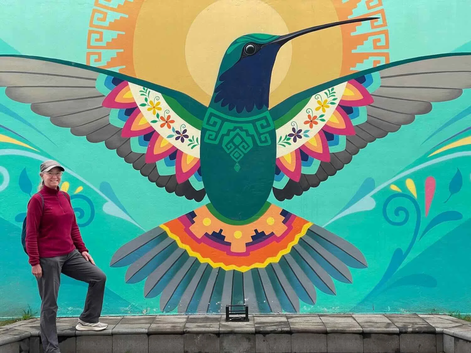
This glorious image of a hummingbird was one of several stunning murals decorating the streets of Ambato, Tungurahua Province, Ecuador. Copyright © 2019-2026 Pedals and Puffins.
Known as The Garden of Ecuador, Ambato is the biggest city in a region whose identity is strongly rooted in the production of flowers and fruit. In keeping with this image, the city has numerous public gardens. But what really stands out in Ambato’s parks is the extensive and imaginative use of topiary (cedar trees trimmed to look like statues) carved into playful shapes.
We had the chance to walk to the Juan Vela Park, one of the most famous topiary gardens in the city. The park was literally crowded with trees carved into animals, faces, dancers, different types of fruit, and even a few oddball shapes like a helicopter and a front loader. It was fun to wander among the leafy, green statues. It felt like something completely out of the ordinary.
Giant, topiary faces lined a walkway in Juan Vela Park. Ambato, Tungurahua Province, Ecuador. Copyright © 2019-2026 Pedals and Puffins.
The nearby Lover’s Park (Parque de los Enamorados) also was crowded with topiary figures, many depicting musicians and dancers. Ambato, Tungurahua Province, Ecuador. Copyright © 2019-2026 Pedals and Puffins.
We saw a couple of gardeners busy trimming the growth on some of the trees. It must take a lot of effort to keep all those topiary images looking good. Ambato, Tungurahua Province, Ecuador. Copyright © 2019-2026 Pedals and Puffins.
Escape from the Ambato Valley
From Ambato, our route continued heading northward. However, there was just one, little problem. The Ambato River Valley lay directly across our path, and we would have to traverse it to continue on our way. Furthermore, it seemed that all roads across the Ambato River used small bridges set deep in the valley, requiring a massive descent to river level, and then a brutal climb back onto the plateau. So, that’s what we did.
The day began shrouded in mist. Ten minutes into our ride, we turned our bicycles off the city streets and onto a narrow, winding road that hugged the cliff face high above the Ambato River. The huge valley opened up on our right side, but we could not see the river below. Instead, a thick blanket of clouds filled the ravine like a big, frothy, bubble bath.
The silhouettes of eucalyptus trees were just visible through the mist along the edge of the ravine. Ambato, Pan-American Highway, Tungurahua Province, Ecuador. Copyright © 2019-2026 Pedals and Puffins.
A thick layer of clouds filled the Ambato River Valley in the early morning. Yet one cluster of buildings rose up above the mist. It looked like an island in a frothy, white sea. Ambato, Pan-American Highway, Tungurahua Province, Ecuador. Copyright © 2019-2026 Pedals and Puffins.
Even while dodging heavy, city traffic we flew downhill into the river valley, reaching the bridge across the river in just half an hour. But the ascent out of the valley would present a lot more challenges.
Immediately after crossing the bridge we merged onto a much bigger avenue, with very heavy, rush-hour traffic. Without any shoulder, there was no way to cycle safely on that road.
The good news is that there was a sidewalk. However, even the sidewalk was in bad shape, with numerous cracks and potholes. With the steep gradient and rotten surface, we ended up pushing our bikes most of the way up the hill. But the most ridiculous part was that someone thought it was a good idea to plant trees right in the middle of the sidewalk. So every 20 m or so we had to squeeze around a newly-planted bush.
The road we took out of the Ambato River Valley was busy with fast-moving cars, and no shoulder to ride on. Consequently, we pushed our bicycles up out of the ravine on the sidewalk. That involved squeezing around a bush every 20 m, since someone thought it was a good idea to plant trees right in the middle of the sidewalk. Ambato, Pan-American Highway, Tungurahua Province, Ecuador. Copyright © 2019-2026 Pedals and Puffins.
Newly-planted trees weren’t the only obstacles. A dumpster was among the other items taking up most of the sidewalk. It was too dangerous to go around it by walking on the road, so we inched past the dumpster as best we could on the sidewalk. Ambato, Pan-American Highway, Tungurahua Province, Ecuador. Copyright © 2019-2026 Pedals and Puffins.
On our left side the valley wall rose steeply up from the roadway. Stairs built directly into the reinforced cliff face gave people access to the homes up above. Imagine having to carry your all your groceries up those stairs! We were intrigued to see that they had attached a few, long, flower boxes to the cliff, and filled them with plants. Ambato, Pan-American Highway, Tungurahua Province, Ecuador. Copyright © 2019-2026 Pedals and Puffins.
Eventually we climbed our way out of the canyon, and the cycling became much easier. When we finally got a decent shoulder to ride on, it was a huge relief. Our moods brightened and our pace increased. We even took the time to stop and see a few sights along the way.
Near the top of the climb out of the Ambato River Valley we passed a military academy called the School for the Formation of Soldiers. The academy was moved to Ambato in 2002, in part because of its location near the center of the country. Ambato, Pan-American Highway, Tungurahua Province, Ecuador. Copyright © 2019-2026 Pedals and Puffins.
We stopped for a break at the Yambo Lake Overlook. Famous for its unusual, green color, Yambo Lake is also the setting for several local legends. One story claims that the lake, which has no obvious water inflow or outflow, actually has no bottom and is filled with water from deep within the earth. Other people say that they have seen a ghostly train pass on the nearby, abandoned railroad tracks at night. North of Ambato, Pan-American Highway, Cotopaxi Province, Ecuador. Copyright © 2019-2026 Pedals and Puffins.
Around noon, we cycled into one of those zones that is overrun with shops all selling the same, regional product. In this case, the continuous stream of signs along the highway promoted Helados de Salcedo (“Salcedo Ice Cream”) - each one displaying the signature, conical-shaped, four-colored treats.
The Helados de Salcedo have a history almost as colorful as their layers of ice cream. They apparently were invented by Franciscan nuns who lived in the town of Salcedo long ago. The nuns raised money by producing smoothies for sale, using locally available fruits. Yet rather than discard the leftovers, they would pour them into cups and freeze them, yielding layers of frozen, creamy fruit. They would then re-sell the frozen, cup-shaped cones as an ice cream treat. In the 1950s, several local families standardized and adapted this practice, creating the modern version of the Helados that have become part of the culinary and cultural fabric of the town.
These days the Helados de Salcedo sold from roadside stands can include dozens of flavors. But all of them claim to be made in small batches, using fresh, locally-grown fruits and cream (plus a lot of vanilla). What is now known as the “traditional” form is still the most popular, with four layers: coconut, blackberry, passion fruit, and mango.
By the time we hit the Salcedo ice cream zone the afternoon was getting warm, so of course, we had to try some. Take it from us, the traditional Helados de Salcedo are absolutely delicious and unlike any other ice cream we have ever eaten.
We couldn’t miss the fact that we had arrived in Helados de Salcedo (ice cream) country. Pretty quickly, the side of the road was packed with signs promoting the multi-layered, conical, ice cream treats. Near Salcedo, Pan-American Highway, Cotopaxi Province, Ecuador. Copyright © 2019-2026 Pedals and Puffins.
Even the local guinea pigs enjoyed a Salcedo ice cream treat (at least, according to this sign). Panzaleo, Pan-American Highway, Cotopaxi Province, Ecuador. Copyright © 2019-2026 Pedals and Puffins.
We landed for the night in the bustling, historic center of the town of Latacunga (pop. 77,270). Popular as a gateway city for visiting Cotopaxi National Park, Latacunga also had a well-preserved center with colonial style buildings and cobblestone streets. We enjoyed an afternoon walking around the old city, with spectacularly clear weather - a relatively rare gift in Ecuador’s highlands.
The central statue in Latacunga’s main plaza honored Vicente León, a major benefactor for education in the city’s early years. (Cathedral of Latacunga in the background.) Latacunga, Cotopaxi Province, Ecuador. Copyright © 2019-2026 Pedals and Puffins.
The most striking “trees” in Vicente León Plaza were the towering Spineless Yucca Trees (Yucca gigantea), giving the park a distinctly tropical feel. Latacunga, Cotopaxi Province, Ecuador. Copyright © 2019-2026 Pedals and Puffins.
In the evening, a canopy of colorful umbrellas brightened a pedestrian street. Latacunga, Cotopaxi Province, Ecuador. Copyright © 2019-2026 Pedals and Puffins.
Would We See the Cotopaxi Volcano?
As part of the Avenue of the Volcanos, the route between Latacunga and Quito passes right by Cotopaxi National Park, and is renowned for its views of the famous Cotopaxi Volcano. Cotopaxi is Ecuador’s second-highest mountain, and one of the tallest, active volcanos in the world (the last eruption was in 2023). Unfortunately for us, the day we departed Latacunga it was extremely cloudy, and there was no hope of seeing the snow-clad peak. What’s more, the landscape close to the highway wasn’t that interesting, so we mostly just blasted through the cycling for the day.
As we exited the city, we cycled past an overpass decorated with a skyline of the city and profile of the Cotopaxi Volcano (far left). Supposedly you can see the volcano from here on clear days. But due to a thick layer of low clouds, the image on the overpass would be the closest we’d come to seeing the volcano that day. Latacunga, Pan-American Highway, Cotopaxi Province, Ecuador. Copyright © 2019-2026 Pedals and Puffins.
Just north of town we passed another military installation - this time it was a special forces training camp, with monuments honoring veterans and highlighting the role of paratroopers. Latacunga, Pan-American Highway, Cotopaxi Province, Ecuador. Copyright © 2019-2026 Pedals and Puffins.
We spent the next night in a tiny, rustic lodge in the village of Anita Lucía de Quisinche (pop. 876) that caters to adventurers headed to Cotopaxi National Park.
The next morning, our luck with the weather changed. The day dawned cold and clear, with a stunningly blue sky. As you might imagine, the big highlight of the day was that we finally got to see the Cotopaxi Volcano.
We had pulled over to the side of the road to takeoff our sweaters, not really thinking about what we might see there. However, when we looked back in the direction from which we had come, we discovered that Cotopaxi was peeking through a low spot in a nearby ridge. It was obviously a much higher mountain than the others in the area, because its perfect cone was completely covered with glistening, white snow. (Of all Ecuador’s volcanos only seven, including both Chimborazo and Cotopaxi, are high enough to have year-round snow.)
We stood there for quite a while, waiting for the clouds that seemed stuck to the top of Cotopaxi’s cone to blow away. Then finally, the majestic volcano was revealed in all its glory.
From the side of the Pan-American Highway we could just see the top of the Cotopaxi Volcano peeking over a ridge in the mountains. El Rosal, Pan-American Highway, Pichincha Province, Ecuador. Copyright © 2019-2026 Pedals and Puffins.
It is always astonishing to see so much snow, on a mountain so close to the equator. But at 19,347 ft in height (5,897 m), the Cotopaxi Volcano is always covered in snow. El Rosal, Pan-American Highway, Pichincha Province, Ecuador. Copyright © 2019-2026 Pedals and Puffins.
The other great thing about that day was that our ride was nearly all downhill. From the village of Anita Lucía to Valle de los Chillos (pop. ~20,000) we descended nearly 2,400 ft (730m). It was a blast to cruise into the outskirts of Quito, the second-largest city in the country and the capital of Ecuador, without having to pedal very much.
A Haven for Frogs
Before heading into the heart of Quito, we decided to spend a day in the Valle de los Chillos and visit an unusual attraction called the Wikiri Saproparque. The name may look odd in English, but that’s because it is a combination of indigenous and Spanish terms that essentially translates into “Frog Park.”
And Ecuador is very proud of its frogs. It ranks among the top five countries in the world for frog diversity, and is often credited with having the highest density of frog species per unit area of any country on Earth (a consequence of its relatively small size). We easily understood why Ecuador had so many frogs. With all the rain, we sometimes felt like amphibians ourselves.
However, that also meant that Ecuador was one of the countries hardest hit by the spread of a deadly disease called the chytrid fungus that has been decimating frog populations worldwide since the 1980s. The Wikiri Saproparque is essentially a place where the public can get an intimate look into some of Ecuador’s cutting-edge efforts to combat the disease.
At its heart, the Wikiri Saproparque is a captive breeding facility for many of the country’s most threatened frogs and toads. As visitors, we received a personalized tour that showcased around 30 species, ranging from tiny, poison dart frogs to bulky toads the size of a large grapefruit.
The entire tour was excellent, but one of our favorite parts was the visit to the “frog kitchen” where the head “chef” explained how they produce all of the food (millions of live insects) that is needed to nourish roughly 9,000 captive frogs. Through their research, the scientists have learned that some frogs require special foods like mites (to help them make the poison in their skin), weevils (that actually stay alive inside the frog’s stomach to stimulate digestion), and beetle larvae (calorie-dense food that helps sick frogs recover). We learned a lot, and had a fantastic time at the Wikiri Saproparque.
Entrance to the Wikiri Saproparque, one of Ecuador’s leading frog conservation centers. Valle de los Chillos, Pan-American Highway, Pichincha Province, Ecuador. Copyright © 2019-2026 Pedals and Puffins.
One of the resident frogs on display at the Wikiri Saproparque near Quito. Valle de los Chillos, Pan-American Highway, Pichincha Province, Ecuador. Copyright © 2019-2026 Pedals and Puffins.
PedalingGal enjoyed meeting the “head chef” in charge of frog food production at the Wikiri Saproparque. He explained how the center produces millions of insects (in the containers to the right) each day, to keep 9,000 captive frogs healthy and well fed. Valle de los Chillos, Pan-American Highway, Pichincha Province, Ecuador. Copyright © 2019-2026 Pedals and Puffins.
Exploring Quito, the Capital of Ecuador
We expected the final ride into Quito to be stressful, so we intentionally planned to keep it short so that we could take our time. Even so, it was a wild ride. From the Valle de los Chillos we had to climb back up onto the plateau where Quito sits.
There was so much traffic that the highway we were cycling had been widened into three lanes of traffic in each direction. Unfortunately, it appeared as though they had sacrificed the road shoulder to create the third lane. So for the entire approach to Quito we had no shoulder to ride on. The best we could do was to stay on the right-hand side of the right lane. We wore our fluorescent-colored vests to give us extra visibility, but it was pretty stressful.
A suburb of Quito, nestled among the surrounding hills. Quito, Pichincha Province, Ecuador. Copyright © 2019-2026 Pedals and Puffins.
Nearly every day since arriving in Ecuador we had been contending with bouts of rain, which was starting to become rather tiresome. However, there was some good news on the horizon. The Ecuadorian dry season was supposed to begin soon - at least in theory. In addition, there was an upcoming, contentious election in Colombia which we would rather avoid.
So with plenty of time remaining on our 90-day visas, we decided to linger in Quito for the remainder of the month of May. That would let us depart right in time to enjoy some drier weather, and to let the political dust settle before crossing the border into Colombia.
The area of Quito where we stayed (around La Carolina Park) turned out to be a great place for an extended layover. The park had miles of walking paths, a half-mile (1 km) running track, and an excellent outdoor exercise area. Every Sunday, the Ciclopaseo (15 miles of closed city streets, dedicated to bicycle travel) passed right along the side of the park, giving us easy access. On most days we were able to get outside and enjoy the park.
Once you’re inside the city, Quito is a pretty good place for bicycles. There were lots of bicycle paths. And every Sunday, 15 miles (24 km) of the city’s streets were closed to vehicle traffic, for the weekly Ciclopaseo. Quito, Pichincha Province, Ecuador. Copyright © 2019-2026 Pedals and Puffins.
While it’s surrounded by dense, urban development, La Carolina Park is big enough that once your inside it, you can feel like you’ve left the urban congestion behind. Quito, Pichincha Province, Ecuador. Copyright © 2019-2026 Pedals and Puffins.
Right in the center of La Carolina Park there was a half-mile (1 km) running track, with an outdoor gym next to it. We spent many mornings working out on the track and the outdoor gym equipment. Quito, Pichincha Province, Ecuador. Copyright © 2019-2026 Pedals and Puffins.
La Carolina Park also had a couple of “work out” areas for dogs - like this free, agility training course. Quito, Pichincha Province, Ecuador. Copyright © 2019-2026 Pedals and Puffins.
One of the hidden gems in La Carolina Park was the Quito Botancial Garden. Exhibits featured most of Ecuador’s major vegetation zones, including a greenhouse devoted to carnivorous plants like this one. Quito, Pichincha Province, Ecuador. Copyright © 2019-2026 Pedals and Puffins.
Of course, Quito had plenty of other attractions as well. Whenever the weather cleared, we could see the mystical, snowy cone of the Cotopaxi Volcano in the distance.
The morning sun cast a warm glow on the upper slopes of the Cotopaxi Volcano. On clear days, we could see the distant volcano from the window of our hotel. Quito, Pichincha Province, Ecuador. Copyright © 2019-2026 Pedals and Puffins.
In addition, the historic city center is so well-preserved that it was among the first few places added to the list of UNESCO World Heritage Sites in 1978. In addition to its handsome plazas, the historic center is brimming with colonial-era churches (30), convents (7) and monasteries (6). Historically, the racket from the tolling of all those church bells was so bad that the city eventually passed a noise ordinance forbidding the ringing of bells during the night or early in the morning.
A grand monument honoring the heroes of Ecuador’s fight for independence marked the center of Independence Plaza - in the heart of Quito’s historic district. Quito, Pichincha Province, Ecuador. Copyright © 2019-2026 Pedals and Puffins.
The Hotel Plaza Grande overlooked one side of the Independence Plaza. Built to resemble an Italian palace, the site was occupied by wealthy families for centuries, before being converted to a hotel in the early 1900s. Quito, Pichincha Province, Ecuador. Copyright © 2019-2026 Pedals and Puffins.
The historic city center packed in 30 churches and chapels, mostly dating back to the early colonial era. The Compañía de Jesus Church stood out as having one of the most intricately carved, baroque facades in the city. The interior is supposed to be especially grand. Nearly every indoor surface - walls, columns, vaults, altars - is covered in 23‑carat gold leaf. Estimates suggest that more than a ton of gold was used to decorate that church. Quito, Pichincha Province, Ecuador. Copyright © 2019-2026 Pedals and Puffins.
Several streets near the historic center were crowded with artists and craft shops. We found this art, painted on natural feathers and leaves, to be particularly lovely and unique. Quito, Pichincha Province, Ecuador. Copyright © 2019-2026 Pedals and Puffins.
Not every store near the center was a souvenir shop. We were impressed by the sheer size of this running shoe store. It seemed like the biggest running shoe store we had ever seen. Quito, Pichincha Province, Ecuador. Copyright © 2019-2026 Pedals and Puffins.
The Sunday Ciclopaseo (15 miles of city streets closed to vehicles) was particularly enjoyable in Quito. Because the city sits in a narrow valley, it is linear by nature. As a result, the long, fairly straight Ciclopaseo route takes cyclists through many parts of the city, from outlying neighborhoods to the historic center.
Unlike ciclovía events in other Latin American cities that we had joined, where there seemed to be just as many walkers as cyclists (if not even more), the Ciclopaseo in Quito was overwhelmingly attended by people just riding bicycles. No matter what part of the city we rode through, there were tons of other cyclists out on the road with us - ranging from young families to serious road cyclists.
During the Sunday Ciclopaseo, cyclists like us had a road that cut right through the historic old town all to ourselves - no cars to worry about. Quito, Pichincha Province, Ecuador. Copyright © 2019-2026 Pedals and Puffins.
Away from the city center, the Ciclopaseo headed down wider roads. It was always crowded with people. Quito, Pichincha Province, Ecuador. Copyright © 2019-2026 Pedals and Puffins.
In the northern part of the city, the grounds of the old Quito Airport (which moved out of the city in 2013) have been repurposed into the Bicentennial Park. Within the park, the former runways can be used for cycling, which is pretty cool. We took a detour to Bicentennial Park one weekend, and were surprised to see a couple of teams playing kickball - a game you just don’t see played by adults much these days. Quito, Pichincha Province, Ecuador. Copyright © 2019-2026 Pedals and Puffins.
Not every bicycle ride ends happily. This statue in La Carolina Park was a memorial to victims of road accidents. Quito, Pichincha Province, Ecuador. Copyright © 2019-2026 Pedals and Puffins.
In addition to all those churches, Quito had around 40 museums. One of the biggest was the National Museum of Ecuador, which we visited one afternoon. The exhibits ranged from pre-Colombian artifacts, through the colonial era, the period after independence, and even modern art. We enjoyed seeing the range of exhibits, showcasing the breadth of Ecuador’s history.
It felt like this cloth map was made for us. It depicted a trade route, starting in La Paz (Bolivia) in the south, running through Lima, Quito, and Bogotá, ending at Cartagena in the north. That’s pretty much the route we took on our bicycles. National Museum of Ecuador, Quito, Pichincha Province, Ecuador. Copyright © 2019-2026 Pedals and Puffins.
Most of the artwork from the colonial era was devoted to religious expression. National Museum of Ecuador, Quito, Pichincha Province, Ecuador. Copyright © 2019-2026 Pedals and Puffins.
The museum housed Ecuador’s most extensive collection of pre-Colombian art. National Museum of Ecuador, Quito, Pichincha Province, Ecuador. Copyright © 2019-2026 Pedals and Puffins.
Perhaps the two most emblematic sights in Quito were the National Basilica and the statue of the Virgin of Panecillo. Both structures sit on top of prominent hills overlooking the historic center from opposite sides, and are visible from places throughout the city.
Built between 1892-1988, the National Basilica is much newer than most of Quito’s churches. It was commissioned by the federal government to commemorate the country’s formal consecration as an officially Catholic nation, and was blessed by Pope John Paul II.
However, according to the city tour we took, most people in Quito haven’t really embraced the “new” church, and prefer the older parishes in town. Some legends say the Basilica is haunted. And a widely repeated story says that the church has to remain “unfinished”, because if it is ever completely finished, the world will end. Supposedly that is why a dozen niches on the outside of the church were never filled with statues - because that would “complete” the church.
One of the National Basilica’s unusual features was that the stone gargoyles were carved in the shape of native, Ecuadorian animals. The gargoyles in this photo represented armadillos, sheep, and marine iguanas. Quito, Pichincha Province, Ecuador. Copyright © 2019-2026 Pedals and Puffins.
This window on the front of the National Basilica symbolized the country’s devotion to the Sacred Heart of Jesus. It was also designed so that a person standing at the altar within the church, looking out through the window, would see the statue of the Virgin of Panecillo atop another hill, on the far side of the old city. Quito, Pichincha Province, Ecuador. Copyright © 2019-2026 Pedals and Puffins.
The Virgin of Panecillo statue (top of hill, center of photo) could easily be seen from many viewpoints throughout southern Quito. Built in 1975, it was a very unusual representation of the Virgin Mary - with wings, a crown of stars, and trampling a snake (similar to an apocalyptic image in the Bible). For many people in Quito, she is seen as a protector of the city. Quito, Pichincha Province, Ecuador. Copyright © 2019-2026 Pedals and Puffins.
Looking back towards the north, the soaring bell towers of the National Basilica rose up from the top of another hill - an iconic element of Quito’s distinctive skyline. Quito, Pichincha Province, Ecuador. Copyright © 2019-2026 Pedals and Puffins.