Cycling Bolivia’s Altiplano, Part 1: Villazón to Uyuni
6 - 23 September 2025
6 Sept - La Quiaca, Argentina to Villazón, Bolivia (2.1 mi, 3.4 km)
7-8 Sept - Wind Days in Villazón
9 Sept - Villazon to Fallow Field Wild Camp (38.3 mi, 62.4 km)
10 Sept - Fallow Field Wild Camp to Tupiza (18.4 mi, 29.6 km)
11 Sept - Rest day in Tupiza
12 Sept - Tupiza to Cactus Wild Camp (21.6 mi, 34.8 km)
13 Sept - Cactus Wild Camp to Llama Wild Camp (15.0 mi, 24.1 km)
14 Sept - Llama Wild Camp to Atocha (29.9 mi, 48.1 km)
15 Sept - Rest day in Atocha
16 Sept - Atocha to Blowing Sand Wild Camp (33.1 mi, 53.3 km)
17 Sept - Blowing Sand Wild Camp to Uyuni (25.5 mi, 41.0 km)
18-23 Sept - Layover in Uyuni
Cycling Into Thin Air
It started as a dull headache halfway up a big climb. Within minutes PedalingGal had pain in her ears and was having trouble concentrating. As she rested by the side of the road she gasped for air, and a nauseous feeling settled in her stomach. At an elevation of nearly 14,000 ft (4,267 m), the altitude was finally taking its toll.
At those heights the air is much thinner - with more than 40% less oxygen per breath than at sea level. So although we were unaffected by Bolivia’s gasoline crisis (a huge advantage of traveling by bicycle), we were still running into our own version of a fuel shortage as we struggled to take in enough oxygen to power our leg muscles.
A week earlier we had crossed the border from Argentina into Bolivia. By that time we had already ascended onto the Altiplano - the largest, high-altitude plateau in the Americas - and we were getting used to cycling at lofty elevations. The average elevation of the altiplano is 12,300 ft (3,750 m). Yet Andean ridges that sneak out onto the plateau can be a couple of thousand feet higher than that, and we have found there is a big difference between cycling at 12,000 feet and 14,000 feet or more.
As a result, when we hit one of those ridges we were like athletes that train high in the mountains to increase their aerobic capacity - pushing close to our limits in the thin, Andean air. Fortunately, we were prepared. We were carrying a medicine which helps reduce the effects of hypoxia by increasing the body’s ability to take in oxygen. After swallowing a dose of acetazolamide and resting for a few minutes PedalingGal started feeling better, although still rather winded from the exertion.
In spite of the fact that the thin air makes physical activity more difficult, the altiplano zone of Bolivia has been an essential travel corridor for millennia - as trading caravans and invading armies traversed the landscape between the empires of Peru and the fertile lowlands of Argentina. Even today, it is a major transportation corridor through otherwise impassable mountain ranges of the Andes. Consequently, our route northward would remain entirely on the altiplano as we cycled across Bolivia. For the next couple of months we would only occasionally go below 11,000 feet.
Into Bolivia
Crossing the border was pretty straightforward. Both the Argentinian and Bolivian immigration offices occupied the same building. So we were able to push our bicycles through the pedestrian line, stopping first at the Argentinian desk, then proceeding to the Bolivian desk. We were barely able to squeeze through with our bikes in tow, which was necessary since there was nowhere to leave them outside.
The exit from Argentina took just a minute or two, as the border agent quickly reviewed our passports.
Bolivia was nearly as fast. Even though the bored-looking immigration officer carefully read the information on our visa stamps and entered some data into her computer, she otherwise didn’t care to interact with us at all. If we hadn’t accidentally wasted another five minutes waiting in the Bolivian customs line - which a kindly official eventually told us we didn’t need to do - we would have been through the whole immigration process in less than 10 minutes.
The border crossing into Bolivia. Both the Argentinian and Bolivian immigration desks were inside the same building, reached via the pedestrian walkway on the right. Villazón, Potosí Department, Bolivia. Copyright © 2019-2025 Pedals and Puffins.
Once across the border we found ourselves on a narrow street rising rapidly away from the river that separates Bolivia from Argentina, into the heart of Villazón (pop. 49,300). Every inch of space on both sides of the road was lined with tiny shops - each no more than 10 ft wide (3 m) - packed to the gills with everything from clothes, to hardware, to household goods. There also were at least a dozen money-changers, and the sidewalks were crowded with people.
In the end, it was easiest to just walk our bicycles nearly all the way to our hotel, weaving our way through the river of pedestrians along bumpy cobblestones. On the plus side, we gained an hour at the border. Bolivia’s time is one hour behind Argentina’s.
When we arrived at our hotel, we were surprised by how small it was. The Hotel Casa Grande is known as one of the better lodging options in Villazón. Plus, with a name that translates to ‘The Big House,’ we had just assumed it would be fairly large. But there were only three rooms, one of which was occupied by the very sweet owners. We felt fortunate to get one of the other two rooms. Yet on our first night we were the only guests at the hotel, even though Alfredo (one of the owners) spent the afternoon at the bus station in La Quiaca (Argentina) hoping to rustle up some additional guests.
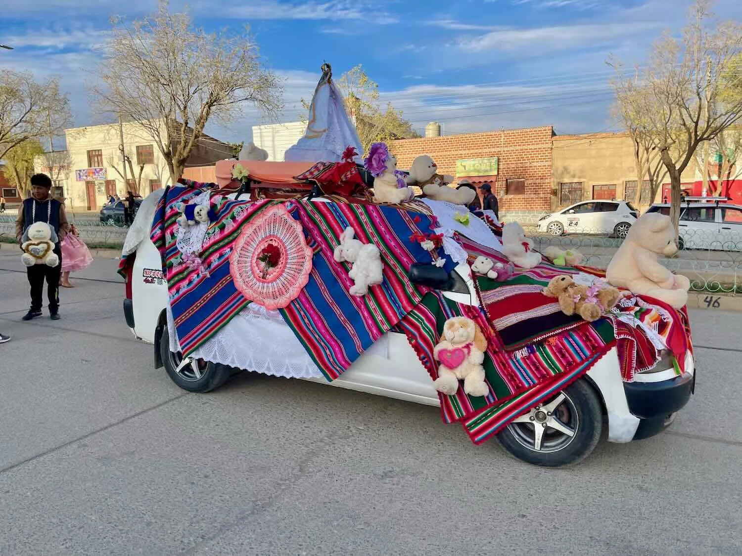
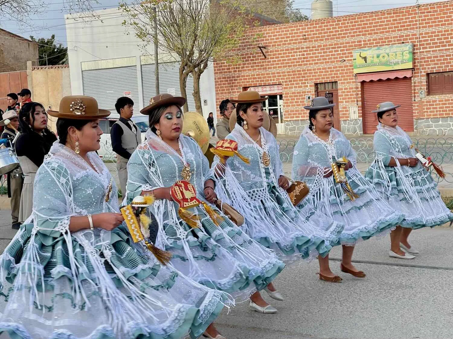
Later that afternoon we could hear a marching band playing, not too far away. When it was time for dinner we decided to follow the music to see what was happening. Out on the main road we found a car that had been completely draped in bright, colorful fabric, with an image of the Virgin on top and maybe 20 stuffed toys attached. Behind the car were several groups of women in really elaborate, matching chola dresses (the traditional outfit for native, highland women) and a marching band (the source of the music). The car rolled forward ever so slowly, with the women parading behind it using the same, twirling dance steps that we had seen at a religious procession in La Quiaca. Sadly, we did not learn what they were celebrating, although our guess was a wedding.

The weather forecast called for strong winds over the next two days, tapering off on the third day. So even though we were eager to get rolling, we extended our stay in Villazón to save ourselves from the misery of cycling into powerful headwinds.
The most notable feature of the town was its open-air market. With prices much lower in Bolivia than in neighboring Argentina, Villazón is a major shopping destination for Argentinians crossing the border. As a result, several days each week 25 square blocks of the city’s streets become impassable to cars as they fill up with the tent canopies of individual proprietors, each hawking everything from toys to toiletries. There were no souvenirs to be seen, anywhere. All of the items for sale were practical goods that ordinary folks would buy - especially mountains of clothing, shoes and housewares.
One section was known as the farmers’ market, where folks would sell piles of produce from neighboring farms. All of the fruits and vegetables looked incredibly fresh - even better than what we had seen in Argentina. We later learned from the folks at the hotel that the area around Villazón is particularly fertile, allowing farmers to grow lots of fruits and vegetables, even for export. The high altitude results in very cold nights, which we were told means that there are few bugs. Thus the local farmers don’t have to use chemicals to control pests - making the produce especially desirable for folks who prefer organic.
A tired, fruit vendor rested while waiting for customers at the municipal farmers’ market. Villazón, Potosí Department, Bolivia. Copyright © 2019-2025 Pedals and Puffins.
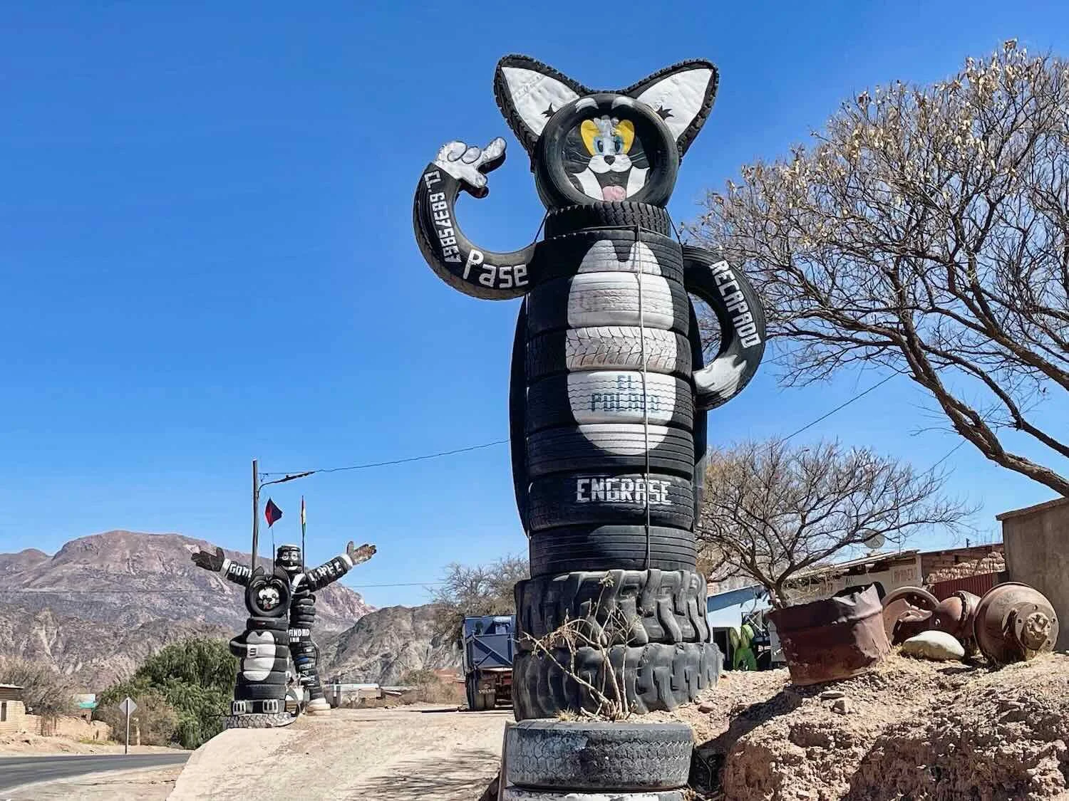
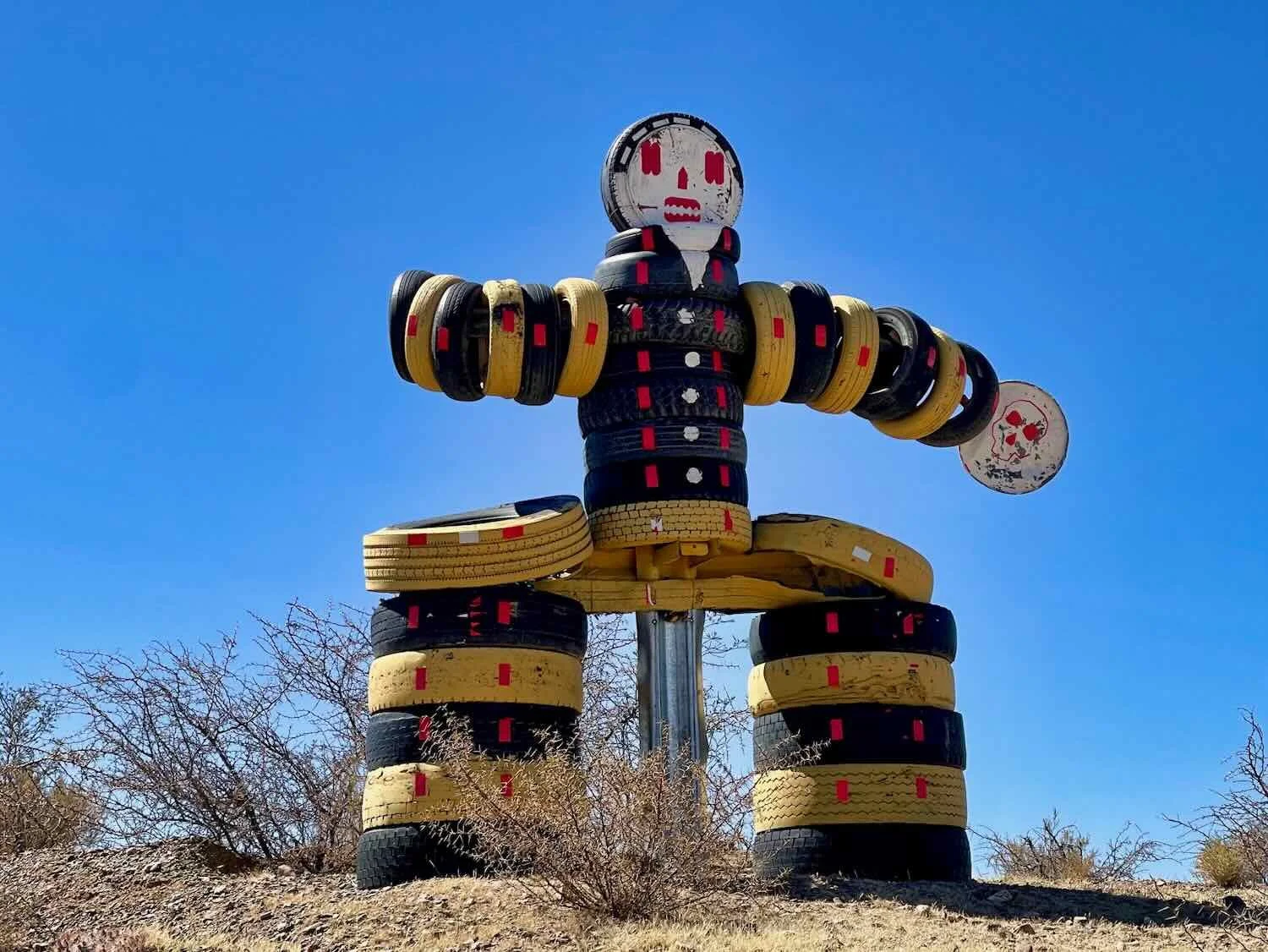
Near one side of the outdoor market sat a whimsical tank statue, constructed almost entirely from old tires. Villazón, Potosí Department, Bolivia. Copyright © 2019-2025 Pedals and Puffins.
Also near the market stood a large sports complex. Inside the stadium was basketball court that had been repurposed as an indoor soccer field. Later we would see many of these big stadiums throughout Bolivia, including in very small towns where they seemed rather out of place. Villazón, Potosí Department, Bolivia. Copyright © 2019-2025 Pedals and Puffins.
Even though the market was well stocked with produce, cooked vegetables were very scarce in Villazón’s restaurants. On the other hand, rice and potatoes (fried or boiled) were ubiquitous. Some restaurants also served lettuce, tomato and onion salads on the side. But having heard numerous horror stories about cases of salmonella, E. coli, and other intestinal maladies from other travelers in Bolivia, we were loathe to eat any uncooked vegetables or salads. Before long we started to really miss vegetables.
On the second morning we asked our host, Alfredo (Fredy), if we could buy extra eggs to go with our breakfast (the breakfast that came with the room only included one egg each). Cycling makes us hungry, so we asked if we could have a total of eight eggs between us. Fredy (who had a good sense of humor) acted like he thought eating that many eggs was crazy, but he was happy to oblige.
As part of the conversation, Fredy mentioned that his wife, Ivón (who he referred to as his ‘boss wife’), would often cook vegetarian dinners for foreign guests. Although we are not vegetarian, the idea of having some cooked vegetables with our dinner sounded amazing, so we arranged to have dinner at the hotel. That night we had a wonderful meal that included cooked broccoli, carrots and lentils. It was deeply satisfying after several days of just eating meat and potatoes.
Onto Bolivia’s Altiplano
Our first night in Villazón we heard that it had snowed in the next town up the road (Tupiza). And each afternoon the wind howled through town, with gusts up to 50 mph (80 kph). But finally, on the third morning the weather improved enough for us to mount our bicycles and get back on the road.
Ready for departure from Villazón. We posed for a photo outside the hotel with our friendly hosts, Fredy (Buffalo Bill) and Ivón. We got a kick out of Fredy’s nickname, and he enjoyed hearing that there was a very good American football team with the same name. Villazón, Potosí Department, Bolivia. Copyright © 2019-2025 Pedals and Puffins.
It was a beautiful, sunny day.
The first thing we noticed on the way out of town was the very long line of trucks parked along the side of the road. The line stretched for nearly a mile. At first we weren’t quite sure what to make of it. But when we reached the front of the line, there was a gas station, and we figured out what was happening - it was a gas line. Before long we realized that this was normal these days in Bolivia. With supplies short because the government can’t afford to import enough gasoline and diesel (which is heavily subsidized), drivers would queue up a day or more in advance to buy fuel.
The second thing we noticed was that the city was surrounded by a zone of abandoned buildings. There were hundreds of them. We had seen this in other towns where older homes and businesses built with natural materials deteriorated, then new buildings - often built with more modern materials - take their place. Rather than tear down the old buildings they are left to natural decay over time.
Some of the many abandoned buildings along the highway north of Villazón. There were hundreds of these structures covering the landscape. Matancillas, Potosí Department, Bolivia. Copyright © 2019-2025 Pedals and Puffins.
It wasn’t until we were 15 min outside of the city’s footprint that we finally encountered a “Welcome to Bolivia” sign (there hadn’t been anything fancy at the border). But it was worth the wait - an impressive arch stretched across the highway in the otherwise empty grasslands. N of Villazón, Potosí Department, Bolivia. Copyright © 2019-2025 Pedals and Puffins.
When we arrived in the village of El Tambo (pop. <100), it was still early in the afternoon. We had originally planned to spend the night there. But we were feeling energetic, and there was plenty of daylight left. Pretty soon we decided to grab a quick meal at a small, roadside shack that posed as a restaurant before continuing down the road. There were two tables outside and no menu. No menu was not a problem because deciding on your meal was easy, since they only served the same plate of food to everyone. We got lucky, and the meal was really good - better than any of the restaurants we had visited in Villazón.
Then we tried going over to the only lodge in town, because we heard they had a shop where we could stock up on drinks. The hospedaje was quite big, and rather fancy for such a small town. It had a playground for kids, lots of outdoor grills for picnics, and a pool. However, it was deserted. We walked all around the grounds, calling out and knocking on doors, but no one answered. If there was a store on the premises, we couldn’t find it. We counted our blessings that we had decided not to stay there. If it had been later in the day, we might have been in a bind. But we had other options, so we just moved on - hoping we could find somewhere to buy more drinks further down the road.
Our luck held, and within half an hour we passed a town with a row of food stalls, most of which were selling drinks. We topped up our supply, now fully stocked for a night of camping.
Our final hour of cycling was the easiest of the day. Not long after departing El Tambo we began an extended descent that lasted for the rest of the ride - dropping nearly 2,000 ft (610 m) into a river valley. As we lost elevation, the valley walls rose up on both sides, still covered with the short grass and scruffy shrubs of the puna. We even crossed paths with another cyclist, as he was laboring up the hill in the opposite direction. We didn’t visit for long, because he was still hoping to reach Villazón by nightfall. But we did learn that Casper was from Poland, and was returning south after having made a loop that started in Tierra del Fuego. This was the third time we had met cyclists from Poland on this trip - once in California, once in Argentina, and now in Bolivia.
The hills of the puna grasslands rose on both sides of the highway as we descended into a river valley. N of Yuruma, Potosí Department, Bolivia. Copyright © 2019-2025 Pedals and Puffins.
Can you see the bird in this photo? We spotted this cryptically-colored Tinamou at the edge of an agricultural field. Like their cousins the ostriches, rheas and kiwis, they have very short tail feathers (looking almost tailless). Yuruma, Potosí Department, Bolivia. Copyright © 2019-2025 Pedals and Puffins.
When we reached the San Juan del Oro River at the bottom of the descent, it was time to look for a camping spot. From the bridge we followed a rough dirt track upstream into a canyon among the hills. The road ended at a partially-plowed agricultural field. Since it looked like the only person that had used the dirt track recently was the farmer (in order to get to his field with a tractor), we decided to go ahead and pitch our tent on the dirt track next to the field. Fortunately, everything worked out fine. We enjoyed a quiet night far from the highway, listening to the sounds of a hooting Lesser Horned Owl, and the occasional bark of an Andean Fox (Culpeo) that seemed annoyed by our presence.
View of the San Juan del Oro River, from the highway bridge. Like all of the major rivers on the altiplano, it had a very wide floodplain with lots of little channels cut through the gravel. Supira, Potosí Department, Bolivia. Copyright © 2019-2025 Pedals and Puffins.
We camped on a dirt road next to a partially-plowed agricultural field, bordered by the canyon walls of the San Juan del Oro River valley. Potosí Department, Bolivia. Copyright © 2019-2025 Pedals and Puffins.
In the Footsteps of Butch Cassidy and the Sundance Kid
Having covered an extra 11 miles (17.7 km) the day before, we had a relatively short bike ride into the town of Tupiza. Thus we allowed ourselves the luxury of sleeping in until the sun had come up over the rim of the canyon, warming our tent and making it that much easier to start our day. Another benefit was that, with the big descent yesterday we were now at roughly 9,000 ft (2,745 m) in elevation - with almost 25% more “effective oxygen” than we had up in Villazón. That helped us feel stronger (although the relatively low elevation would not last for long).
For the first hour we cycled through a series of small, frontier towns. The village of Santa Rosa (pop. 503) stood out for having a group of sculptures built from of old tires that lined the road near a tire repair shop. They reminded us of the battle tank made out of old tires that we had seen in Villazón (photo above).
This simple stone chapel sat on top of a ridge near the first town that we passed through. Charaja, Potosí Department, Bolivia. Copyright © 2019-2025 Pedals and Puffins.

The highlight of the day’s ride came after we left the towns behind and entered a scenic canyon, where rivers cut through a ridge of the Andes mountains that extended out onto the altiplano. We stopped often along this stretch of the highway to admire the rugged cliffs and relatively lush forest that grew along the river banks.
A railroad paralleled the highway through the scenic San Juan del Oro Canyon, Potosí Department, Bolivia. Copyright © 2019-2025 Pedals and Puffins.
A flock of Yellow-billed Pintails was attracted to the river. San Juan del Oro Canyon, Potosí Department, Bolivia. Copyright © 2019-2025 Pedals and Puffins.
The plants that grew along the road were fairly harsh, like this Caven Thorn with its very sharp, white spikes. Tupiza River Canyon, Potosí Department, Bolivia. Copyright © 2019-2025 Pedals and Puffins.
The highway cut through a narrow gap in the mountain ridge. Tupiza River Canyon, Potosí Department, Bolivia. Copyright © 2019-2025 Pedals and Puffins.
There was even a short stretch of tunnel, where the highway burrowed through the mountains. El Angosto Tunnel, Tupiza River Canyon, Potosí Department, Bolivia. Copyright © 2019-2025 Pedals and Puffins.
Before long we rolled into the town of Tupiza (pop. 35,800). Tupiza is best known for being the last town to have suffered a robbery by Butch Cassidy and the Sundance Kid - two notorious bandits that fled to Bolivia to escape from law enforcement in the American West. The final days of these two outlaws are shrouded in myth, but the most widely known version (portrayed in the classic 1969 Western movie) had them fleeing Tupiza in 1908 to a mining town about 40 miles west, where they were discovered by the Bolivian army and killed in a shoot-out. To this day, multiple businesses in Tupiza use references to Butch Cassidy and the Sundance Kid to attract tourists, and it is possible to go on tours to the site of their final train heist, as well as the remote cabin where they met their fate.
Our Own Run-In with Bolivian Banks
Our visit to Tupiza had echoes of the outlaws’ hunt for money. Bolivia is very much a cash economy, with very few businesses accepting credit cards. Those that do take credit give an artificially low exchange rate that is enforced by the government, so paying with plastic is more expensive than cash. Although we had changed some Argentinian pesos to bolivianos (the local currency) in Villazón, we were already worried about how long our cash would last.
However, figuring out the best way to get cash in Bolivia can be a challenge. Using bank ATMs was out of the question, because they only dispense small amounts of cash, and they also use the low, government exchange rate.
On the other hand, there is a black market where U.S. dollars can trade for almost double the official rate. In addition, other ways of getting money (such as money transfer services) can also give rates 50-90% higher than the government rate. We had gotten used to using Western Union (WU) in Argentina, so that was an option. However, we’d heard numerous times that other services like Xoom (a service run by PayPal) offered better exchange rates than WU. Supposedly there was a bank in Tupiza where we could use Xoom. But things didn’t go quite as planned.
We ended up spending most of our rest day running around between the three commercial banks in Tupiza in an increasingly urgent search for cash. After waiting in multiple, long banking lines, tellers at all three banks informed us that they did not handle Xoom transfers, despite the information to the contrary provided by Xoom’s website. Each bank also suggested that we go to the other banks, which of course didn’t work. By the time we had visited all three banks at least once, it was almost noon. We had exhausted all our options, so we returned to our hotel to regroup.
It looked as though a couple of the banks would handle Western Union transfers, so we decided to give that a try. But the obstacles continued. We waited another hour in a bank line, only to be told that they could not give us our money because the name associated with the transaction did not exactly match the name on PedalingGuy’s passport (he never uses his middle name except on his passport). And the names MUST match exactly. This was never a problem in Argentina or Chile where the lack of a middle name on the transaction was accepted at many different Western Unions. We were instructed to go online and correct the name on the transaction.
We sat down in the bank’s lobby and began to call up the app on a mobile phone, but then a security guard came over and told us that using mobile devices was prohibited inside the bank. This was the second time we were admonished by the security guard. Apparently wearing hats in the bank was also against the rules. We would have to go outside if we wanted to use a mobile phone. So… we walked over to the town plaza where we could sit on a bench and correct the transaction - which actually involved cancelling the original transaction and creating a new one. The whole process was starting to feel like a circus.
Back at the bank we waited in line for another 20 minutes. By that time it was 1:30 in the afternoon, and guess what… the only cashier who could handle our transaction went on her lunch break just as we got to the front of the line. For real. We were told we would have to wait for her to come back from lunch. In truth, the hard-working teller only had a half hour break for lunch. But to us, it felt like another nail in the coffin. We could hardly believe our bad luck.
Once the cashier returned, we felt like we could finally see the light at the end of the tunnel. After answering a few more questions, we thought that we might actually get our money. But then… the cashier seemed to be having some kind of problem. She even called over another bank employee to look at her computer screen and get some advice. Once again, we started to worry that after all we had been through that this all might end in failure. But after another 20 minutes, it seemed as though they resolved whatever the problem was. The clouds parted, the angels began to sing, and they handed us some Bolivian cash. It was a miracle. Unfortunately many of the bills were rather worn out with tears and other defects. As we would later learn, vendors in Bolivia are particular about the cash they will accept. Bills are examined carefully and often rejected if they have tears or other issues.
Needless to say, after spending most of the day trying to hunt down cash, we didn’t have much time left to visit the town of Tupiza. There were some buildings with interesting architecture. Yet perhaps the thing that made the biggest impression on us was the prevalence of tuk-tuks. In Tupiza, the streets were crowded with tuk-tuks (which seemed to represent at least half of the vehicles on the road). It was particularly striking because we didn’t see tuk-tuks in any other Bolivian towns that we visited (everywhere else they used taxis and/or colectivos). We wondered what historical factors might have led to Tupiza’s embrace of this unorthodox form of transportation.
The Casa Castillo was one of the most noteworthy buildings in town - even more impressive than the cathedral. Tupiza, Potosí Department, Bolivia. Copyright © 2019-2025 Pedals and Puffins.
It seemed as though most of the vehicles on the road in town were tuk-tuks, which we hadn’t seen anywhere else in Bolivia. Tupiza, Potosí Department, Bolivia. Copyright © 2019-2025 Pedals and Puffins.
When the Altiplano Isn’t So Flat
As mentioned earlier, every so often a band of mountains from the Andes will sneak out onto the altiplano, interrupting the plateau’s rolling hills with some serious ridges. Heading northwest from Tupiza, we were about to encounter one of these tongues of the Andes, sending us even higher into the stratosphere.
For most of the day the cycling conditions were pretty good, as we climbed gently upstream along the valley of the Salo River. The broad floodplain was dotted with interesting rock formations, and populated mostly by goats.
Soaring rock spires jutted skyward along our route. N of Tupiza, Potosí Department, Bolivia. Copyright © 2019-2025 Pedals and Puffins.
Around midday we enjoyed an awesome break in the shade of some trees that were planted near the road. Shade was quite scarce on the altiplano, so this was a welcome treat. N of Charahota, Potosí Department, Bolivia. Copyright © 2019-2025 Pedals and Puffins.
Remote buildings were often clustered close to the foot of the hills. Perhaps it provided wind protection, or access to water sources. We were surprised to see a couple of springs seeping out of the ground near the base of the arid hills. N of San Miguel, Potosí Department, Bolivia. Copyright © 2019-2025 Pedals and Puffins.
This might have been the first time we’d ever seen a ‘goat x-ing’ sign along the highway. Potosí Department, Bolivia. Copyright © 2019-2025 Pedals and Puffins.
The only domestic animals we saw along the way were goats. N of San Miguel, Potosí Department, Bolivia. Copyright © 2019-2025 Pedals and Puffins.
As we neared the settlement of Salo (pop. 650), tall cliffs began to appear along the valley’s edge. Salo River Valley, Potosí Department, Bolivia. Copyright © 2019-2025 Pedals and Puffins.
After about 4.5 hours of cycling, we reached our moment of reckoning. Ahead of us, just on the other side of the Salo River, lay the Cordillera de Chicas - a tightly-packed band of tall mountain ridges stretching across our path. To fortify our resolve, we stopped at a tiny roadside market just after the bridge and guzzled a liter of fluids, plus an ice cream cone each. Then we began the big climb.
The entire ascent from the river to the top of the ridge would be in excess of 2,300 ft (700 m) over roughly five miles (8 km). That would be a tiring climb under any circumstances, but the thin air up on the altiplano meant we would have to pace ourselves. Since the climb came towards the end of the day, we resolved to tackle just the first three miles (5 km) of the mountain before stopping for the night. Even so, it took us a full 2 hrs and 45 minutes to reach our intended camping spot - including lots of stops to admire the view (i.e., rest breaks) along the way.
Looking back into the Salo River valley from our ascent into the Cordillera de Chicas. You can see the road we had climbed winding rapidly up the escarpment from the valley below. N of Salo, Potosí Department, Bolivia. Copyright © 2019-2025 Pedals and Puffins.
A narrow cut through a ridge of dirt lining the highway led onto a relatively flat mesa where we could camp hidden from the road, with a sweeping view of the valley below. N of Salo, Cordillera de Chicas, Potosí Department, Bolivia. Copyright © 2019-2025 Pedals and Puffins.
We pitched our tent on the mesa, among the bunch grasses and cacti. N of Salo, Cordillera de Chicas, Potosí Department, Bolivia. Copyright © 2019-2025 Pedals and Puffins.
The afternoon wind had died down during dinner, and it was still calm when we settled into the tent for the night. Based on past experience we expected light winds throughout the night, so we had only attached one additional guy line to the tent, as a precaution.
But we were mistaken. About 1.5 hrs after darkness had fallen, the wind picked up again. It gusted and howled for at least an hour, and some of the wind gusts were huge. The tent rattled and shook. Worse, the central tent pole swayed with each gust, as the fabric of the tent bowed outwards like a sail. (In fact, the Dyneema fabric used to make our tent was originally designed for sails on boats.) At times, it even felt like the ground itself was shaking. Fortunately, the wind eventually died down, and our tent didn’t collapse around us.
Traveling as a Pack
The next morning it took us another three hours to finally reach the top of the first ridge. The inclines were really steep, with the final section reaching mind-blowing gradients of 35% (if our route-planning software is correct) - probably the steepest, paved road we had ever cycled on. For comparison, highway best practices suggest that gradients should not exceed 8%, and a gradient of 20% is considered severe. The big, cargo trucks that occasionally crawled up the hills could barely go faster than we did on our bikes.
Right at the top of the ridge we crossed paths with another couple of cyclists. Guillermo and Sofía were originally from Barcelona, Spain, but had already been on the road for five years - having cycled across Asia and a big chunk of the Americas. But the most amazing thing about them was that they were traveling with THREE dogs. All of the dogs were strays that Guillermo and Sofía had picked up along the way. The dogs’ names were Cora (from Nepal), Birra (from California, USA), and Neta (from Baja, Mexico).
All three dogs were sweet and very mellow, resting contentedly on the ground while we visited with their human companions. They seemed to know that they had found a pretty good life after being adopted.
The cycling pack. From left: Cora (dog 1, in crate), Sofía, Neta (dog 2, in the front handlebar basket), Guillermo and Birra (dog 3, in crate). They were riding Tumbleweed bicycles, just like us. N of Salo, Cordillera de Chicas, Potosí Department, Bolivia. Copyright © 2019-2025 Pedals and Puffins.
It was on the second big hill of the day that PedalingGal finally succumbed to the altitude. It wasn’t as steep as the first hill, but by this time we were only a few feet short of 14,000 ft (4,267 m) in elevation. Luckily, after a 20 minute rest by the side of the road and a dose of altitude sickness medicine, her headache and nausea subsided and we were able to cycle another half hour before stopping for the day.
A roadside sign was a reminder that llamas are well adapted to high-altitude living. Compared to most other animals, llamas have red blood cells that capture oxygen more efficiently at low air pressures, and they have a larger lung capacity for their body size. Near Chaquiciénega, Cordillera de Chicas, Potosí Department, Bolivia. Copyright © 2019-2025 Pedals and Puffins.
Taking a moment for a rest break high on a mountain, with the sparse puna grasslands in the background. Near Chaquiciénega, Cordillera de Chicas, Potosí Department, Bolivia. Copyright © 2019-2025 Pedals and Puffins.
Our campsite for the evening was along the edge of a dry wash that was littered with giant, black boulders that looked like they were made of coal. N of Chaquiciénega, Cordillera de Chicas, Potosí Department, Bolivia. Copyright © 2019-2025 Pedals and Puffins.
As evening approached, several large herds of llamas came over the top of the ridge to our east, and wandered along the grassy slopes on the other side of the dry wash. You can see them as the little white specks on the part of the mountain still in the sunshine. N of Chaquiciénega, Cordillera de Chicas, Potosí Department, Bolivia. Copyright © 2019-2025 Pedals and Puffins.
Cycling Through Mining Country
The next day we descended off the highest ridges into the historical mining town of Atocha. Along the way we passed a surprising number of small settlements that looked like mining camps. For the most part, these clusters of buildings didn’t even show up on maps or appear to have names. But mining has been the life blood of this region since the earliest colonial times, and remains the biggest driver of the economy even now. The vast majority of the mines are small-scale operations, providing a basic livelihood, rather than yielding wealth or riches.
Every so often we passed small-scale mining camps, marked by a cluster of simple buildings and the presence of complex machinery. Near Tholamayu, Cordillera de Chicas, Potosí Department, Bolivia. Copyright © 2019-2025 Pedals and Puffins.
But the cycling was not all downhill. A series of short, steep ridges brought us to nearly 14,000 ft (4,250 m) in elevation. Near Tholamayu, Cordillera de Chicas, Potosí Department, Bolivia. Copyright © 2019-2025 Pedals and Puffins.
Farm plots were much less common than the mining camps, but occasionally we did pass rustic, mud-brick structures with stone corrals nearby. S of Atocha, Cordillera de Chicas, Potosí Department, Bolivia. Copyright © 2019-2025 Pedals and Puffins.
As we approached Atocha, the Cerro Chorolque mountain dominated the skyline on our right. Reaching 18,422 ft (5,615 m) in elevation, it was so huge that storm clouds gathered around its peak in the afternoon. There is a famous mining town located at 16,400 ft (5,000 m) on the mountain’s slopes, making it one of the highest silver and tin mines in the world. S of Atocha, Cordillera de Chicas, Potosí Department, Bolivia. Copyright © 2019-2025 Pedals and Puffins.
The village of Atocha (pop. 1,833) is built on a hillside, hemmed in by the Cordillera de Chicas mountains. From the earliest days, the town served as a coordination outpost for sprawling mineral operations in the region. Yet despite its historical importance to an industry that generated immense wealth for Spain, the village never benefitted very much economically. Although Atocha’s residents take great pride in their hardiness and resilience, the village itself did not seem to be thriving.
Approaching the town of Atocha through a gap in the rugged mountains. Atocha, Cordillera de Chicas, Potosí Department, Bolivia. Copyright © 2019-2025 Pedals and Puffins.
A statue outside a municipal building honored the town’s mining heritage. We were told that most of the men would spend their weekdays working in the mines, and primarily return to their families in the village on weekends. Atocha, Cordillera de Chicas, Potosí Department, Bolivia. Copyright © 2019-2025 Pedals and Puffins.
On one edge of town there was a huge mound of gravel, which we guessed was mine tailings. Atocha, Cordillera de Chicas, Potosí Department, Bolivia. Copyright © 2019-2025 Pedals and Puffins.
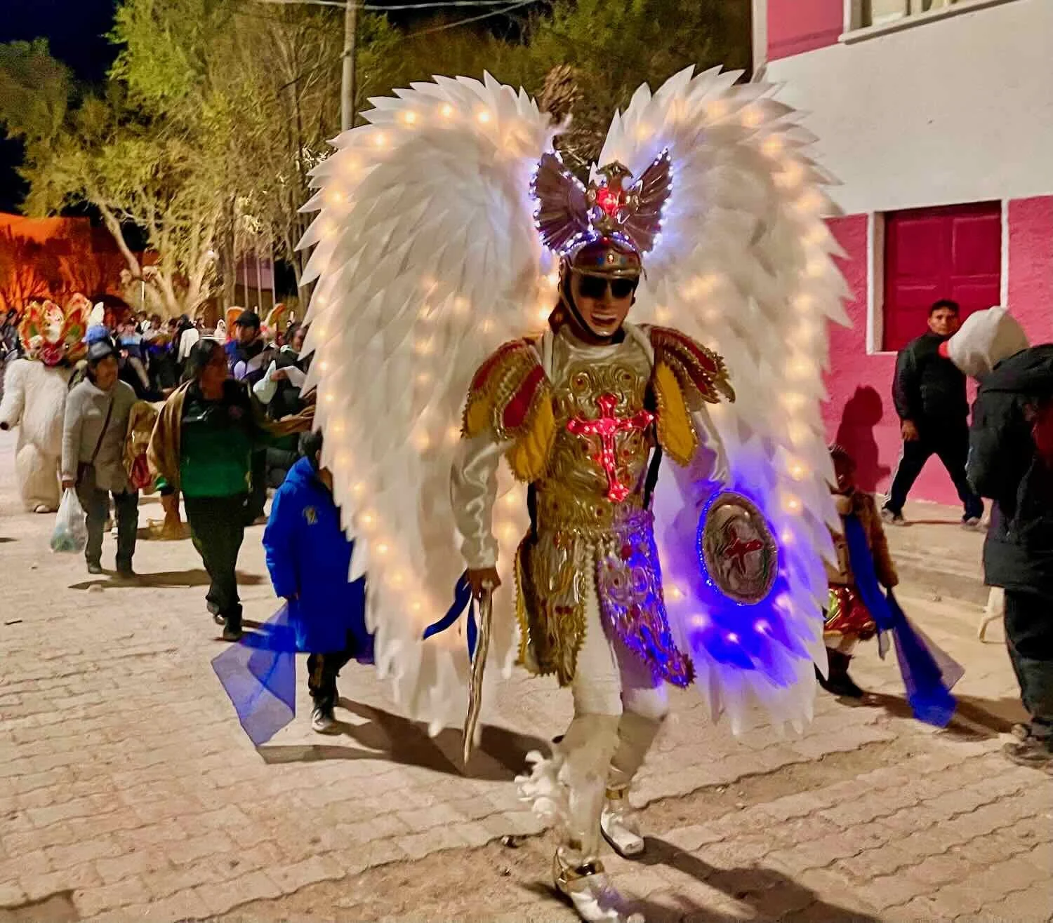
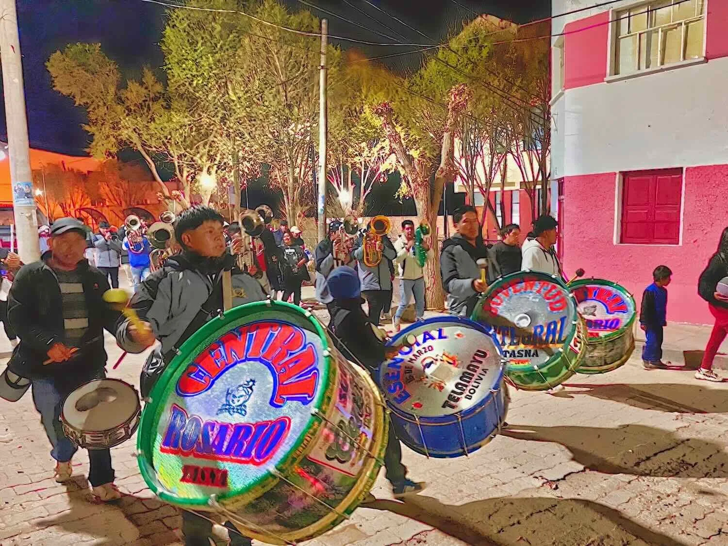
We arrived in Atocha on a Sunday. That evening after dark we heard a marching band approaching while we were in our hotel room. Curious, we went downstairs to see what was happening. As we emerged from our hotel a small procession passed by, led by a guy dressed up as the Archangel Michael, complete with sword, shield, large white wings, and glittering lights. He was followed by a crowd of diabla dancers with devilish masks and fluffy, white bodies, and then the marching band. It was not a big group, but it was fun to see a nighttime parade.

Among the otherwise run-down buildings of the town, our hotel stood out for being fairly new and modern. During our stay, we got to know our exceptional hosts, Miguel and Luci. Both of them were natives of Atocha, but Miguel had worked as an engineer in the United States for many years, and spoke excellent English. When he retired, he decided to return to his home town in the mountains of Bolivia. Upon his return, he came to the conclusion that the town was really in need of a good quality hotel. So he went to work building one. He had hopes of attracting more people to Atocha.
However, Luci was the one who interacted with us the most. In particular, she was aware of the limited dining options in Atocha and offered to prepare breakfast, lunch and dinner for us. Best of all, as Miguel said, she was a very good cook. So we were treated to awesome meals that included stir-fried vegetables, lentils and rice, a variety of meats and eggs, and ‘special smoothies’ made with fresh banana, milk and spices like cinnamon. It all felt wonderfully nutritious after subsisting mainly on chicken and French fries since leaving Villazón.
Posing with our hosts, Miguel and Luci, in front of the Hotel Atocha Inn. It was a modern and comfortable hotel, which was a great find in such a remote mining town. Atocha, Cordillera de Chicas, Potosí Department, Bolivia. Copyright © 2019-2025 Pedals and Puffins.
Return to the Altiplano
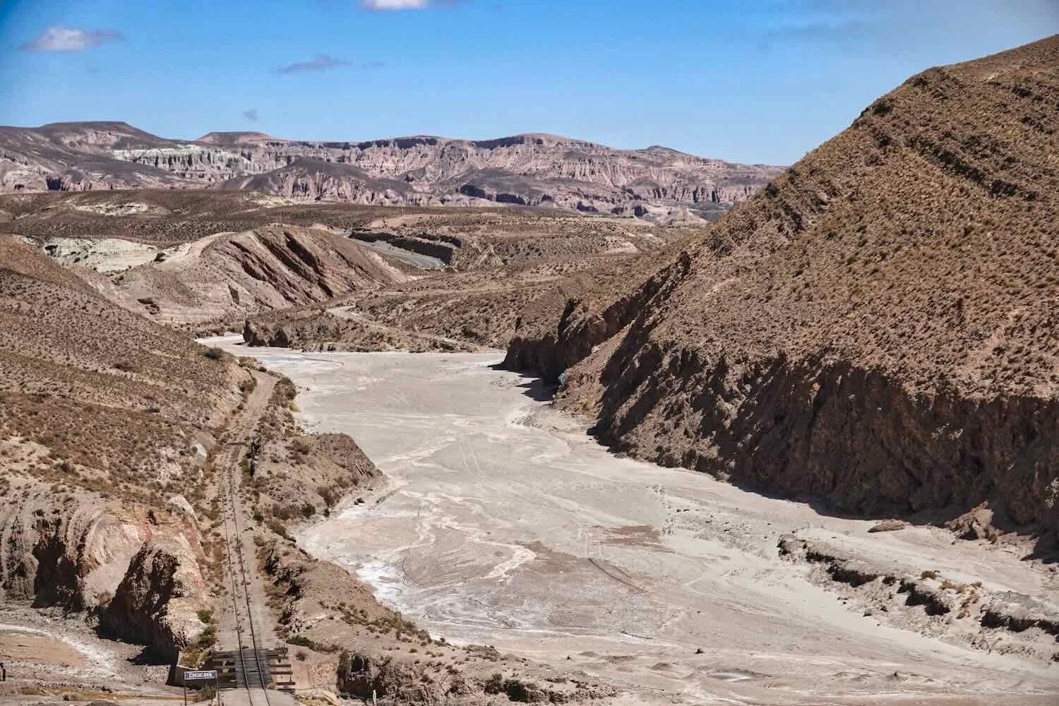
The day of our departure from Atocha we would eventually make our way out of the Cordillera de Chicas mountains and return to the relatively mellow hills of the altiplano. But not before we crawled over one more big ridge. For the first four hours of our ride we cycled over a continuous series of minor ridges that rose steadily upwards through rugged canyonlands. On our right, the broad, gravelly floodplain of the Santa Ana Ravine followed our path.
Cycling through the canyonlands north of Atocha, Cordillera de Chicas, Potosí Department, Bolivia. Copyright © 2019-2025 Pedals and Puffins.
Stopping to re-hydrate among the arid hills of the Cordillera de Chicas. N of Atocha, Potosí Department, Bolivia. Copyright © 2019-2025 Pedals and Puffins.
Making our way towards the big, mountain pass of the day. N of Atocha, Potosí Department, Bolivia. Copyright © 2019-2025 Pedals and Puffins.
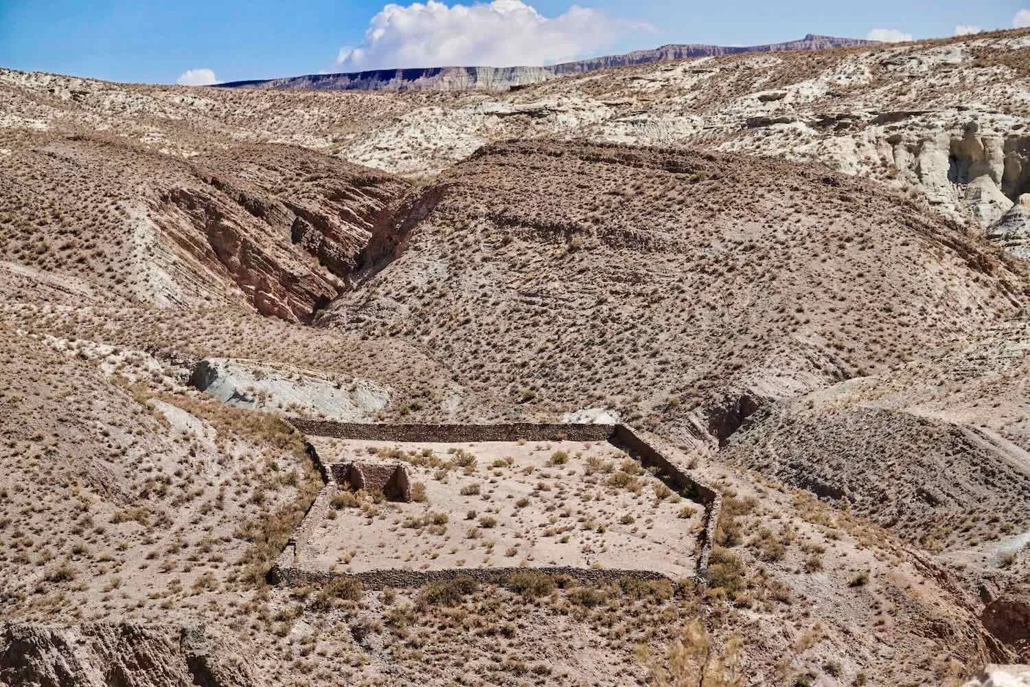
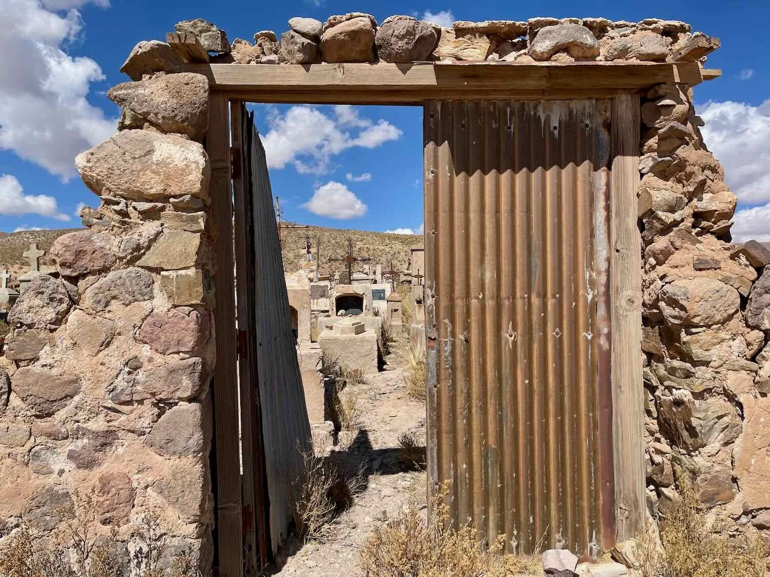
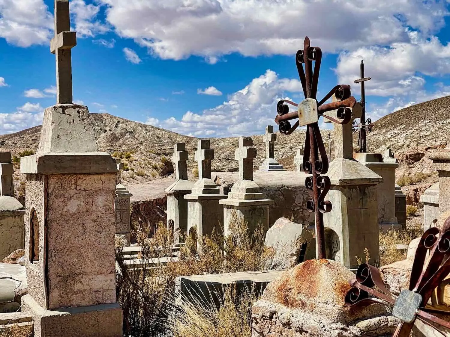
Along the way we passed one of the most evocative cemeteries we had ever seen. Situated on top of a hill overlooking the valley below, the cemetery was crowded with unkempt graves marked by small concrete headstones, nearly all in the shape of a church tower. The headstones were then topped with cast iron crosses, many of which were quite elaborate. The entire scene was both serene and a little bit spooky. Since there were no towns nearby and only a few abandoned homes and mines, we imagined that the area may once have been a little more prosperous, with the graves belonging to people who died in the mines, or from a now abandoned town. People in this area all seemed to be living on the brink, either trying to scape by raising llamas or working in the mines.

The final climb to the top of the pass. N of Atocha, Potosí Department, Bolivia. Copyright © 2019-2025 Pedals and Puffins.
View of the canyonlands from the top of the pass, with the Cerro Chorolque peak in the distance. N of Atocha, Potosí Department, Bolivia. Copyright © 2019-2025 Pedals and Puffins.
The descent from the top of the pass was painstakingly slow, partly because the gradient on that side of the mountain was much more gentle. But the big factor was that we were now battling a fierce headwind, with gusts around 35 mph (55 kph). So what should have been an easy glide to the end turned out to be a lot more difficult than we had hoped.
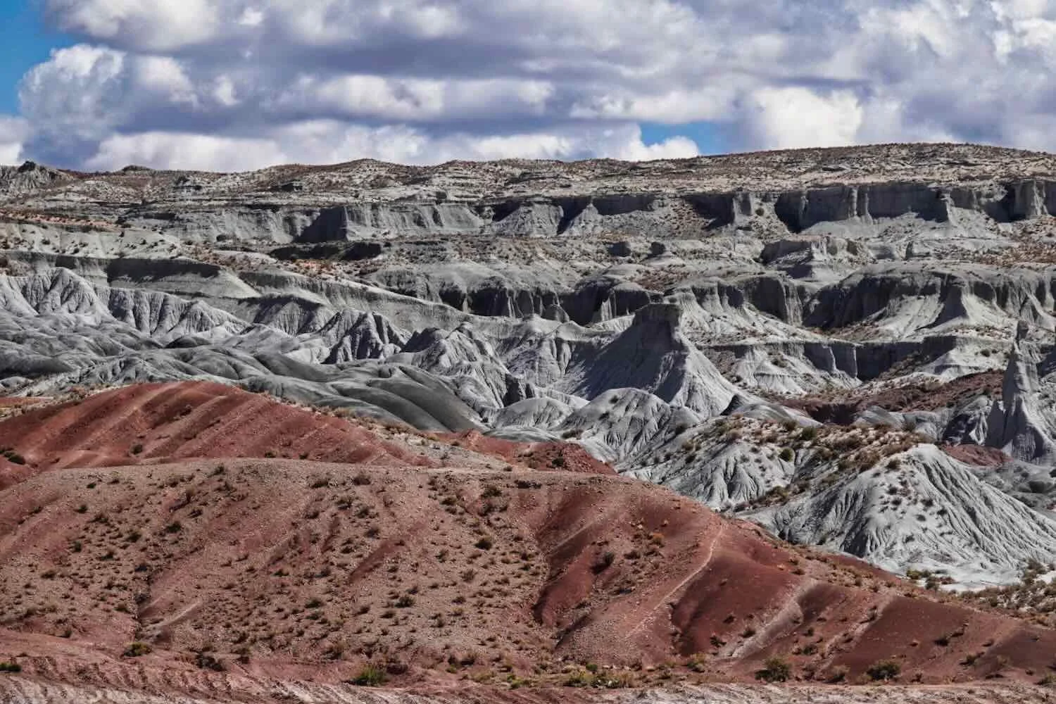
Along with the surprisingly gentle gradient, the landscape on the far side of the pass was completely different as well. The red and beige rock formations were replaced by dusty flats, punctuated by occasional, high altitude sand dunes.
As we descended out of the Cordillera de Chicas mountains, the landscape became much flatter, with sandy soil. N of Cerdas, Potosí Department, Bolivia. Copyright © 2019-2025 Pedals and Puffins.
Somewhere on the descent we crossed paths with another cyclist named Edison He was traveling solo, having started from his home town in a suburb of Bogotá, Colombia. He was hoping to make it all the way to Ushuaia, Argentina. Near Cerdas, Potosí Department, Bolivia. Copyright © 2019-2025 Pedals and Puffins.
A Lesser Rhea strolled across the plain. N of Cerdas, Potosí Department, Bolivia. Copyright © 2019-2025 Pedals and Puffins.
The Rhea was right near the highway sign. N of Cerdas, Potosí Department, Bolivia. Copyright © 2019-2025 Pedals and Puffins.
As the terrain leveled out onto the altiplano, some large sand dunes appeared. Cerdapampa, Potosí Department, Bolivia. Copyright © 2019-2025 Pedals and Puffins.
It looked like the highway department had a problem with sand dunes blowing out onto the road. Some workers apparently abandoned their shovels and wheelbarrow. Perhaps they were tired of losing the battle to keep the sand off the highway. Tolapampa, Potosí Department, Bolivia. Copyright © 2019-2025 Pedals and Puffins.
As the clock turned past 4pm, we grew weary of fighting the wind and started searching for a place to camp. We followed a lightly-used, sandy track into a large, llama pasture. Since there was hardly any topography or vegetation to provide us with cover, we simply followed the track far enough from the highway to be inconspicuous. Before long we were cycling among groups of nervous llamas. Unlike cows, llamas are very aware of their surroundings and cautious, generally trying to avoid people as much as possible. We even spotted a small group of wild vicuñas, who were even more shy than the llamas.
Looking for a place to spend the night, we followed a sandy track away from the highway - far enough not to attract any attention from passing motorists. Tolapampa, Potosí Department, Bolivia. Copyright © 2019-2025 Pedals and Puffins.
Most wild vicuñas we had seen were very shy. But this one (near the place we would camp) seemed almost curious about the odd humans who weren’t sticking to the highway. Tolapampa, Potosí Department, Bolivia. Copyright © 2019-2025 Pedals and Puffins.
Dust In the Wind
By the time we had pitched the tent and laid out our gear inside it was 5:15pm. We got right to work eating dinner and getting ready for bed, since darkness would soon be upon us. But in the time it took for us to finish our sandwiches, the sun had set and the wind accelerated to over 30 mph (50 kph). In the fading light, we could see the air around us becoming a dingy brown color as the wind whipped up dust and sand from the unprotected earth and nearby sand dunes. Furthermore, we were almost completely surrounded by storm clouds and rain. One bright spot was that the combination of dust in the air and cloudy skies made for a stunning, orange sunset.
The dust particles in the air, blown up by a fierce wind over the altiplano, turned the sky a vivid orange during the sunset. In this photo, you can see the wind buckling the right side of our tent as it gusted to over 30 mph (50 kph). Tolapampa, Potosí Department, Bolivia. Copyright © 2019-2025 Pedals and Puffins.
Without any wind protection on the open grasslands, we did our best to tie down the tent as much as possible. Just before turning in for the night we added one more extra guy line (for a total of eleven), and tightened up all of the remaining lines. That turned out to be a good move.
Inside the tent it felt wonderful to be out of the increasingly cold wind. Exhausted from the day’s effort, we both just bundled up and got into our sleeping bags. Meanwhile, the wind roared across the open landscape for the next 2.5 hours. Lightning flashed in the distance, and a few big raindrops slammed against our tent as the storm passed overhead.
Fortunately, all the extra tie downs held secure, so the tent didn’t rattle and sway nearly as much as it had on our first night in the Cordillera de Chicas. We felt well protected. Eventually the wind died down, and a soothing calm settled over the plateau. After that, it stayed quiet for the rest of the night.
Happily, the morning dawned clear and calm. However, everything inside our tent was dusted with a layer of sand, like powdered sugar on a donut. We had tried to pitch the tent low enough to keep the wind out, but clearly it wasn’t sufficient and sand had blown in somehow. We ended up spending a bunch of time sweeping out the sand before taking down the tent.
The next morning the air was clear, giving us a glimpse of the distant Andes mountains to our west. Tolapampa, Potosí Department, Bolivia. Copyright © 2019-2025 Pedals and Puffins.
Back at the highway, the maintenance crew was busy clearing away the sand dunes that had blown across the road over night. Tolapampa, Potosí Department, Bolivia. Copyright © 2019-2025 Pedals and Puffins.
As we headed towards the city of Uyuni, the landscape changed again. Before long we were cycling past mud flats covered with grassy stubble no more than an inch high, or crusted with a thin layer of white salt. The highly-reflective, white surfaces created a mirage effect, so the land near the horizon looked like it was covered with water (although it was not). This seemed to be a favorite landscape for llamas and wild vicuñas - there were numerous, big herds of both species.
A group of llamas marched across an old, abandoned bridge over a broad, dry river bed. It was probably easier than trying to wade through the deep sand in the channel. S of Uyuni, Potosí Department, Bolivia. Copyright © 2019-2025 Pedals and Puffins.
On the barren mud flats south of Uyuni we saw more, large herds of wild vicuñas than anywhere else on our journey so far. S of Uyuni, Potosí Department, Bolivia. Copyright © 2019-2025 Pedals and Puffins.
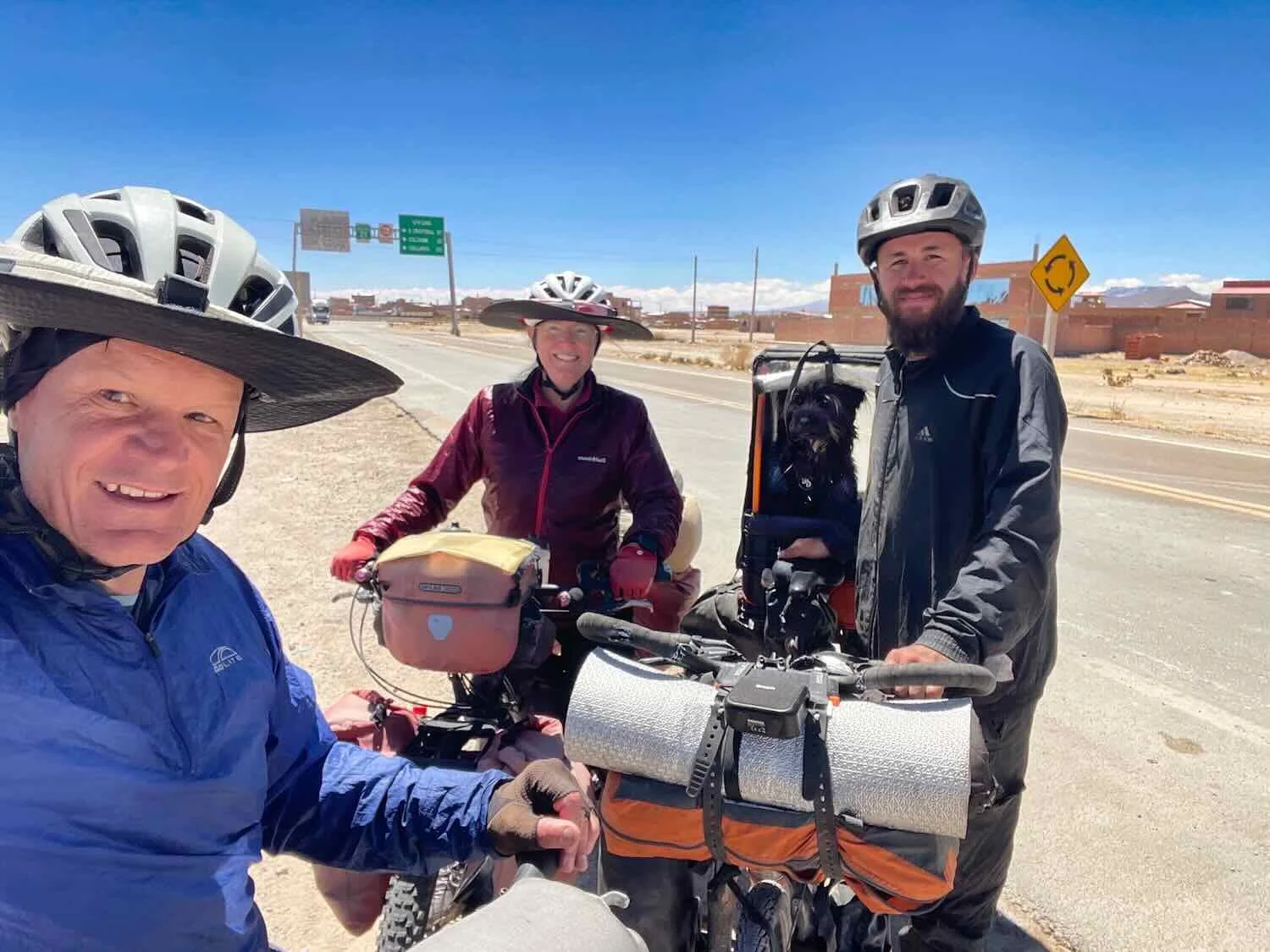
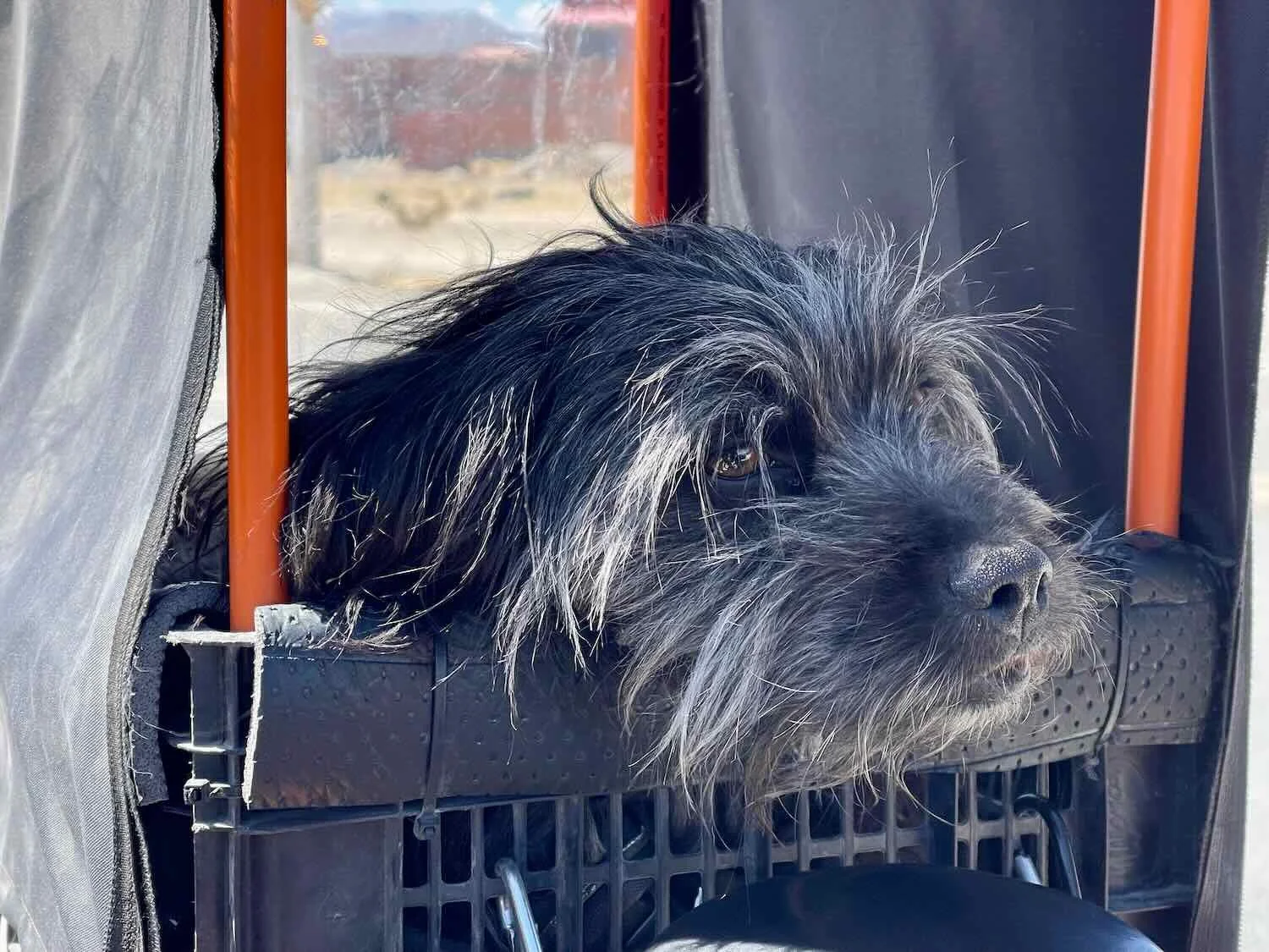
Right on the edge of the town of Uyuni we met another cyclist heading in the opposite direction. Carlos was from southern Brazil. He had cycled across Uruguay, northern Argentina and Chile, and was now heading back towards Brazil. To our surprise, he was also traveling with a dog (but just one, not a whole pack like Guillermo and Sofía). His companion, named Sombra (shadow), was very docile and sat quietly inside his personal palanquin mounted on the back of Carlos’s bike.
Just like the others, Carlos had adopted Sombra on his journey through Brazil. In fact, he joked that Sombra had adopted him rather than the other way around because he hadn’t wanted to get a dog, but Sombra keep following him around “like a shadow,” until it melted his heart. Since then, Sombra had become the star of Carlos’s Instagram account, with almost all of his content focusing on the dog, rather than himself.
It is not easy to travel with a dog on a bike. So despite the fact that we had recently encountered it twice, it is not very common. Perhaps all the attention the cycling dogs get on instagram will make it more popular. And with all the stray dogs looking to adopt a kind human in many parts of the world, a lack of dogs certainly would not be a limiting factor.
Gateway to the Salt Flats
We spent the next few days hanging out in Uyuni (pop. 35,300), the primary hub for people visiting Bolivia’s famous salt flats - the most popular tourist destination in the country. Most visitors are young adventure travelers from Europe, partly because it is easier and less expensive for Europeans to visit Bolivia (requiring just a simple tourist permit) than it is for Americans who must apply for an expensive and difficult to obtain visa (see this link for a description of our ordeal).
Part of the reason why it was more difficult for United States citizens to visit was because over the previous 20 years or so Bolivia had become a socialist country, and as a result did not look favorably on the United States. Yet socialism eventually led Bolivia toward greater economic distress rather than less. Recent elections seemed to indicate that people were fed up with socialism since the only two presidential candidates to make it to the runoff election both wanted to take the country toward a more market based approach. Both candidates promised to revive the economy and develop closer ties with the United States. Bolivians that we met were hopeful that things would now change for the better.
We had three main goals while in Uyuni: (1) resting and continuing to acclimate to the altitude; (2) extending our visas; and (3) visiting the Salar de Uyuni (the world’s largest surface area covered with salt).
The town of Uyuni owes its existence to its historical role as a railroad hub for minerals being shipped from Bolivia to the Pacific Coast. Thus railroad-themed artifacts could be found on display all over town. Uyuni, Potosí Department, Bolivia. Copyright © 2019-2025 Pedals and Puffins.
A German-style clock tower dating to the town’s railroad era sat at one end of Arce Avenue, in the pedestrian-only tourist district. Uyuni, Potosí Department, Bolivia. Copyright © 2019-2025 Pedals and Puffins.
How many mattresses can you load into a vehicle that is not even a truck? This over-sized stack of mattresses seemed emblematic of the town’s critical role as an overnight stop for tourists visiting the salt flats. Uyuni, Potosí Department, Bolivia. Copyright © 2019-2025 Pedals and Puffins.
On the fourth day we finally got out to see the Salar de Uyuni salt flats. It’s possible to bicycle across the flats, and many people do. However, the winds blow with incredible strength out of the north. As a result, nearly everyone who bikes across the salt travels from north to south, with a big assist from a tailwind. (Guillermo and Sofía did it, and told us they flew along at more than 25 mph (40 kph)). Unfortunately, since we were going north, we were faced with the prospect of strong headwinds slowing us down on the desert-like flats. In addition, since our bikes are made from steel - and steel and salt do not mix well - we were concerned about the lack of a place to wash our bikes after traveling over the salt. After thinking it over, we decided that we would enjoy the experience more if we just joined a tour group to visit one of the saltiest places in the world.
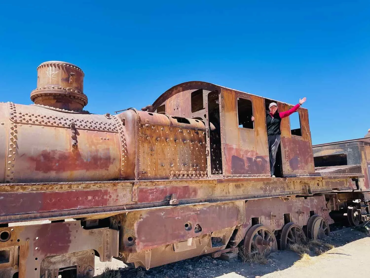
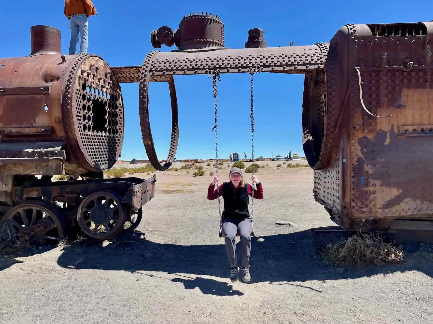
The tour began with a visit to an unusual place called the Train Cemetery. As mentioned above, from the late 1800s through the early 1900s, Uyuni was a critical railway junction for shipping Bolivia’s mineral wealth to ports on the Pacific Coast. British companies built railroad lines across southwestern Bolivia, and imported state-of-the-art steam engines to support the expansion of this once-lucrative business.
But by the 1940s, the mining industry had collapsed. As Bolivia’s ambitious dreams faded, many of the trains were simply left to decay on the outskirts of town. Over time, the salt-laden wind corroded their hulls, and their iron wheels sank into the soft earth - leaving an eerie collection of skeletal remains that only whisper of Uyuni’s early mineral wealth.

Next we stopped in the village of Colchani, which sits right on the doorstep of the salt flats. In fact, Colchani’s economy has been closely entwined with salt mining since well before the arrival of the Spanish - when llama caravans would carry salt from Colchani to inland regions that did not otherwise have access to the resource. These days, the Salar de Uyuni salt flat is home to Bolivia’s largest salt mining cooperative, whose members still extract blocks of salt by hand and refine it using traditional methods. During a quick stop at the Colchani Artisan’s Market, we were able to learn a little bit about the mining and refining processes.
Our guide showed us different types of salt blocks, which are cut directly from the surface of the salt flats. Most are ground down for culinarily or industrial use. But others are kept as blocks that can be used in construction like bricks. The wall in the background is made of salt. The problem with using salt as a building material is that it dissolves in the rain, and this leads to a frequent need for repairs. Artisan’s Market, Colchani, Potosí Department, Bolivia.Copyright © 2019-2025 Pedals and Puffins
Of course, you could buy all manner of souvenirs made from salt at the Artisan’s Market. Colchani, Potosí Department, Bolivia. Copyright © 2019-2025 Pedals and Puffins.
However, the real star of the tour was the Salar de Uyuni salt flat itself. It is the world’s largest concentration of salt, covering 4,086 square miles (10,582 sq km), which is roughly the size of the island of Puerto Rico. In its center, the salt layer can reach depths of more than 33 ft (10 m), and it contains an estimated 10 billion tons of salt. Yet the surface is so flat that NASA (the US space agency) has used it to calibrate satellites.
We spent the rest of the day venturing out onto the giant, white desert in a SUV that was doing pretty well considering it spent its days driving through salt. Our guide said that the vehicles are washed a minimum of every couple of days and still only last a couple of years before they have to be completely rebuilt. When the chassis corrodes away the mechanics buy a replacement, then reuse the same motor and body which they place on the new chassis. Sometimes the new chassis is from a different model car resulting in a kind of Frankenstein car.
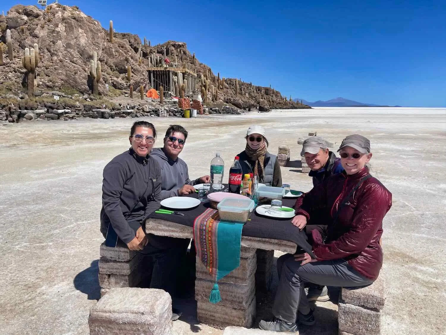
In addition to marveling at the huge expanse of the salt flat itself, we:
ate lunch at a salt-block, picnic table,
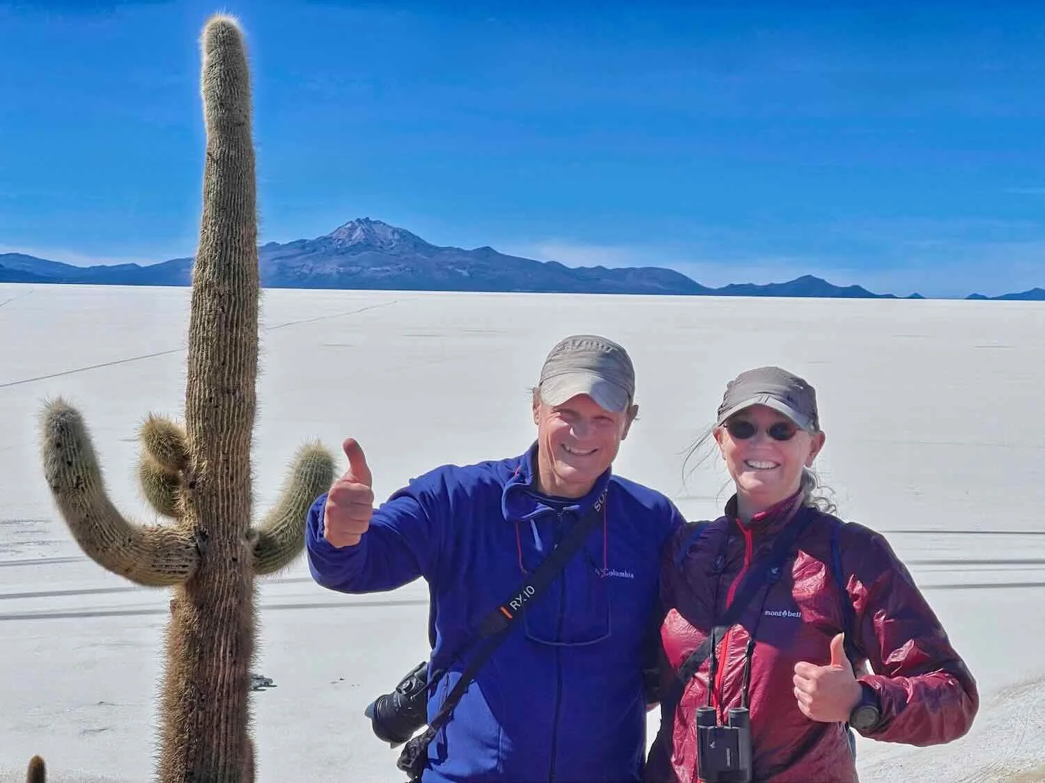
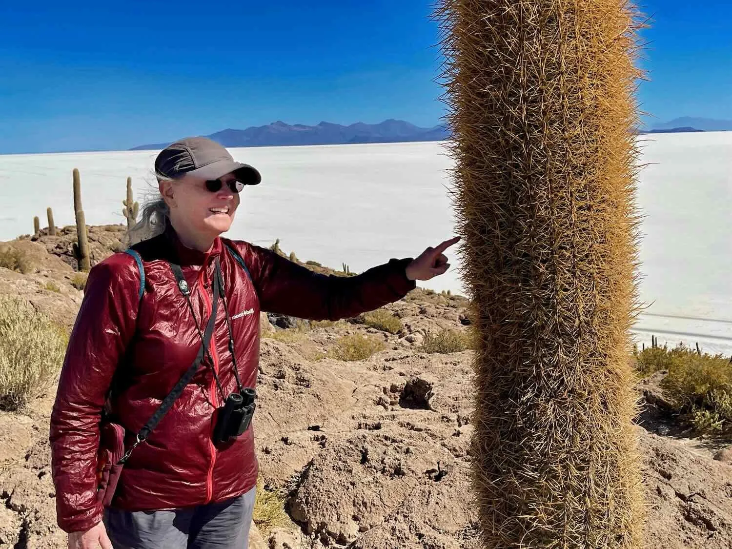
hiked to the top of one of the “islands” that rose from the depths of the now-evaporated, inland sea, where we had a panoramic view of the mountains surrounding the salt flat,
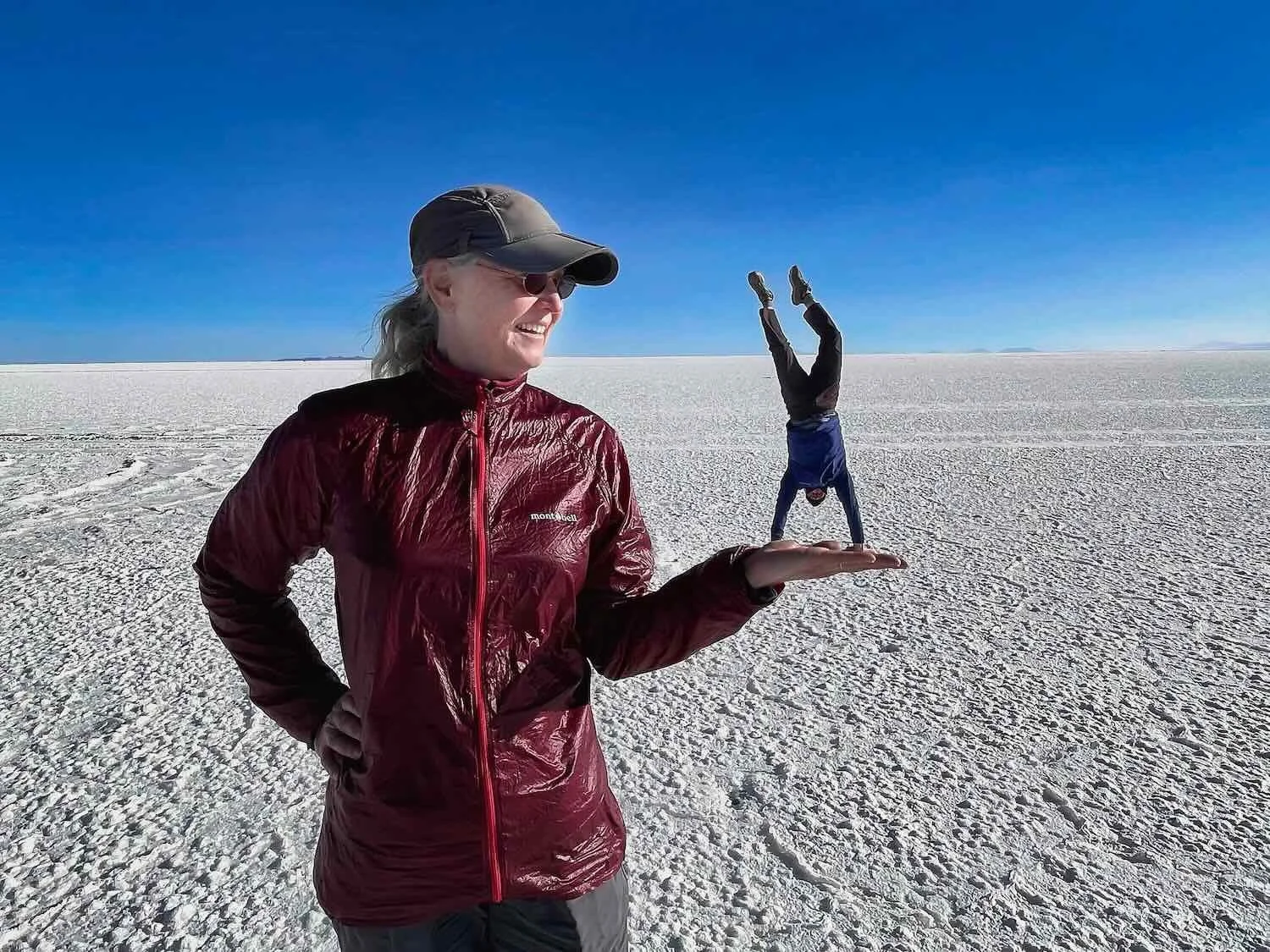
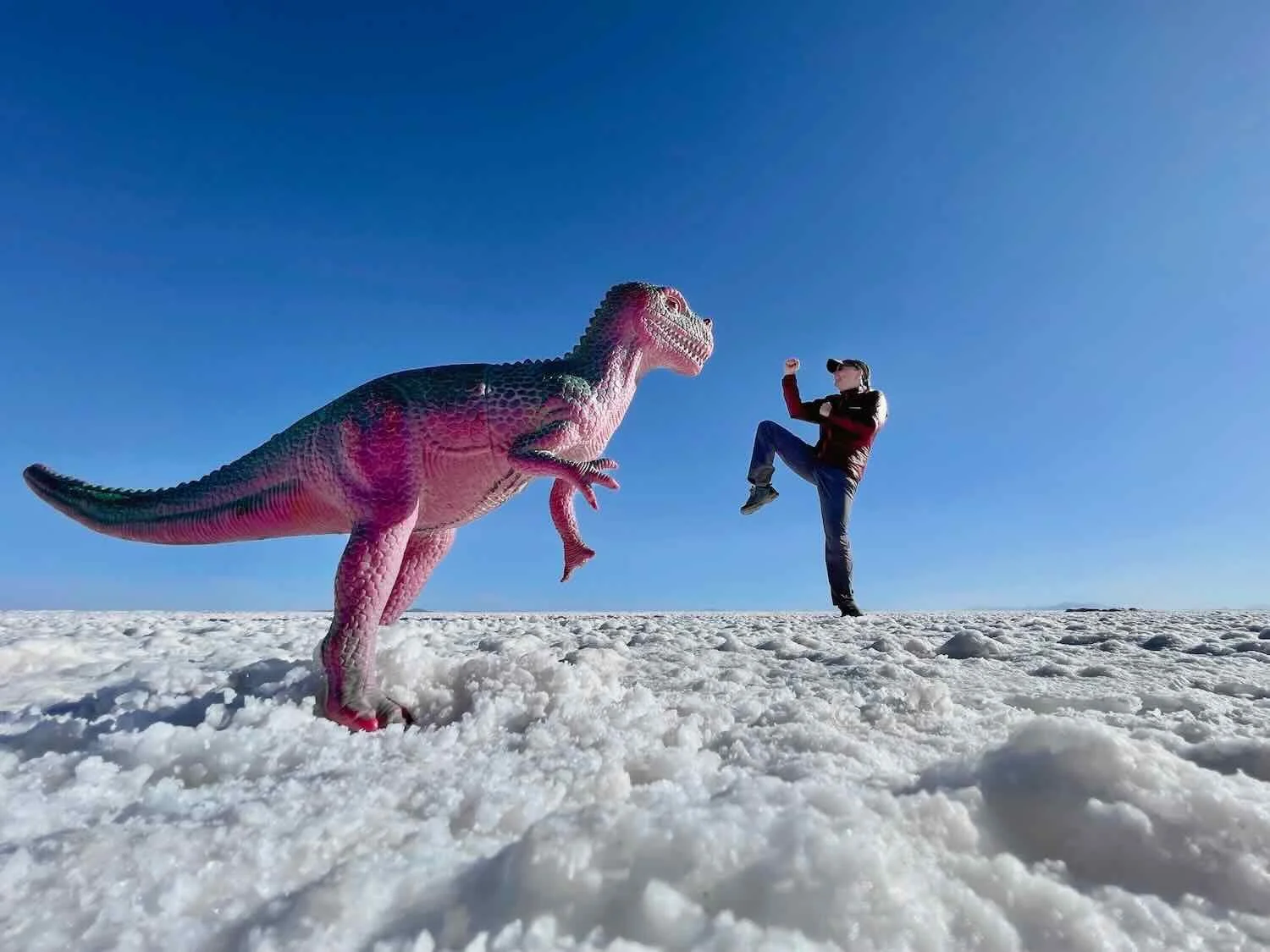
took some fun photos that used the vast, featureless landscape to play tricks with perspective,
visited the first hotel built entirely with salt bricks (now a museum, after two new salt hotels were built)
enjoyed the sunset over a part of the salt flat that was covered with a thin sheen of water, creating mirror-like reflections in the shallow lake.
Here are some photos from our visit to this magical place.
This sign let us know that we were about to leave the regular world behind, and enter the great, white desert of the Uyuni Salt Flats. Potosí Department, Bolivia. Copyright © 2019-2025 Pedals and Puffins.
The salt flat is so huge and featureless that it could be hard to judge distances. Objects were often farther than they appeared. Uyuni Salt Flats, Potosí Department, Bolivia. Copyright © 2019-2025 Pedals and Puffins.


A strong northerly wind whipped the flags in the Plaza de las Banderas. People can bring their own flag and add it to the collection. (We were glad not to be cycling into that headwind.) Copyright © 2019-2025 Pedals and Puffins.
A clock constructed from blocks of salt, inside the common room of the first all-salt hotel in Bolivia (now a museum). Uyuni Salt Flats, Potosí Department, Bolivia. Copyright © 2019-2025 Pedals and Puffins.
A thin layer of water atop the hard-packed salt was so still and smooth that it was as reflective as a mirror. Uyuni Salt Flats, Potosí Department, Bolivia. Copyright © 2019-2025 Pedals and Puffins.
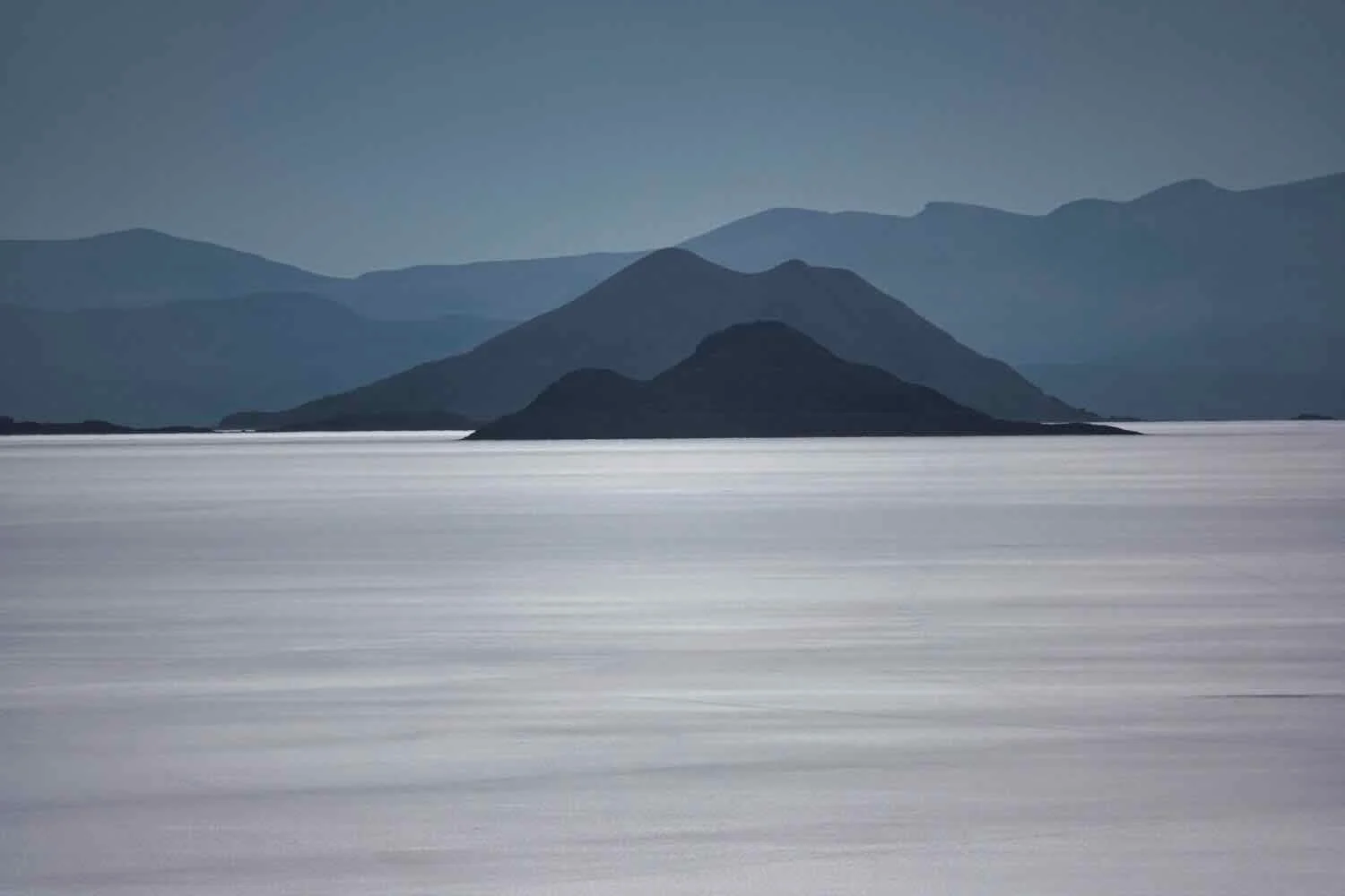
A distant vehicle traversed the salt flats, with the dormant Tunupa Volcano in the background (more than 50 miles away). Uyuni Salt Flats, Potosí Department, Bolivia. Copyright © 2019-2025 Pedals and Puffins.
Capturing the sunset - a perfect end to the day. Uyuni Salt Flats, Potosí Department, Bolivia. Copyright © 2019-2025 Pedals and Puffins.