Cycling Argentina’s Route 40, Part 3: Mendoza to Chilecito
23 May - 2 July 2025
23 May - Mendoza to Tres de Mayo (21.6 mi, 34.8 km)
24 May - Tres de Mayo to Media Agua (53.0 mi, 85.3 km)
25 May - Rest Day in Media Agua
26 May. - Media Agua to San Juan (34.4 mi, 55.4 km)
27 May-14 June - Sick Days in San Juan
15 June- San Juan to Río Travesía Wild Camp (36.0 mi, 58.0 km)
16 June - Río Travesía Wild Camp to Refugio Doña Mariana Wild Camp (32.8 mi, 52.8 km)
17 June - Refugio Doña Mariana Wild Camp to San Roque (26.8 mi, 43.1 km)
18-19 June - Rest Days in San Roque
20 June - San Roque to Wild Camp N of Huaco (39.5 mi, 63.6 km)
21 June - Wild Camp N of Huaco to Guandacol (33.0 mi, 53.1 km)
22-23 June - Rest Days in Guandacol
24 June - Guandacol to Villa Unión (28.7 mi, 46.2 km)
25 June - Villa Unión to Los Tambillos (31.7 mi, 51.0 km)
26 June - Los Tambillos to Miranda (17.6 mi, 28.3 km)
27 June - Miranda to Chilecito (20.1 mi, 32.3 km)
28 June-2 July - Weather Layover in Chilecito
Leaving Mendoza
Getting specialized bicycle parts sent to us from outside Argentina always required a lot of time. Shipping takes weeks, clearing customs can take another week or more, and getting parts installed takes time. These things, combined with other delays, meant that we could get held up by 3-4 weeks just to to get a necessary bicycle part replaced. As we described in detail in our previous post, this was the case in Mendoza. We’d spent a full month in Mendoza and we were now looking forward to getting back on the road.
In the end we were pleasantly surprised by the relative ease with which we were able to cycle the 6 miles (10 km) from where we stayed in Mendoza out to the northern edge of town, aided by Mendoza’s extensive network of bicycle lanes.
We passed a big circus complex on our way out of the city. Route 40, City of Mendoza, Mendoza Province, Argentina. Copyright © 2019-2025 Pedals and Puffins.
However, the cycling got trickier once we reached the edge of the city. The highway between the cities of Mendoza and San Juan ended up being one of the busiest stretches of road that we would travel in Argentina. Mendoza and San Juan are the capitals of neighboring provinces, with bustling economies and large populations. And on any given day, it seems as if a lot of those people have business that takes them on Argentina’s Route 40 for the three hour drive from one city to the other.
On top of that, nearly the entire length of Route 40 between Mendoza and San Juan - a distance of about 100 miles (160 km) - was under construction. It’s being expanded it into a four-lane highway (up from one lane in each direction), and all the water crossings are being replaced with modern bridges and culverts.
It’s a huge project, and it has been fraught with problems. Construction began in 2018, but within a couple of years the original contracts were cancelled due to lack of progress. The work was re-started in 2023-24 with new contractors, and some sections of the highway are scheduled to be completed by 2027. But there are other sections for which construction has been ‘paused’ indefinitely, even where parts of the highway had already been torn up by the original developers. Needless to say, the road conditions weren’t great for such a busy transportation route.
Most of the time the vehicle traffic was confined to two, narrow lanes (one in each direction), making it extremely challenging to cycle on the main, paved road. Fortunately the rough, gravel margin was generally wide enough for safe cycling. But the real bonus was that for long stretches there was a parallel track where construction had begun on extra lanes, but had been abandoned. These half-completed roads were closed to vehicle traffic, free of construction crews, and available to cycle on.
As a result, we could cycle away from the busy highway. These partially completed roads were largely covered with smooth, hard-packed gravel, but sometimes they were fully paved. It was awesome whenever we had a paved road all to ourselves. Unfortunately, none of the bridges were complete, which required some special maneuvers to get around. But in spite of the conditions, we made reasonably good time.
A Town Named for a Birthday
It was late afternoon when we rolled into the small, agricultural community of Tres de Mayo (pop. 1,400). Given Latin Americans’ proclivity for naming roads, landmarks and towns after famous dates of national importance, you might expect Tres de Mayo to refer to the date of an important battle, national proclamation, or other significant event.
But the truth is more unconventional. Apparently for many years in the mid-1800s, the owner of the land would celebrate his wife’s birthday each year with a giant party, which would attract hundreds of people from throughout the region. As the years passed, her birthday (3 May) became synonymous with the location of the estate - and was later adopted as the name of the town founded upon its site.
Surprisingly for a town of its size, there weren’t any restaurants or cafeterias in Tres de Mayo. So once we had settled into our little cabin, we walked a mile down the road to the one, modest grocery store to buy some food for dinner. Along the way we passed the impressive Tres de Mayo Wine Cooperative, with its long row of giant wine storage tanks. For the past 60 years the cooperative has gathered grapes produced by the area’s many small vineyards, and managed the process of producing wine under the Tres de Mayo label.
This row of massive storage tanks was not for holding oil or water - but for storing the grapes produced by members of the Tres de Mayo Wine Cooperative before they were turned into wine. Colonia Tres de Mayo, Mendoza Province, Argentina. Copyright © 2019-2025 Pedals and Puffins.
Although our cabin was small (we just managed to squeeze the bikes inside), it had only one, weak heater and the windows were not very well insulated. The heater was in the bedroom, which provided a bit of warmth for sleeping. However, that didn’t help much in the rest of the cabin. Even with the heater running full steam all afternoon, the kitchen/dining area and bathroom remained cold enough that we had to wear multiple coats to be comfortable. We both slept in our long johns under multiple wool blankets, and stayed just warm enough.
When we emerged from the frigid cabin in the morning it was already warmer outside than inside the cabin, even with the heater running all night. The layer of gray smog that had hung over us throughout the previous day was gone, revealing a stunning view of Mount Aconcagua peeking over a dark, lower ridge. At 22,835 ft (6960m) Mount Aconcagua is the highest mountain in the world outside of Asia. On this day it was frosted with a bright, white dusting of snow - much more snow than we had seen previously. We were glad we had already crossed the Andes mountains from Chile, and wouldn’t have to worry about snow-covered passes as the winter approached.
Mount Aconcagua, the highest mountain outside of Asia, glowed in the distance to our west. Route 40, Villa Tulumaya, Mendoza Province, Argentina. Copyright © 2019-2025 Pedals and Puffins.
Closer at hand, the landscape was covered with a jumble of scruffy-looking shrubs, with sparsely-vegetated hills in the background. Route 40, Villa Tulumaya, Mendoza Province, Argentina. Copyright © 2019-2025 Pedals and Puffins.
A sturdy bus shelter in a small, highway town provided a comfortable spot for a rest break. Route 40, Jocolí, Mendoza Province, Argentina. Copyright © 2019-2025 Pedals and Puffins.
Crossing the Bañados
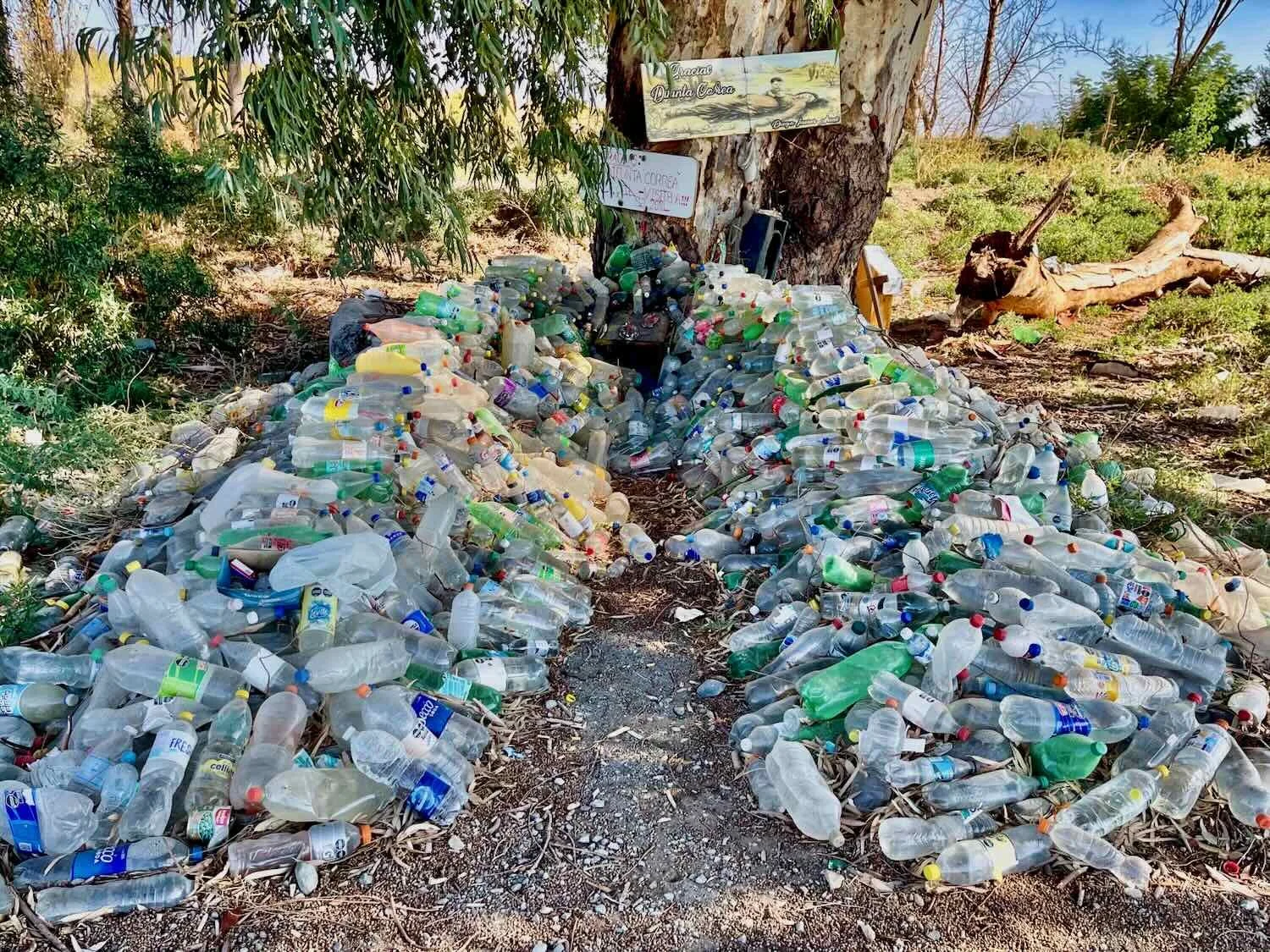
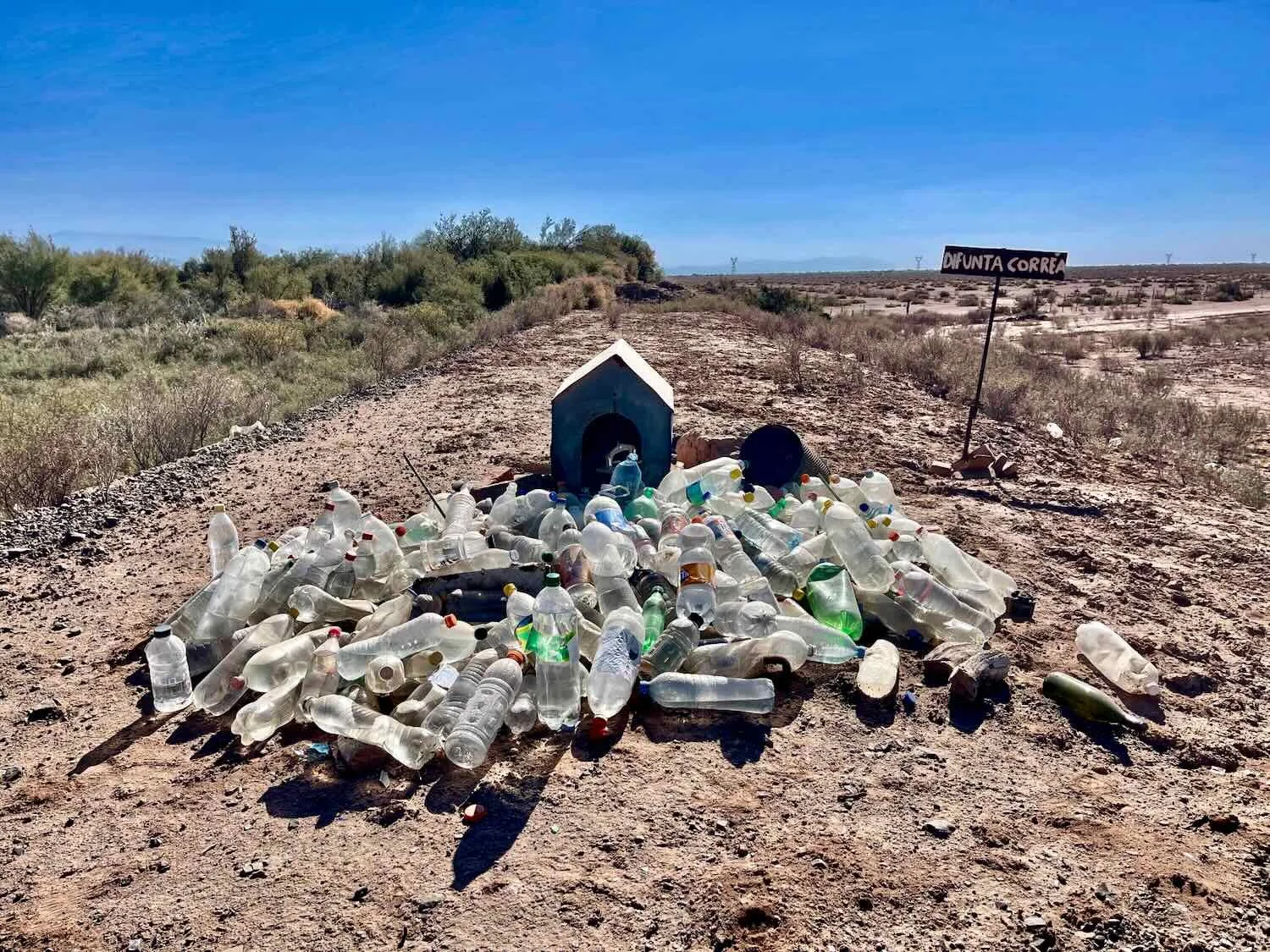
As we made our way north towards the province of San Juan, Argentina, there was a noticeable increase in the number of roadside shrines dedicated to the Difunta Correa - an Argentinian folk saint who is said to have died of thirst while searching in the desert for her ailing husband in the mid-1800s. She is buried in San Juan province, and we were clearly approaching the heartland of devotion to her. One of the key ways her followers appeal to her for protection is by leaving bottles of water at her shrines, to help quench her eternal thirst. We first started seeing these shrines several hundred miles to the south. But here, nearly every one was piled high with dozens, or even hundreds of bottles of water.
Yet perhaps the most remarkable feature of the day’s ride was the crossing of Los Bañados - flat, dusty plains that were completely devoid of vegetation.
Every half mile or so the road would dip into a concrete spillway, with signs warning drivers to use caution when driving through water. That seemed completely out of place, because when we were there the earth was bone dry. But all the evidence indicated that sometimes it must get very wet. When the rains do come, the water apparently spreads out across the plains creating huge, shallow wetlands that they call ‘bañados.’
We cycled across huge, dry mudflats that were completely devoid of vegetation - suggesting they must flood often enough to keep the typical, desert plants from growing there. Route 40, N of Jocolí, Mendoza Province, Argentina. Copyright © 2019-2025 Pedals and Puffins.
There must be water around sometimes. This sign near a dip in the road urged drivers, “Before Crossing Observe Height of the Water.” Route 40, N of Jocolí, Mendoza Province, Argentina. Copyright © 2019-2025 Pedals and Puffins.
It had literally been months since we had seen any significant rain. The dusty soils in the road construction zones were cracked and dry. Route 40, N of Jocolí, Mendoza Province, Argentina. Copyright © 2019-2025 Pedals and Puffins.
Around 3pm we arrived at El Fogón, a small, roadside restaurant. The spot is very well known among cyclists and motorbike travelers for allowing folks to camp next to the restaurant along an otherwise empty stretch of highway. It is so well regarded that we expected to pitch our tent and spend the night there. However, as we rolled up on our bikes, our hearts sank.
It was tiny, with only three tables inside the restaurant. And it was situated right next to a police checkpoint, where passing cars had to stop to have their documents checked. Really, there was no more than 20 ft (6m) between the spot for tents and the police booth.
The friendly lady in the restaurant was happy to let us camp there. But when we asked, she admitted that the road would remain busy, with cars continually stopping at the checkpoint all night. It would certainly be noisy and not restful at all. Furthermore, she told us she was planning to close the restaurant early that night because she was going to a birthday party. We therefore wouldn’t be able to get a warm, evening meal - which was one of the big reasons to camp at the restaurant. In the end it just didn’t seem like we’d get much sleep - or be very comfortable - camping at the restaurant.
We settled in for a late lunch of milanesas (which, if you are lucky, you can get away with eating only once a day in Argentina). Milanesa platters or sandwiches really are the the go-to Argentinian meal, that is served any time, everywhere.
We then considered our options. It was just over 19 miles (31 km) to the next town, where there was a hotel. Using the restaurant’s wifi, we confirmed that there was a room available at the hotel that night - and that sealed the deal. We would cycle the extra 19 miles for a chance to get a good night’s sleep. At least we departed well fed.
By the time we had finished eating it was late afternoon, so we just rode the extra 19 miles at a brisk pace to reach the town of Media Agua (pop. 8,000) just as darkness was setting in. We needn’t have worried about getting a room - we were the only guests at the hotel. This surprised us since it was a weekend and there appeared to be a wedding reception celebration going on across the street.
No other guests in the hotel was convenient for us, though, since our room ended up being too small to fit our bicycles inside. Instead the friendly proprietor just let us store our bikes in another, vacant room for free. Best of all, the room heater worked great, keeping us comfortably warm all night - a nice change from the ice box cabin in Tres de Mayo.
However, the most enduring memory of that hotel was the floor in the hallway. It was covered with the most glossy, black tiles we had ever seen. The tiles were so smooth and shiny that you could have used them as a mirror. Unfortunately, the hotel was located along a dirt road. So every time someone entered, they would track in a bunch of dust - leaving a trail of pale brown footprints wherever they went. Our bike tires left a sinuous trail of dust as well. We tried several times to wipe our feet before walking on the floor but it was no use. It appeared impossible to not leave tracks, no matter how clean the bottom of your shoes.
Whenever the host was around he would grab a perpetually wet mop from the kitchen and walk back and forth along the hall, wiping away the dusty footprints. It was a never-ending job, but that didn’t seem to bother him. He was clearly very proud of his fancy floor, and even asked us at one point - didn’t we think the glossy floor was beautiful? Of course, we said, “yes.” Before long we adopted the practice of using the mop to wipe up after ourselves. It just didn’t feel right to sully that kind man’s pride and joy.
Arriving in The Oasis City
The bike ride from Media Agua to the city of San Juan was better than the previous couple of days. There was still a lot of traffic, and no paved shoulder. But for most of the way there was a paved, parallel roadway that was not yet open to traffic. It was heavenly to have a big, wide, newly paved road all to ourselves.
Cycling along a traffic free section of road that was under construction gave us the chance to stop whenever we wanted to - and observe some of the local wildlife like this Green-barred Woodpecker. Route 40, N of Media Agua, San Juan Province, Argentina. Copyright © 2019-2025 Pedals and Puffins.
A man watched over a roadside brush fire, which he had probably set to clear vegetation. It must have been the ‘burning season,’ because we saw a lot of brush piles set on fire. Route 40, Colonia Fiscal Sarmiento, San Juan Province, Argentina. Copyright © 2019-2025 Pedals and Puffins.

The catch was that it was not a continuous road. The pavement ended at each river crossing, because none of the new bridges had been built yet. Whenever we approached a ditch or water course, we had to cycle along a dirt track back onto the main roadway, cross the bridge on the gravel shoulder, then find our way back onto the paved section under construction. Yet by and large we had great cycling conditions, and rode along at a good pace.
Cycling across the dirt to get back to the main road. Route 40, Colonia Fiscal Sarmiento, San Juan Province, Argentina. Copyright © 2019-2025 Pedals and Puffins.
San Juan Province is still part of Argentina’s wine region. As we approached the capital of the province, the vineyards returned. Route 40, near the City of San Juan, San Juan Province, Argentina. Copyright © 2019-2025 Pedals and Puffins.
Before long we entered the metropolitan zone of the city of San Juan (pop. 550,000). Along the way we passed the impressive Provincial Velodrome - a spiffy, new stadium that was completed in 2023 specifically to host top-tier, international, indoor-track cycling competitions with seating for nearly 6,000 spectators. The design looked very much like a royal crown, with decorative tiles and a diadem of A-shaped beams reaching nearly 100 ft high (30m) that hold up the dome.
We cycled past the handsome, new San Juan Provincial Velodrome - considered to be among the best and most modern velodromes in the world (and probably the top indoor-track cycling venue in Latin America). Route 40, City of San Juan, San Juan Province, Argentina. Copyright © 2019-2025 Pedals and Puffins.
As we cycled onto the city streets, it became obvious why San Juan is known as The Oasis City. Although it is situated within a desert, San Juan has access to abundant mountain runoff water that is delivered throughout the city via a network of canals, much like the City of Mendoza. As a result, the streets of San Juan are lined with tall, leafy, shade trees that provide a green refuge in the otherwise harshly dry region. It was a pleasure to see such luxuriant vegetation again after several days cycling among the thorn bushes and barren flats.
Big, old trees provided a canopy of shade on a typically green street in San Juan. It was pretty clear why they call it The Oasis City. City of San Juan, San Juan Province, Argentina. Copyright © 2019-2025 Pedals and Puffins.
A Longer Than Expected Layover
We had only expected to stay a couple of days in San Juan - just long enough to take care of extending our Argentinian tourist visas for another 90 days. But fate had other plans.
Soon after our arrival in the city PedalingGal came down with a bad case of the flu, including a fever that lasted several days. Two days later, the same illness struck PedalingGuy. In truth, it may have been inevitable that we would get sick. When we were out walking on the street or in a store shopping, people all around us were coughing and sniffling. It seemed as if half the population of San Juan was sick with the flu.
It didn’t help that our Airbnb was directly adjacent to a very busy bus stop. We have become fairly good at sleeping with a lot of street noise, but this was a whole new level, approaching the loudest, most noisy place on earth (or at least that is what it seemed like). After a couple days, we could distinguish particular buses by the sound of their squealing brakes. The buses ran from about 5am until 2am the next day, leaving just a brief, 3-hour window for good, restful sleep. Obviously this was not ideal for two people with the flu. Unfortunately as is typical with Airbnb, our reservations could not be cancelled. So we put up with the noise until our reservation was complete.
Recovery was slow. We ended up extending our stay for two extra weeks, and moving to a different Airbnb in a quieter part of town where we could get the rest that we craved.
The extra time came in handy when the effort to extend our tourist visas took a lot longer than expected. We devoted three full days to the task:
Day 1 - We initiated the process by filling out the appropriate forms at the immigration office and receiving the required papers to take to the bank, for payment of the fee. However, it took us several hours to complete the payment at the bank. By the time we made it back to the immigration office with our proof of payment, the guy who needed to complete the final paperwork had gone home for the day (even though it was an hour before closing time). We were told to return tomorrow.
Day 2 - We returned to the immigration office in the morning, turned in our proof of payment from the bank, and completed the paperwork. But then the immigration officer told us that there was a backup at the main visa processing office in Buenos Aires. As a result, the final document confirming our visa extension wouldn’t be ready until that afternoon. He gave us instructions for how to download the document online, and we went back to our Airbnb. Unfortunately, our documentation never appeared online that evening. We would have to go back to the office one more time.
Day 3 - We made our final trip to the immigration office. When we explained that our document never appeared online, the immigration officer made a phone call to someone to request that they finalize our application (which apparently still had not been completed). Eventually, after about an hour of waiting, we finally got a physical copy of our visa extension document. It was a big relief to know we had another 90 days to make our way to the northern border of Argentina (especially now that we had delayed our departure by two weeks).
Of course, in spite of the illness and visa headaches we did manage to get out and see some of the sights in San Juan. Here are a few photos from our stay in The Oasis City:


Cycling the Heights of Argentina’s High Desert
When we finally rode out of San Juan in mid-June, it took us a while to escape the grip of the city’s urban footprint. But after 1.5 hrs of relatively flat cycling, we emerged into more rural country with hardly any signs of people. The vehicle traffic dropped off dramatically, and we finally were able to cycle on the main highway once again.
One of the last towns we passed through north of the city of San Juan was Villa General San Martín. The entrance to the town was marked by this particularly grand plaza. Route 40, Villa General San Martín, San Juan Province, Argentina. Copyright © 2019-2025 Pedals and Puffins.
Just past Villa General San Martín we left the tall trees behind, and cycled back into the desert. Route 40, N of Campo Afuera, San Juan Province, Argentina. Copyright © 2019-2025 Pedals and Puffins.
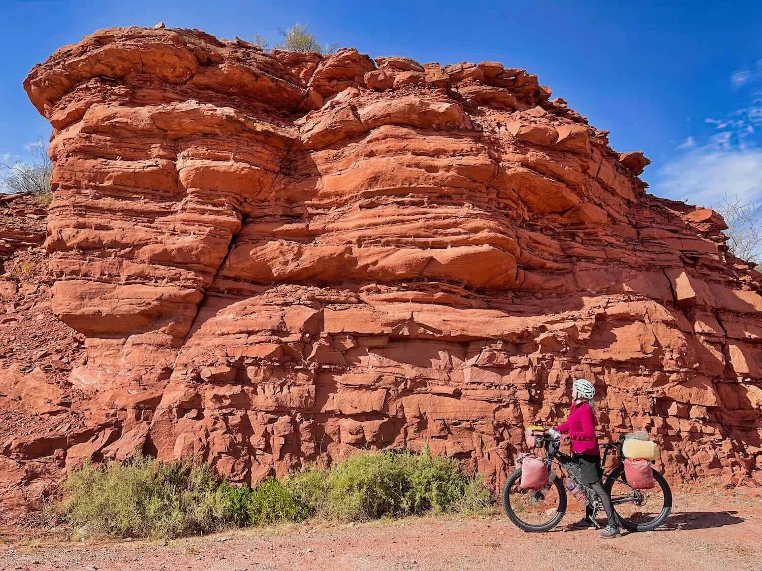
At the edge of the human settlements the land began to rise. Before long we found ourselves cycling up a long, relentless hill that brought us into a high valley between parallel, dusty brown mountain ranges. None of the summits were particularly high. But they marched along in a continuous ridges, sculpted by erosion. It actually felt a bit weird to have mountains on both sides, instead of just on the west. For the past three months the mountains had been almost exclusively on our left side. A few of the slopes had active, underground mines. Later we learned that this area produces a lot of copper, silver and gold.
For the first time in many months, mountain ridges arose on both our right and left hand sides, as we rode uphill into a high valley. Route 40, S of Matagusanos, San Juan Province, Argentina. Copyright © 2019-2025 Pedals and Puffins.
During the 2.5 hour ascent, we crossed into Argentina’s high desert (formally known as the High Monte Desert) - most of which lies 2,000 ft (610m) or more higher than the lowland deserts around Mendoza and San Juan. One of the first things we noticed was that there was a lot more vegetation here. It was still dominated by low, thorny shrubs and cacti. Yet now there were some patches of wild grass and even a few gnarled trees growing taller than a person’s head. Although the high desert is still very dry (with only 4-15 inches of rain a year), it receives almost twice as much precipitation as the parched lowland deserts.
The 2,000 ft (610m) ascent into the high desert would have been tough any day, but it was made harder because we lost a lot of fitness from resting while sick. PedalingGal needed a break to catch her breath. Route 40, S of Matagusanos, San Juan Province, Argentina. Copyright © 2019-2025 Pedals and Puffins.
As the afternoon warmed up, it was nice to have a few, actual trees along the road to provide some shade for a rest break. Route 40, N of Matagusanos, San Juan Province, Argentina. Copyright © 2019-2025 Pedals and Puffins.
It took us three days to cycle from San Juan to San Roque, the next town with services. In between, we camped in the desert by finding lightly-used, dirt side roads and cycling at least a thousand yards from the highway to find a quiet, hidden campsite among the thorn bushes and cacti. The ground was comfortably soft and sandy, and we both slept great in the peaceful desert. PedalingGuy actually remarked that he thought the wild camps in this part of Argentina were some of the best in the world.
On the second day, we flew along at a breakneck speed, assisted by a slight downhill gradient and a miraculous, rare tailwind. Our swift progress gave us time to stop often and enjoy the evolving scenery. The increase in vegetation supported a greater abundance and diversity of birds, including some new species that weren’t present in the lowland deserts further south.
About halfway through the day an old railroad track appeared on one side, and followed the highway for the rest of the day. In many places the railroad embankment was badly eroded or washed out. And every so often we would pass the old stone walls of abandoned train stations or train caretaker houses. These buildings were of very solid construction, but every one of them was missing a roof. The roofs must have been constructed of some material that readily degraded over time, leaving just the walls.
Rumor has it that cyclists will sometimes camp inside these structures, which provide a wonderful windbreak. But if the rare rain occurs, the abandoned houses without a roof don’t drain well, and quickly fill up with water. In addition, an even larger concern (to us at least) was the possibility of the presence of hantavirus, a nasty pathogen carried by rodents that can inhabit these buildings.
A low layer of clouds hovered above the valley on the morning after our first camp in the high desert. Route 40, Near Talacasto, San Juan Province, Argentina. Copyright © 2019-2025 Pedals and Puffins.
There were flocks of Mountain Parakeets, a species we hadn’t seen before. Route 40, N of Talacasto, San Juan Province, Argentina. Copyright © 2019-2025 Pedals and Puffins.
The highway rolled over a continuous series of concrete spillways that crossed dozens of dry river beds. However, one arroyo actually had some standing water that was a magnet for birds. These Gray-headed Sierra Finches were just one of a least seven species flitting around the water in mixed-species flocks. Route 70, N of Talacasto, San Juan Province, Argentina. Copyright © 2019-2025 Pedals and Puffins.
A section of the old railroad tracks, which ran along the top of a low embankment beside the highway. Route 40, N of Talacasto, San Juan Province, Argentina. Copyright © 2019-2025 Pedals and Puffins.
Every 10-15 miles we passed the ruins of abandoned railroad stations. The sturdy, stone walls were still standing, but the roofs, doors and windows were long gone. Route 40, N of Talacasto, San Juan Province, Argentina. Copyright © 2019-2025 Pedals and Puffins.

Given the scarcity of current human presence along this stretch of road, it seemed a bit incongruous when we came across the Refugio Doña Mariana near the end of the second day. It was a surprisingly well-outfitted and well-maintained structure, open to the public, that was apparently created just to provide people with a place to enjoy an asado (an Argentinian cook-out) in the countryside. There were 3-4 stone ovens, several picnic tables, power sockets, a reed roof and walls for shade and wind protection, and a relatively smooth concrete floor.
It was quite inviting. In fact, there are plenty of online examples of bicycle travelers pitching their tents there for the night. When we passed by, an Argentinian couple traveling by motorbike were sitting at one of the tables, just finishing a picnic. But we’re not inclined to spend the night at places like that - directly adjacent to the road, and likely to attract the attention of all sorts of people in the middle of the night. So we just waved to them as we cycled past.
The Refugio Doña Mariana was a fairly posh, public barbecue pavilion that we passed out on the high plains. Route 40, N of Adán Quiroga, San Juan Province, Argentina. Copyright © 2019-2025 Pedals and Puffins.
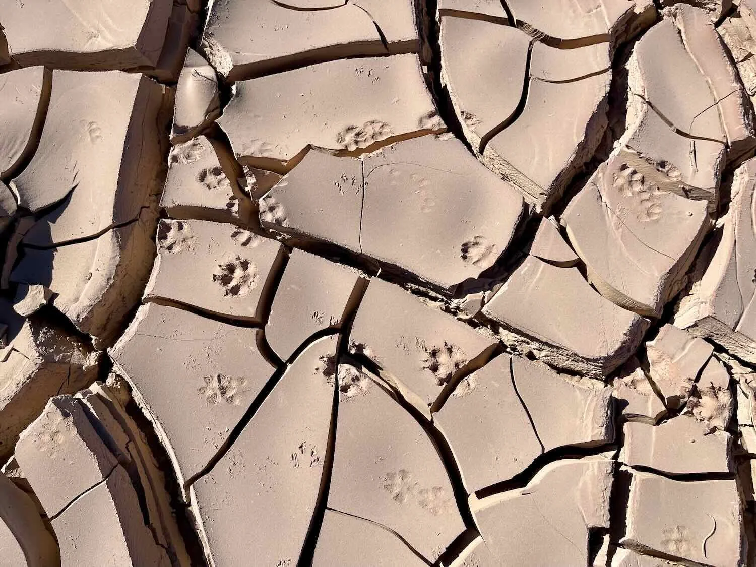
Judging from the myriad of animal tracks near our campsite the second night, there were quite a lot of animals in the area. We were lucky to spot one - a Smooth-throated Lizard, lurking among the twisted branches of a low, thorny bush. Many of the tracks were made by Lesser Rheas (a bird related to African Ostriches). Their footprints looked like dinosaur tracks. The big ones were even bigger than PedalingGal’s hand.
Smooth-throated Lizard. Route 40, N of Adán Quiroga, San Juan Province, Argentina. Copyright © 2019-2025 Pedals and Puffins.
Footprints of Lesser Rhea. Route 40, N of Adán Quiroga, San Juan Province, Argentina. Copyright © 2019-2025 Pedals and Puffins.
Unfortunately, it was very hard to avoid all the spines and spikes, some of which were more than an inch long. When accidents like this happened, we were glad we had tubeless tires with plenty of sealant to plug the holes. Route 40, N of Tucunco, San Juan Province, Argentina. Copyright © 2019-2025 Pedals and Puffins.
The third day out from San Juan dawned gray and cold. The region’s eternal sunshine had disappeared behind a thick layer of clouds that remained all day. A brisk side wind kept the chill factor high, so we maintained a quick pace all the way to the little village of San Roque.
We did make one food stop, however, when we reached the small hamlet of Niquivil (pop. 161). It was the first town we came to that had food, and we were ready to eat. The old man behind the run down counter in the tiny store, among the dusty jumble of canned goods and packs of cookies, assured us that the last two milanesa sandwiches in his cooler were freshly made the day before. We had our misgivings. But we were hungry, so we bought one to share (they’re really big) and devoured it while sitting on some cut logs set up as ‘chairs’ outside. Fortunately, we didn’t get sick. So the sandwich must have been fresh enough, after all.
The little, roadside shop where we stopped for a food break. Route 40, Niquivil, San Juan Province, Argentina. Copyright © 2019-2025 Pedals and Puffins.
We arrived in the very small village of San Roque (pop. <100) by mid-afternoon, ready for a break. The past few days of cycling had been fun, but more tiring than usual because of the fitness we had lost while recuperating from the flu in San Juan. Plus, we both still had a lingering cough, suggesting that we weren’t completely recovered, just yet. So even though San Roque didn’t have much going on, we decided to rest there a couple of days before continuing down the road. The break seemed appropriate given that we didn’t want to push ourselves too hard until we were more fully recovered from our illness, and had gained back some fitness. The very tranquil town was ideally suited to laying back and resting.
There aren’t a lot of lodging options in San Roque. We landed at a tiny hotel just steps from the main highway intersection. Despite the fact that it was the only hotel in town (all the other options were one-off cabins), La Posta was a fairly humble place. It had a total of only three rooms - and we were the only guests during our entire stay. The on-site restaurant was bigger, with around 10 tables. But again, we were the only patrons who ate at the restaurant during our stay. And the facade of the hotel facing the highway was decidedly low-key.
However, the experience of staying at the hotel was much better than those humble details imply. Our room was spacious and clean. Quique, the owner, was a one-man show running both the hotel and restaurant. He approached his role as host with humor and affection - going out of his way to make sure we were comfortable. He found it humorous that we liked to eat dinner at 5:30-6:30 pm versus the normal 8:30-9:30 pm when Argentines normally eat.
Over the course of two days we learned that he had moved to Argentina 10-15 years ago from Venezuela, after retiring from a job in the oil industry. He had been to the United States to visit a cousin who lives there, but told us he preferred the laid-back lifestyle in Argentina to the hectic pace of life in US cities. He certainly found a quiet corner of the world to settle in.
Although the front of La Posta hotel was very low-key, the patio outside the three guest rooms was lovingly decorated with rows of healthy, potted plants. Route 40, San Roque, San Juan Province, Argentina. Copyright © 2019-2025 Pedals and Puffins.
A cat at the hotel, who was always looking for attention. Route 40, San Roque, San Juan Province, Argentina. Copyright © 2019-2025 Pedals and Puffins.
The other cat at the hotel. This one was the boss. Route 40, San Roque, San Juan Province, Argentina. Copyright © 2019-2025 Pedals and Puffins.
This impressive mountain ridge formed the scenic backdrop for the village of San Roque. Apparently some of the cliff faces are very popular with rock climbers. San Roque, San Juan Province, Argentina. Copyright © 2019-2025 Pedals and Puffins.
The town had quite a few abandoned buildings on the outskirts. Route 40, San Roque, San Juan Province, Argentina. Copyright © 2019-2025 Pedals and Puffins.
Mud bricks sat next to a half-built structure. Route 40, San Roque, San Juan Province, Argentina. Copyright © 2019-2025 Pedals and Puffins.
As the only patrons of the hotel restaurant during our stay, we ate our meals in a side room, next to a roaring fire on a brick grill (probably so the owner wouldn’t have to heat the whole restaurant just for us). The fire took the edge off the cold but didn’t quite make the room warm, so we ended up eating most of our meals while still bundled up in our coats. Route 40, San Roque, San Juan Province, Argentina. Copyright © 2019-2025 Pedals and Puffins.
The Road to Silver Mountain (Guandacol)
The two-day ride from San Roque to Guandacol, the next big town on our route, took us through another wide open stretch of Argentina’s high plains. With so few communities around, the vehicle traffic was very light, which was wonderful.
By now we had fully transitioned to the less arid, high desert. There were lots and lots of scruffy bushes in the valleys that grew taller than a person’s head, and even some trees that grew about three stories high - giants compared to the short, thorny scrub of the lowland desert. Perhaps most surprising of all, many of the bushes still had their (tiny) leaves even though it was the dead of winter. That gave the landscape a muted, pale green veneer.
The morning light cast a golden glow on the mountains as we cycled out of San Roque. Route 40, E of San Roque, San Juan Province, Argentina. Copyright © 2019-2025 Pedals and Puffins.
We stopped for a break at a roadside shrine dedicated to the Virgin of Urkupiña, who was said to have appeared to a shepherdess on a hill in Bolivia. Many roadside shrines have simple benches where people can rest. But this one was quite luxurious, luring us in with a sturdy picnic table that looked like new, and even a tablecloth. Route 40, E of San Roque, San Juan Province, Argentina. Copyright © 2019-2025 Pedals and Puffins.
Someone created a roadside ‘art installation’ out of old tires with painted hubcaps. It was definitely eye-catching. Route 40, S of Hauco, San Juan Province, Argentina. Copyright © 2019-2025 Pedals and Puffins.
Layers of cliffs and rugged hills lined the edge of the gray-green valley. Route 40, S of Huaco, San Juan Province, Argentina. Copyright © 2019-2025 Pedals and Puffins.
Around noon we rolled into the village of Huaco (pop. 900), with hopes of securing a warm meal before camping out on the plains that night. Google Maps showed a restaurant along the highway in town, raising our expectations. When we arrived, the outside of the restaurant looked quite nice. It even had a garden with benches and some rustic pieces of art. But we were out of luck… the door was locked and the lights were out. No food for us.
A sign in the garden of the (closed) restaurant read “Huaco, Land of Poets.” The village’s most famous son was Buenaventura Luna, a musician, poet and politician who had a tremendous influence on Argentina’s folk music in the early 1900s. Route 40, Huaco, San Juan Province, Argentina. Copyright © 2019-2025 Pedals and Puffins.
We were hungry, though. So we backtracked half a mile to a tiny general store run by a husband-and-wife team. It was the kind of shop where you had to go to a window covered with bars, and ask for what you wanted while standing outside the building. You were not allowed to enter, but we were used to that. Usually in these stores the shelves of products are close enough to the window that you can see what they’ve got in stock, and decide what you want. Unfortunately, in this case, the shelves were at the back of a store room, too far away to see.
Shopping there became a guessing game. We would ask for something, they would go to the back and hold up what they had (which invariably was not what we had asked for) - too far away for us to see it. We had to keep asking questions to try to figure out what was on offer, and whether we wanted it or not. In the end all we bought was a can of tuna, a roll of cookies and a couple of drinks. It provided some calories, but it wasn’t particularly nutritious. We convinced ourselves it was better than nothing.
We grabbed some calories to fuel the final miles of cycling for the day at this little shop in the village of Huaco. We stood at the window for a long time trying to figure out what they might have in stock that we would want to buy. Route 40, Huaco, San Juan Province, Argentina. Copyright © 2019-2025 Pedals and Puffins.
The road after Huaco headed across the high plains in an almost perfectly straight line, no longer curving around the contours of the land. It was like cycling on a roller coaster with constant, small waves as we rode up and down across an endless series of dry drainage ditches. There must have been 15-20 spillways per mile. The slopes of each one were just steep enough to require shifting our gears back and forth from high to low. And the physical effect was like performing exercise intervals for two straight hours. Good thing we were fueled by that pack of cookies.
The rolling hills north of the village of Huaco took us back into wild, open desert. At one point we noticed a herd of animals crossing the road in the distance, ahead of us. They were far away, and we initially figured they were cows or goats. But as we got closer we realized they were guanacos. These were the first guanacos we had seen in months. It was a great feeling, like seeing old friends after a long interval. However, they were very shy. We managed to get just one photo before they took off into the bush.
A pair of guanacos eyed us warily from the safety of the tall thorn bushes. Moments later, they ran off into the desert. Route 40, N of Huaco, San Juan Province, Argentina. Copyright © 2019-2025 Pedals and Puffins.
We spent another blissfully quiet night camping out in the desert. The only sound that disturbed our sleep came right at first light. Suddenly we heard what sounded like a frightened donkey, braying. Our best guess was that a group of guanacos wandered by, and one let out an alarm call when it spotted our tent. But we don’t mind those kinds of noises. It was fun for us.
The night had been very cold. As we were breaking camp, PedalingGuy noticed that there was frost on his panniers - the first sign we had that the nights were now getting below freezing. Fortunately, none of our water bottles froze so it probably wasn’t below freezing for long.
Morning sun illuminated the hills behind our wild camp in the high desert. The morning air was quite brisk, and we even found some frost on our panniers. Route 40, N of Huaco, San Juan Province, Argentina. Copyright © 2019-2025 Pedals and Puffins.
During the final run into the village of Guandacol, nicknamed “The Silver Mountain,” we passed a few more mines and lots more dry arroyos. However, about three hours into our ride we had a big surprise. One of the spillways in the road was full of water! This was a first for us in this very dry region. Large flocks of burrowing parakeets filled the trees along the stream banks, clearly attracted to the oasis. The water flowing across the road was only about 3 inches (7.5 cm) deep, but it was quite wide. By the time we reached the far side, our feet were soaking wet - not an ideal situation with the chilly weather. At least we would be able to dry out in hotel room that evening.
A dirt road off the highway led to the Gualcamayo Mine, one of the gold mines in the area. You can just see the mining field among the mountains in the upper left. Route 40, N of Huaco, San Juan Province, Argentina. Copyright © 2019-2025 Pedals and Puffins.
After crossing what felt like hundreds of dry arroyos, we were surprised to reach one that had water flowing through. Luckily, it wasn’t very deep. Route 40, S of Santa Clara, La Rioja Province, Argentina. Copyright © 2019-2025 Pedals and Puffins.
Expansive vineyards surrounded the road as we cycled into town. Apparently the water in that small river we rode through was ‘sweet’ enough to support agriculture - unlike other rivers in the area that were salty. Route 40, Guandacol, La Rioja Province, Argentina. Copyright © 2019-2025 Pedals and Puffins.
We spent the next couple of days resting in the village of Guandacol (pop 1,300), since we were still building back our physical conditioning and we knew that we had some bigger mountains ahead of us.
We had arrived on June 21, the Southern Hemisphere winter solstice, which the town seemed to be celebrating throughout the weekend. There was a religious procession on Saturday. And when we walked over to the plaza on Sunday evening we were surprised to see a crowd of about 100 people standing outside the church, listening to a sermon that was being broadcast over a loud speaker. It looked as if the church just didn’t have enough room to let everyone inside for the big event. It was a festive time to visit.
The church on the village’s central plaza was decorated with purple and gold ribbons, possibly for the winter solstice. In parts of Argentina where European and indigenous cultures mix, the winter solstice is often celebrated with religious services. Guandacol, La Rioja Province, Argentina. Copyright © 2019-2025 Pedals and Puffins.
Feeling the Earth Shake
Much of Mexico, all of Central America, and Western South America is earthquake prone. As we traveled in the region during the last couple years, we experienced numerous earthquakes. Typically they were small, and we just briefly glanced at each other with a knowing look, then went back to sleep or got on with what we were doing. However, as we were getting ready for bed on the final evening in Guandacol, the whole building started to shake, violently.
This earthquake was different. The building was shaking with great force, and we immediately sensed that it was something to be concerned about. We were glad that the hotel we were in was just one story and we were on the ground floor, but we still decided to get dressed and leave the building. Fortunately, before we could get out the door, the shaking stopped.
It only lasted a few seconds, but it felt a lot longer and it was very disconcerting. Less than a minute later, the hotel manager was out in the courtyard between the rooms looking around, presumably to make sure everything was okay. No damage was done, probably because the earthquake was so short. Both of the big cities just to our south (Mendoza and San Juan) had been destroyed by major earthquakes in the last 150 years, so a Big One was certainly a possibility. Fortunately, this one wasn’t it, and the rest of the night passed quietly.
Cycling Through the Enchanted Valley
When we cycled out of Guandacol shortly after dawn, it was very cold. We bundled up in gloves, hats, and multiple layers of sweaters and jackets to stay warm. On the way out of town we got confirmation that the temperature was well blow freezing. Some irrigation hoses along the side of the road were spouting mists of water. And where the water landed on the vegetation, it froze in cascades of shimmering ice.
The morning was so cold that water escaping from a roadside irrigation hose froze in glittering columns that looked like blown glass. Route 40, Guandacol, La Rioja Province, Argentina. Copyright © 2019-2025 Pedals and Puffins.
We startled a large flock of Burrowing Parakeets at the edge of town. They squawked loudly as they took flight, expressing their annoyance at our passing. Route 40, E of Guandacol, La Rioja Province, Argentina. Copyright © 2019-2025 Pedals and Puffins.
The road between Guandacol and Villa Unión crossed a substantial ridge, climbing through a picturesque canyon called the Enchanted Little Valley. On our right, there were tall outcrops of beautiful, pink sandstone. While on our left the ridge was a mix of dark, basaltic lava with veins of rusty-red earth. We stopped often to enjoy the views and admire the colorful rocks.
A roadside sign welcomed us to the Vallecito Encantado (the Enchanted Little Valley). Dirt tracks and trails led back among the rock formations, but we just enjoyed viewing them from the main road. Route 40, E of Guandacol, La Rioja Province, Argentina. Copyright © 2019-2025 Pedals and Puffins.
One side of the valley was bordered by a ridge of dark, volcanic-looking rocks in multiple colors. Vallecito Encantado, Route 40, E of Guandacol, La Rioja Province, Argentina. Copyright © 2019-2025 Pedals and Puffins.
On the other side, a tall ridge of lovely, pink limestone towered over the highway. Vallecito Encantado, Route 40, E of Guandacol, La Rioja Province, Argentina. Copyright © 2019-2025 Pedals and Puffins.
This Pampas Fox spotted us at about the same time that we spotted him. He took our measure, before deciding to head back into the bush. Vallecito Encantado, Route 40, W of Villa Unión, La Rioja Province, Argentina. Copyright © 2019-2025 Pedals and Puffins.
Approaching Villa Unión we crossed another channel with water (this one was big enough to have a bridge). The Bermejo River is one of the few perennial rivers flowing through this region that never dries up because of a high groundwater table. There were even a few, small springs seeping out of the gravel berm next to the road. Route 40, W of Villa Unión, La Rioja Province, Argentina. Copyright © 2019-2025 Pedals and Puffins.
Towering Red Rocks on the Cuesta de Miranda
The next morning it was surprisingly warm when we rode out of Villa Unión (considering the freezing nights we had experienced, lately). Within 10 minutes we were onto the first ascent, and soon we were shedding layers in the bright sunshine. There was a stiff wind coming out of the north, and even the wind was warm. For the first time in many days, it was toasty enough to work up a sweat.
Right around 10:30am, we pulled over on the side of the road so PedalingGuy could take off his leggings because he was so hot. But to our surprise, the weather then changed, quite dramatically. In just the few minutes that we were stopped, the wind shifted 180 degrees and started blowing from the south - strong and cold. Suddenly we felt the need to start cycling again to stay warm.
It was a stunning change. Soon we were adding back layers of clothing. First our sweaters, then our wind jackets, and even our insulated vests. For the rest of the day, the temperature continued to drop, instead of increasing as it normally does in the afternoons.
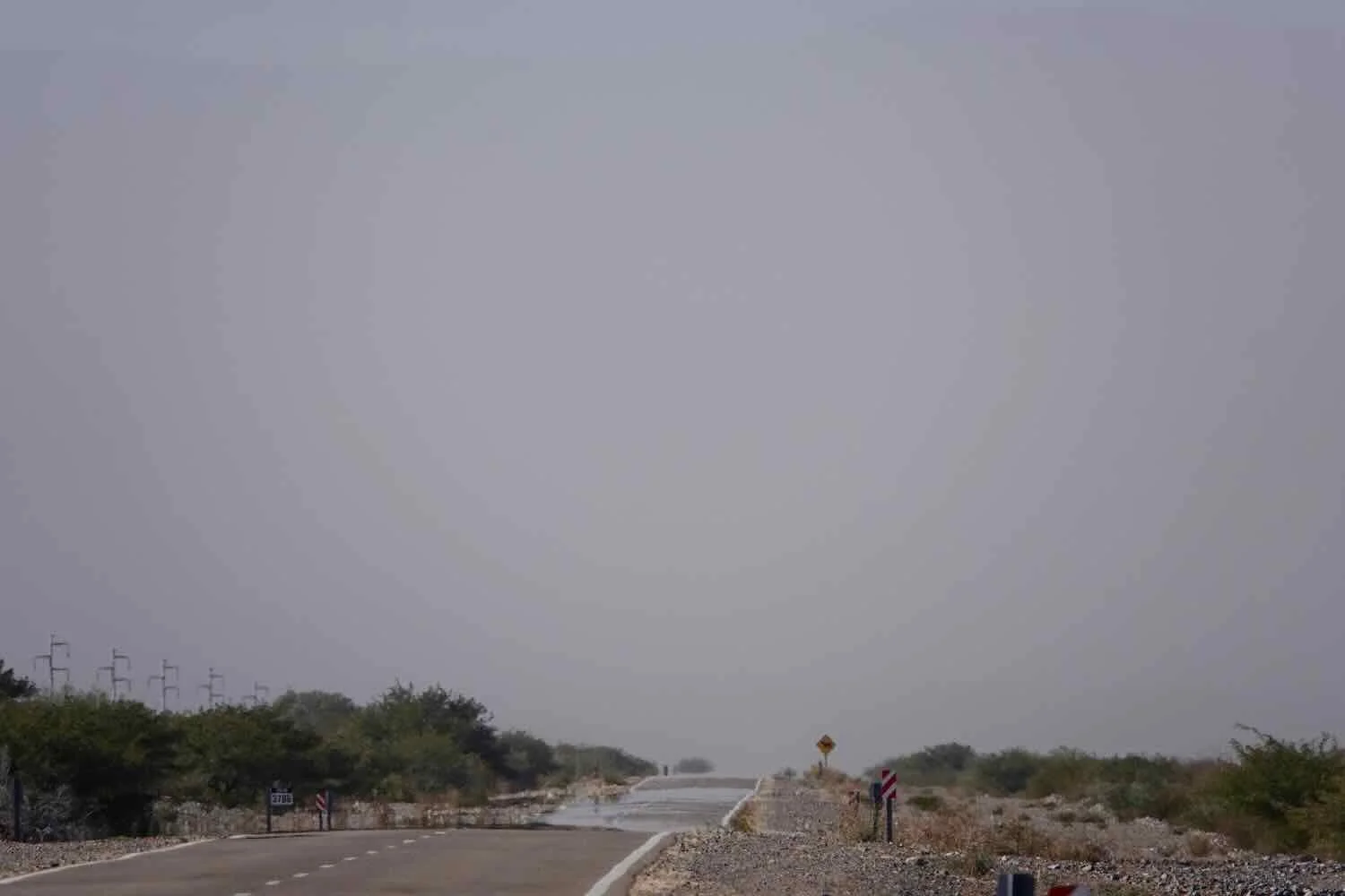
A half hour later, we emerged onto a broad, high plain. The stiff wind blowing across the flat desert filled the air with dust, creating a dull grayish-brown haze that obscured the lower slopes of the mountains around us. The higher ridge tops rose above the brown cloud, like silhouettes against the bluer sky above. But at ground level it looked particularly ominous, as if we were cycling into a big dust storm. Luckily the air immediately around us seemed fine. It was really just a trick of perspective over longer distances that made the air look so bleak. In the end, we did not get pelted with dust and sand, and the soft-focus scenery was an interesting change of pace.
On the high plain east of Villa Unión a southerly wind had filled the air with desert dust, obscuring our views of the surrounding mountains. Route 40, W of Puerto Alegre, La Rioja Province, Argentina. Copyright © 2019-2025 Pedals and Puffins.

At the far end of the plain we reached the start of the ascent over the Cuesta de Miranda, an ancient, pre-Colombian route through the mountains that is now a very popular scenic drive. Before long, the landscape became much more dramatic as the canyon walls closed in around us. Fanciful red rock formations tickled our imaginations, causing us to stop often and admire their artful shapes. An additional benefit was that the cliffs blocked most of the wind, so we could enjoy the beautiful views without all the dust in the air.
This albino horse was a resident of one of the small farms along the mountain route. Route 40, West Slope of Cuesta de Miranda, La Rioja Province, Argentina. Copyright © 2019-2025 Pedals and Puffins.
As we ascended towards the pass, red rock canyon walls closed in around us. Route 40, West Slope of Cuesta de Miranda, La Rioja Province, Argentina. Copyright © 2019-2025 Pedals and Puffins.
This rock formation reminded us of a duck, swimming to the left. Route 40, West Slope of Cuesta de Miranda, La Rioja Province, Argentina. Copyright © 2019-2025 Pedals and Puffins.
In moist depressions, dense bunches of grass bordered the road. Route 40, West Slope of Cuesta de Miranda, La Rioja Province, Argentina. Copyright © 2019-2025 Pedals and Puffins.
The rich, coral color of some of the rocky outcrops was stunning. Route 40, West Slope of Cuesta de Miranda, La Rioja Province, Argentina. Copyright © 2019-2025 Pedals and Puffins.
‘Forests’ of Argentine Saguaro cactus grew all over the mountain sides. Although they looked a lot like the famous saguaros that grow in the Sonoran Desert of North America, they are not even in the same genus. Argentine Saguaros are much more tolerant of cold (including freezing temperatures), grow much faster (up to a foot per year), and don’t get quite as tall as the Sonoran saguaros. Route 40, West Slope of Cuesta de Miranda, La Rioja Province, Argentina. Copyright © 2019-2025 Pedals and Puffins.
At 6,700 ft (2,040 m) in height, the Cuesta de Miranda was a fairly high pass, so we decided not to tackle it all in one day. We stopped at a humble, roadside hostal about a mile above sea level, in the village of Los Tambillos (pop. <50).
It was the only lodging for many miles, and it had clearly seen better days. Although there was a heating unit mounted on the wall, it did not work. Our room was freezing cold, warmed only by a mobile space heater no bigger than a loaf of bread, that was clearly not up to the task (partly because the very small room had a surprisingly high ceiling, where a lot of the heat seemed to disappear). The place was not particularly clean. And we decided not to risk bathing in the wet shower, which would have gotten water all over the bathroom. The best thing about the room was that the beds didn’t squeak.
There were no restaurants in the little village. So we were glad that the hostal had a mini grocery on site. There wasn’t much in stock, but with a bit of creativity we managed to put together a dinner. We tried not to think about how this dinner was not too different from what we might have eaten if we were camping: bread, tuna, canned peaches (which were delicious), drinks, and some cookies for dessert. It was probably about as nutritious as we could hope for.
The next morning we finished the climb to the top of the pass in the brisk, morning air. The gradient of the climb was steeper than it had been previously, but the scenery opened up a bit as we emerged near the top of the canyon. There also seemed to be even more water. We crossed several flowing streams, and at least one spring that came out of a cliff near the road.
All that water made for a fairly lush landscape, compared to what we were used to. Low shrubs covered with green leaves grew in dense clusters on the sides of the hills. The Argentine Saguaro cacti were abundant.
As we ascended towards the pass, the morning sun shone on the hills to our west, while we cycled in the cool shadow of the valley below. Route 40, West slope of Cuesta de Miranda, N of Tambillos, La Rioja Province, Argentina. Copyright © 2019-2025 Pedals and Puffins.
Every so often one of these Chilean Mesquite bushes would reach out into the road, to try to snag us with its dagger-like spines. Route 40, West Slope of Cuesta de Miranda, La Rioja Province, Argentina. Copyright © 2019-2025 Pedals and Puffins.
White, mineral deposits made the face of this red sandstone cliff look like it had been dusted with powdered sugar. Route 40, West Slope of Cuesta de Miranda, La Rioja Province, Argentina. Copyright © 2019-2025 Pedals and Puffins.
As we approached the top of the pass, the road climbed steeply toward the head of a box canyon. We wound back and forth on a series of switchbacks and hairpin turns that hugged the red cliffs. Route 40, West Slope of Cuesta de Miranda, La Rioja Province, Argentina. Copyright © 2019-2025 Pedals and Puffins.
At the head of the box canyon, we had a fantastic view back down the valley that we had just ridden through. Route 40, West Slope of Cuesta de Miranda, La Rioja Province, Argentina. Copyright © 2019-2025 Pedals and Puffins.
We made it to the top of the pass! The high point (‘punto alto’) was officially 2,040.5 m (6,695 ft). It was a great feeling - and we were ready for the descent on the other side. Route 40, Top of of Cuesta de Miranda, La Rioja Province, Argentina. Copyright © 2019-2025 Pedals and Puffins.
Rolling Downhill to Chilecito
We hadn’t cycled even five minutes from the top of the pass when we made our first stop. The Miranda Overlook was just too good to miss. Perched right at the bend of the tightest, steepest hairpin turn on a very steep and winding road, the overlook served up one of the best views we’d had in a long time. From the edge of the small parking area the land fell rapidly away, plunging several hundred feet into the Miranda River Valley. The olive-green valley was corralled by rugged, red sandstone buttes, with the distant lowlands hidden in a dusty haze between iron gray ridges. It took our breath away.
The impressive view from the Miranda Overlook. Route 40, East Slope of Cuesta de Miranda, La Rioja Province, Argentina. Copyright © 2019-2025 Pedals and Puffins.
As we were admiring the view, a group of folks were intrigued by our bicycles and came over to chat with us. They were two couples traveling together, from Chilecito and Mendoza. The guy from Mendoza warmly welcomed us to Argentina, and made sure to tell us that we really must enjoy an asado (Argentinian cook-out) while in the country. With a twinkle in his eyes, he talked at length about how asados are such an integral part of family life and tradition, of course accompanied by wine from Mendoza. It was heart warming how eager he was to share some cultural insights with us about his country. We didn’t have the heart to tell him we already had enjoyed an asado restaurant meal, way back when we had first arrived in Buenos Aires.
A group of friendly folks from Chilecito and Mendoza befriended us at the Miranda Overlook, entertaining us with tales of their love for the Argentinian tradition of asado (Sunday barbecues, steeped in gaucho tradition). Route 40, East Slope of Cuesta de Miranda, La Rioja Province, Argentina. Copyright © 2019-2025 Pedals and Puffins.
From the overlook we flew down the hairpin turns on the mountain. Vehicle traffic continued to be very light, which gave us plenty of room to maneuver around the numerous turns. The only tricky part was that, in a few areas, there was a lot of rock debris along the side of the road that had slid off of the adjoining cliffs. We even passed a crew of guys shoveling up the rocks and clearing the road margin. We couldn’t know for sure, but we suspected that the rocks had come tumbling down as a result of that earthquake we had felt in the village of Guandacol. The epicenter of the quake had been pretty close to these mountains.
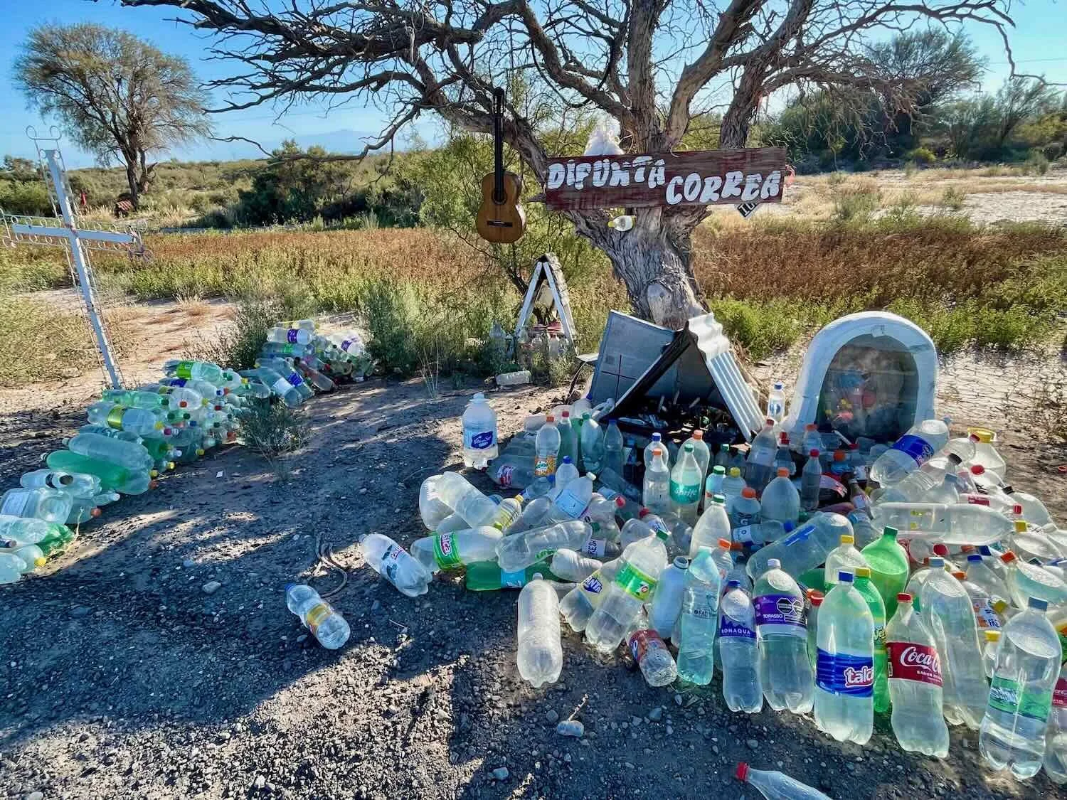
We stopped at one other pull-off along the descent. It was another shrine to the Difunta Correa. Like the others we had seen near San Juan, this shrine also was overflowing with bottles of water offered to the folk saint as sign of respect and devotion. Route 40, East Slope of Cuesta de Miranda, La Rioja Province, Argentina. Copyright © 2019-2025 Pedals and Puffins.
We spent our second night on the mountain in a little hotel in the village of Miranda (pop. 250). Although we still had a bit of trouble heating the room, it was a huge step up from our previous lodging in Los Tambillos - particularly since it was clean and had a nice, hot shower.
From there, our final ride into Chilecito was a short one. So we pampered ourselves by taking a long breakfast break at a cafe in the village of Nonogasta, which lies right at the bottom of the hill. We savored a combination of burgers, eggs and fries, all of which was fresh and well made. We could feel the nourishment flowing into our bodies, giving us energy for the rest of the ride.
Down in the valley, we found ourselves back in wine country - with symbols of wine culture everywhere. This old barrel was on display at a major highway intersection. Route 40, Nanogasta, La Rioja Province, Argentina. Copyright © 2019-2025 Pedals and Puffins.
As we left the cafe and turned north, we had a wonderful surprise. From Nanogasta to Chilecito we were able to cycle on a nice, new bike path that was fully separated from the highway. The path itself was very smooth and wide - better than many road surfaces we had to contend with in rural areas.
The freedom from having to worry about traffic was particularly welcome when we saw some cool wildlife along the way. Our first encounter was with a Spot-winged Falconet - a little bird of prey that is the only species in its genus (more closely related to caracaras than to other falcons). A quirky behavior of the falconet is that it often nests in the large, woven nests of other birds like monk parakeets, and sometimes even cohabitates in those communal nests with the parakeets. It makes you wonder what the parakeets think about that.
Not long after spotting the falconet, we caught a quick glimpse of a very large rodent with long legs and pointy ears. It was a Patagonian Mara - a species that we had seen previously at a zoo-like park in Buenos Aires. That made our day. We didn’t get a photo because it was extremely shy and ran away quickly. But its jackrabbit-like body was unmistakable. This was a species that we had been hoping to encounter in Argentina, but we were already nearing the far northern limit of its range in the wild. It was fantastic to finally see one.
We spotted this handsome Spot-winged Falconet along the bike path between Nanogasta and Chilecito. Route 40, N of Nanogasta, La Rioja Province, Argentina. Copyright © 2019-2025 Pedals and Puffins.
This photo is of a Patagonian Mara that we saw at the Buenos Aires Ecopark. We saw another one of these endearing rodents along the bike path between Nanogasta and Chilecito, but it was very shy and ran away before we got a photo. Ecoparque (formerly the zoo), Buenos Aires, Argentina. Copyright © 2019-2025 Pedals and Puffins.
View of the Sierra Famatina mountain range, famous for its gold, silver and copper mines. Route 40, S of Chilecito, La Rioja Province, Argentina. Copyright © 2019-2025 Pedals and Puffins.
Rolling into the town of Chilecito, Route 40, La Rioja Province, Argentina. Copyright © 2019-2025 Pedals and Puffins.
Staying Warm in Little Chile (Chilecito)
The day after we arrived in Chilecito, the biggest cold snap of the winter blew through northern Argentina, sending nighttime temperatures down into the 20sF (-5C to -6C). With more camping just ahead of us on our route, we decided that the sensible thing to do was to stay a few extra days in Chilecito and wait for the antarctic weather to pass. Even with two wall-mounted heaters and another electric space heater going full blast, our rental apartment barely stayed warm enough (we still had to bundle up in several layers of clothing).
At least we had relatively warm refuge to return to after venturing out around town. Here are some photos from our layover in Chilecito:
In three different parts of town we saw this mural about the sign language alphabet. We wondered if there was a school for hearing-impaired people in town. Chilecito, La Rioja Province, Argentina. Copyright © 2019-2025 Pedals and Puffins.
This was the first town where we saw ornamental orange trees growing in parks and along roads. In spite of the frigid weather, we took this as a sign that we were finally getting far enough north to enter a milder climate. Chilecito, La Rioja Province, Argentina. Copyright © 2019-2025 Pedals and Puffins.
This mural depicted some of the town’s better known sights, including Route 40, an iron support for the historic, mining cable car, and the Christ of the Pass statue. We would end up visiting all three of these attractions. Chilecito, La Rioja Province, Argentina. Copyright © 2019-2025 Pedals and Puffins.
While Chilecito’s modern economy is primarily based in agriculture (wine, olives, walnuts and fruit trees), for a time it was the center of the most important mining area in Argentina. The surrounding gold, silver and copper mines were so profitable that Chilecito was the first place in the country outside of Buenos Aires to have a branch of the Argentina National Bank. During the mining heyday, large numbers of experienced miners from Chile moved there looking for work, earning the city its current name - Chilecito.
One mine just west of the city was so prolific that in the early 1900s they built a cable car system to rapidly carry the raw ore from the mountains to the city - replacing the much less efficient mule trains. At the time, it was the longest (35 km) and highest (rising to over 15,100 ft of elevation) cable car installation in the world. Operating like a very long ski lift with 650 miniature gondolas, the cable cars transported buckets of raw ore directly to Chilecito’s freight railroad. They also carried supplies and miners back up to the mining camps.
The cable car system stopped running in 1927 when the ore concentrations became too low to be profitable using the mining technology available at the time. However, the German company that built the cable car system had ‘guaranteed’ its operation for 100 years. Remarkably, 120 years after its construction, much of the infrastructure still stands and has become one of Chilecito’s most unique tourist attractions.
One freezing cold morning, we walked over to the museum at Cable Car Station 1 - the end of the line where the ore was transferred from the cable cars to freight trains. The imposing, iron structure was definitely impressive. We also enjoyed checking out the historical artifacts and photos inside the museum.


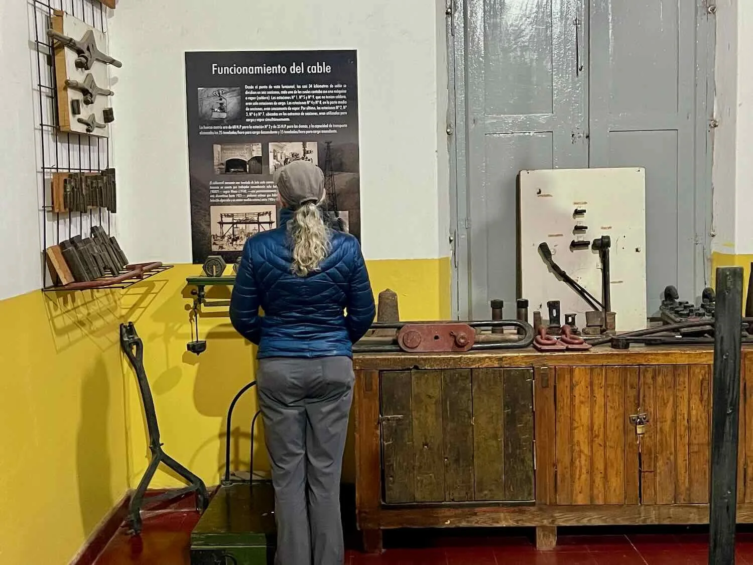
There are nine stations along the full, 21.5 mile (35 km) length of the cable car system. Intrigued by what we saw at Station 1 in town, we decided to ride our bicycles up the mountain to visit Cable Car Station 2. It was a big climb, rising 1,500 ft (460 m) in just seven miles, to the top of a nearby mountain ridge. From the deck of the station we had an expansive view back towards Chilecito. We also went inside the station to check out the massive steam engine that was used to launch the cable cars up the next, even steeper, set of mountains.
View towards Chilecito from the deck at Cable Car Station 2. Santa Florentina, La Rioja Province, Argentina. Copyright © 2019-2025 Pedals and Puffins.
The temperature on the mountain ridge was still below freezing when we arrived on our bicycles. Bushes on the nearby mountainside were covered with white frost. Cable Car Station 2, Santa Florentina, La Rioja Province, Argentina. Copyright © 2019-2025 Pedals and Puffins.
A key function of the nine stations along the length of the cable car system was to provide the power that lifted the gondolas up into the mountains. We were able to get an up-close look at the big steam engine in Cable Car Station 2. Santa Florentina, La Rioja Province, Argentina. Copyright © 2019-2025 Pedals and Puffins.
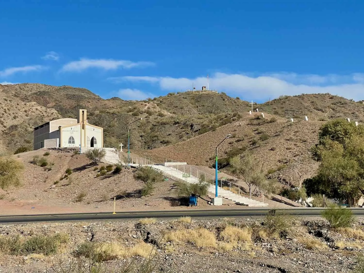
On our final morning in Chilecito, we walked over to visit the pristine, white statue, Christ of the Pass. It stood on a hill overlooking the town at the top of 200 stairs. Chilecito, La Rioja Province, Argentina. Copyright © 2019-2025 Pedals and Puffins.