Pacific Coast Route, Part 1: Cycling from Sedro-Woolley, Washington to Astoria, Oregon

15 - 26 October 2022
15 October - Sedro-Woolley to Fort Ebey, Washington (46.2 mi, 74.4 km)
16 October - Fort Ebey to Four Corners, Washington (49.5 mi, 49.5 km)
17 October - Four Corners to Belfair, Washington (34.7 mi, 55.8 km)
18 October - Belfair to Elma, Washington (51.4 mi, 82.7 km)
19 October - Elma to Toledo, Washington (64.0 mi, 103.0 km)
20 October - Toledo to Cathlamet, Washington (53.5 mi, 86.1 km)
21 October - Cathlamet, Washington to Astoria, Oregon (32.9 mi, 53.0 km)
A Different World
Everything was different once we descended out of the Cascade Mountains. For the vast majority of the past four months we had cycled through remote areas. We were surrounded by rugged mountains with infrequent, small towns and large expanses of sparsely-populated wilderness. Encountering a store along the way was often an occasion to celebrate, since anywhere from two days to a week could pass without any way to resupply. Not anymore.
We had entered the Puget Lowlands, that fertile and highly-developed zone in western Washington where roughly two thirds of the state’s population resides. Fortunately, our route would avoid going through the biggest metropolitan areas, like Seattle. Instead we would cycle on secondary roads and highways, through semi-rural areas devoted to pastures, hayfields, waterfront towns, and working forests. It took some time to adjust to the much greater volume of vehicle traffic. But there was no denying that it was luxurious to have access to multiple stores and restaurants each day. We lightened our loads considerably by reducing the amount of food and water we carried on our bikes, now that we could rely on frequent resupply options.
On our way out of the town of Sedro-Woolley, we marveled at how high gas prices had risen recently. The price of a gallon of gas was up 30% from earlier in the spring - when we already thought it was sky-high. Looking at the current prices, we were very glad to be traveling by bicycle.
Gas prices have gone through the roof over the past couple of years. Looking at these prices, we were glad to be traveling by bicycle. Sedro-Woolley, Washington, USA. Copyright © 2019-2022 Pedals and Puffins.
After a couple of hours cycling across relatively flat farmland, we finally reached the shores of Puget Sound. We hadn’t seen the coast since our departure from Deadhorse, Alaska back in June. And it had only been a day or two since we had come down out of the mountains. Seeing the big expanse of water so close at hand affected us in a way we didn’t expect. The profound beauty of the rugged coastline seemed fresh and new. And we both felt a deep sense of satisfaction from having completed the “northern mountains” leg of our journey. It was thrilling, and we looked forward to our rendezvous with the Pacific Ocean.
We finally turned southward once again. For the next 1,750 miles (2,800 km) we would follow the Pacific Coast Route, perhaps the most popular long-distance cycling trail in the United States. Dozens of cyclists make the journey (or sections of it), each year, mostly in the summer. To support this flood of 2-wheeled travelers, the state parks in Washington, Oregon and California often provide high-quality, hiker/biker campsites for a reduced fee. However, most cyclists are gone by mid-October as the cold and damp rainy season starts to take hold. As a result, we encountered only a handful of other cyclists along the way. Most of the time we would find ourselves alone in the hiker/biker sites, enjoying the tranquility of off-season travel.
Our first really good view of Puget Sound came when the route ascended onto a very high bridge over a wide channel of water. We stopped at the height of the bridge to admire the cluster of denim-blue islands out in the bay. But what really caught our attention was a very unusual bridge at the mouth of the channel. Known as the BNSF Swing Bridge, it operates on the same principle as a drawbridge in that it can remain open to let boats pass by, and be closed to allow trains to cross over. But instead of lifting the bridge up and out of the way, the swing bridge rotates its middle section sideways to open the channel for boats. The bridge is still in use, and several trains pass over it each day. Unfortunately, we didn’t get to see the bridge swing into action.
Our first view of Puget Sound, from the top of a high bridge. The BNSF Swing Bridge - a rotating railroad bridge - rests open in the channel below. Swinomish Channel, Washington, USA. Copyright © 2019-2022 Pedals and Puffins.
As our route followed the shoreline we passed a cluster of warehouses along the waterfront. Buoys stored inside stacks of crab pots provided a dash of color. Anacortes, Washington, USA. Copyright © 2019-2022 Pedals and Puffins.
A few minutes after crossing the bridge we stopped for a break, and realized that we were resting next to a giant tangle of wild blackberries. Even better, the plants were laden with juicy, ripe berries. We both had flashbacks to the summer of 2018, when we had enjoyed wild blackberries in large quantities while cycling across Idaho and Oregon on the TransAmerica Bike Route. These berries seemed to be ripening very late in the season by comparison. Of course, we grabbed a ziplock bag and filled it with berries to take with us (while nibbling a few as a quick snack).
Not far down the road, we stopped at the first little store we could find. We bought a pint of chocolate-chip cookie dough ice cream, and settled down for a heavenly treat. The berries were very ripe, sweet and flavorful, and they complemented the ice cream perfectly. It was beyond awesome.


Immediately after we finished our ice cream break, the route launched uphill. We ascended onto the first of a seemingly infinite number of rocky ridgelines that define the rugged coastline in the Pacific Northwest. Stretches of flat road would become rare and precious interludes among the constant ups and downs created by the fierce geologic pressures along the Pacific Ring of Fire. We marveled at the beauty of sheer seaside cliffs, wind-sculpted shorelines, and impressively tall trees. Each breath as we pedaled along was filled with fresh, cool air scented with a hint of pine and cedar.
Deception Pass is renowned for its scenic beauty, as well as the historic bridge which crosses the inlet hundreds of feet above the dangerously swirling water below. Deception Pass, Washington, USA. Copyright © 2019-2022 Pedals and Puffins.
Darth Vader’s helmet makes an unusual lawn ornament. Oak Harbor, Washington, USA. Copyright © 2019-2022 Pedals and Puffins.
We spent our first night along the Pacific Coast Route in the hiker/biker camping area at Fort Ebey State Park. We were especially grateful for the designated hiker/biker camping in this park, because we had heard that most of the regular camping sites (for people who arrive by car or RV) are reserved a year in advance. There were three delineated campsites for cyclists, and each one had a tent pad that was basically a raised sandbox. A wooden frame was filled with sand that lifted the tent off of the ground, and presumably provided drainage in case of rain. But the tent pads were designed for tents much smaller than the Taj Mahal (aka, our Hyperlite Ultamid 4 Pyramid tent). The pad at our campsite was barely big enough to hold our tent floor, and we had to place the stakes in the ground outside of the tent pad. Fortunately, the dense coastal forest protected our site from the wind, and we didn’t have any trouble with the stability of our tent pitch.
The sandy pad at our campsite was barely big enough to hold our tent. Luckily, we were able to make it work. Fort Ebey State Park, Washington, USA. Copyright © 2019-2022 Pedals and Puffins.
Strange Things, and Noises In the Night
It was a Saturday night, and there were lots of people at the park. Even though Halloween was still a couple of weeks away, you could tell that the holiday was coming. There were kids dressed up as miniature versions of Spider Man or as princesses. But we were a bit surprised to see a group of about eight high school or college age girls come by dressed as witches (long, black dresses, pointy black hats). They were carrying candles, and had some other witchy paraphernalia with them. For about an hour after darkness settled in they huddled in the woods along a nearby trail, and didn’t seem to realize that they were so close to the hiker/biker camping area. There was a guy with them who was taking photos or a video. We suspected that it was all intended for a posting on social media.
After setting up the tent we went for a walk along the sandy bluffs overlooking a wide inlet, with the Olympic Peninsula on the far side. We explored an old, WWII gun battery that was part of the original fort. As we watched the deep-orange sunset, a giant cruise ship drifted by.
A wind-swept tree on a coastal bluff. Fort Ebey State Park, Washington, USA. Copyright © 2019-2022 Pedals and Puffins.
Sunset over the Olympic Peninsula, across Puget Sound from our campsite. The Olympic Mountains are hidden in a smokey haze. Fort Ebey State Park, Washington, USA. Copyright © 2019-2022 Pedals and Puffins.
Back at camp we visited for a while with another couple who had arrived on bicycles. They had lit a fire and invited us to join them. We learned that they were at the park to celebrate their anniversary. When we mentioned that we hoped to cycle all the way to Patagonia, the husband (who was in the Navy) told us about the thrill he had felt when sailing around the tip of South America, through the Strait of Magellan. The wife was a very avid cyclist, and shared stories about competing in the Leadville 100 bike race last year. She was able to finish the race within the cutoff time without having had the opportunity to train at a high altitude. We were pretty impressed. It was fun talking with them, and sharing the warmth of their fire.
As we headed to bed, a barred owl hooted in the woods for a while. Then, as we were settling in for the night, another sound added to the spooky atmosphere of that forest. The quiet night was shattered by four, almost-human-like screams. We wondered whether there were still some young people messing around. But the calls were a bit too regular to have been made by a person. In the morning, the other couple asked us if we had heard the screams, and if we knew what they were. They seemed as stumped as we were. Later, after some research, we think it was likely a bobcat. But we had never heard anything that sounded quite like that before.
Ferrying Among the Islands
From Fort Ebey State Park, we cycled along a lovely, water-side road that looked out over a tranquil bay. But we couldn’t stop too long to soak up the views. We had only 45 minutes to get to a ferry between the islands in Puget Sound, or we would have to wait another 1.5 hours for the next boat. We decided to forego breakfast in the quaint town of Coupeville, and make a bee-line for the ferry.
Penn Cove, a tranquil haven for sailboats, along the road to Coupeville, Washington, USA. Copyright © 2019-2022 Pedals and Puffins.
Even though we had pushed our cycling pace, we arrived at the dock only 15 minutes before the scheduled departure of the ferry. That was nerve-racking, because the ferry website is clear that cyclists are supposed to arrive a half hour before departure. But we were in luck. They seemed to be running a bit behind schedule, and the ferry was still unloading vehicles from its last crossing. So we weren’t late, after all. We boarded the boat without any issues.
Boarding the Port Townsend-Coupeville Ferry. The boat carries vehicles on the lowest deck, with two passenger decks above. Coupeville, Washington, USA. Copyright © 2019-2022 Pedals and Puffins.
We stowed our bikes on the lower level with the cars and motorcycles. There wasn’t a way to lash the bikes to the boat, so we just leaned our bikes against the wall. Fortunately, that wasn’t a problem because the ferry ride was very smooth, even during departure and docking. Port Townsend-Coupeville Ferry, Washington, USA. Copyright © 2019-2022 Pedals and Puffins.
The passenger areas of the ferry were not crowded at all. We were able to secure prime sightseeing spots along the railing at the front of the boat. From there we kept busy watching the myriad of wildlife (sea gulls, guillemots, auklets, and sea lions) as the big vessel gently skimmed across Admiralty Inlet.
A group of sea lions seen from the Port Townsend-Coupeville Ferry. Washington, USA. Copyright © 2019-2022 Pedals and Puffins.
Approaching the picturesque village of Port Townsend via ferry. Washington, USA. Copyright © 2019-2022 Pedals and Puffins.
The best part of our ride in the afternoon was a short stint on the Olympic Discovery Trail. The trail starts in Port Townsend, and runs across the northern coast of the Olympic Peninsula. But because we had decided to maintain our southward trajectory on the Pacific Coast Route, we only rode on the Olympic Discovery Trail for the first seven miles.
The trail departs Port Townsend near a boat repair facility. We marveled at the massive size of the dry-docked fishing boats that lined the boatyard, in various stages of repair. After barely two miles of cycling along the waterfront the trail turned inland, traversing a series of wooded hills. The surface was hard-packed ash, making for easy riding (except for the hills). It was a delightful way to get away from the busy streets for a while.


Cycling through coastal conifer forests along the Olympic Discovery Trail. Port Townsend, Washington, USA. Copyright © 2019-2022 Pedals and Puffins.
We arrived at Kitsap Memorial State Park around 4:30pm. Still not used to the fact that the tourist season was over, we hustled into the park because we were worried that our late arrival might preclude us from securing one of the three hiker/biker campsites. But there was no need to hurry. In the end, we were the only cyclists who showed up that night.
Similar to the previous night at Fort Ebey, our campsite was nestled within a forest of impressively tall, straight Douglas fir trees. It would be hard to guess how tall the trees were, but coastal firs can reach heights of 120 ft (36.5 m). They lose their lower branches as they grow, and there is relatively little undergrowth in the shadow of the big trees. As a result, we had the feeling that we were camping within a great hall filled with stately columns.
Looking up into the canopy of trees surrounding the hiker/biker sites at Kitsap Memorial State Park. They grow tall and straight around here. Four Corners, Washington, USA. Copyright © 2019-2022 Pedals and Puffins.
As the sun was setting, we took a walk out to the shores of Hood Canal. The colors were particularly vivid, due to a bit of lingering forest fire smoke in the air. But this evening we could see the outline of the Olympic Mountains much better as the sun dipped behind the distant ridge. In the fading light, a fishing boat cut silently across the water.
Ochre sunset over the Olympic Mountains. Kitsap Memorial State Park, Washington, USA. Copyright © 2019-2022 Pedals and Puffins.
After dark a chorus of coyotes kept us awake for a little while. We’ve been consistently surprised by the number of coyotes, especially in close proximity to more populated areas. Kitsap Memorial State Park is actually a pretty small natural area, surrounded by pockets of suburban homes. Even so, there seemed to be quite a few coyotes in the vicinity of the state park, in several different packs. Of course, the yapping of the coyotes got the local dogs going. And they kept up the barking for quite a while after the coyotes stopped. The dogs can’t seem to help but get all riled up when they hear the coyotes.
Later in the night, when things had finally quieted down, a Northern Spotted Owl hooted in the woods.
An Unexpected Detour
The next morning, right out of the gate, we headed up a big, steep hill which was immediately followed by another bigger, steeper hill. We were feeling great about nearing the top of the second climb, which would put us on top of a ridge with some more mellow riding.
But then we were passed by a police vehicle with its lights on. Moments later, a man standing by the side of the road asked us if we knew why the power was out. He said he had heard “a loud bang,” and then lost power in his house. He had come out to the road to see if a nearby transformer had exploded. But at this point, nothing unusual could be seen. The mystery deepened.
Before long we were passed by a fire truck and an EMS vehicle with their lights on and sirens blaring. This was starting to look serious.
Finally, as we approached the very top of the hill, we saw the collection of emergency vehicles blocking the road up ahead. When we arrived, we learned that someone had run their car off the road and knocked over an electric utility pole. The car was in the roadside ditch, and live power lines were down. It was a pretty bad situation. The road was completely blocked in both directions.
Unfortunately for us, it would be a long detour to go around. So we decided to wait for the utility crew to arrive, and hopefully clear the live wires off the road. They showed up about 20 minutes later. That’s when we noticed that one of the lines that had come down appeared to be a high-tension wire, which could be really dangerous. We could also hear a chainsaw up ahead, but we couldn’t see exactly what was happening.
Utility and emergency crews assessing the situation at the scene of a car accident that blocked our path. We were told that a car went off the road and into the ditch, taking out an electric utility pole in the process. South of Four Corners, Washington, USA. Copyright © 2019-2022 Pedals and Puffins.
It was another 10 minutes before we finally got the bad news. An officer came over to tell us that it was going to take at least a couple more hours to create a safe lane of passage. The fallen high-tension wire had to be handled by a specialized crew, which was not yet on the scene. That was really a drag. But the officer was very nice, and he gave us excellent directions for a suggested detour. It turned out to be a pretty good alternative road that only added about 2.5 miles (4 km) to our ride. So we didn’t suffer as much as we had anticipated.
Later, after an authentic Mexican lunch at a tiny taqueria, we started to worry about how much time we had lost at the scene of the accident. We decided to stay on the main road (Hwy 3) for the rest of the day, rather than going back onto the Pacific Coast Route (which paralleled the main road on hillier terrain). The price we paid was that for the rest of the day we cycled along a VERY busy road with fast-moving traffic. Also, the road’s shoulder varied from nice and wide to very narrow. And even when it was wide it was littered with debris. A couple of times we literally found ourselves cycling through clusters of nails or piles of broken glass in the road margin. It was a miracle that neither one of us ended up with a flat tire. If there were any punctures, the sealant in our tubeless tires did its work and we did not have to stop and make any repairs
We were happy to finally arrive at our lodging at the end of a long day. As a nice touch, the motel was decorated with appealing coastal scenes painted on weathered wood. We finished off the evening with a couple of over-sized burgers that were almost too big to handle.

With Halloween just over a week away, the stores are overflowing with pumpkins. This year, they seem to come in more sizes, shapes and colors than ever. Belfair, Washington, USA. Copyright © 2019-2022 Pedals and Puffins.
Another Day of Delays
We were up before dawn and it looked like we were going to get a good, early start for a big-mileage day. But just after breakfast we suffered the first of three major delays for the day.
Before heading out on the road, we had a crisis of confidence regarding our plan to cycle all the way to Astoria, Oregon, in four days. The weather forecast said there could be as much as two inches (5 cm) of rain on the fourth day. Some rain is okay when cycling, but long, intense downpours in cold weather make cycling both stressful and uncomfortable. We decided to make a hotel reservation in Astoria so that we would know we had a place to hunker down and dry off if the rain turned out to be a problem.
But there didn’t seem to be any good hotel options in Astoria. So we asked ourselves whether it would be better to stay somewhere else? That set off a cascading set of tangents as we researched hotel options in other towns along the way. But those alternatives weren’t any better. After a lot of back-and-forth we finally decided to go ahead and make a reservation at a less-than-ideal hotel in Astoria. We hoped it was the right decision, because we were now committed to an aggressive riding schedule for the next four days, in order to make our hotel reservation in Astoria. We usually try to avoid rigid schedules because having the flexibility to adjust our mileage can greatly improve each days ride.
With that delay behind us, we finally got our bikes out on the road just after 9am - quite a bit later than we should have.
But we had cycled less than a mile when we hit our second delay. Suddenly, PedalingGuy’s back tire started spewing sealant out of a serious puncture. It was as if the cycling gods heard us rejoicing yesterday about not getting a puncture on the horrible road debris, and decided to remind us that you can never take that for granted.
We pulled over on the side of the busy highway to work on the tire. We tried to get it to seal by just rolling the tire in some sand beside the road. But the sealant didn’t gel. When we got out our tire repair tool, there weren’t any plugs in the applicator (we had failed to restock it). So we had to fiddle with that. Finally we were able to insert a Dynaplug into the tire, and that seemed to fix the leak. But by then the tire had lost a ton of air. So we had to use our hand-pump to get it back up to pressure. It was definitely one of our longer puncture delays of the trip.
At the top of a ridge, the road leveled out and we cycled along very smooth, new pavement with a wide shoulder. For a little over an hour we stayed on this road. It felt wonderful to finally be making good time. But then we hit our third delay.
In the middle of the forest we came upon a construction zone with single-lane traffic. Although the work zone was only about a mile long, we ended up waiting for nearly a half hour while they halted traffic in both directions to make way for some heavy equipment. It felt like it took forever. When we were finally able to go, we were very glad that they let us ride through on our bikes instead of having to load them into the pilot car. But a steep uphill in the construction zone shredded our muscles as we strained to keep up with the cars. Cycling was just a bit harder after that.
Toward the end of the day there was one final, big climb. We stopped about halfway up the hill and each drank an energy drink that had some caffeine. That set PedalingGuy on fire. He really pushed the pace hard for the rest of the way into the town of Elma, Washington. We were assisted by a general downhill trend, but PedalingGuy didn’t let up on the effort. We pedaled like crazy whether the gradient was up or down.
Amazingly, we arrived in Elma around 3:30pm, even after covering 50+ miles (80+ km) and with all the delays. We literally flew over the final 20 miles.
The folks who run the Elma RV Park were incredibly sweet. They really made us feel welcome, heaping freshly-made chocolate chip cookies on us (four cookies each, for a total of eight), and insisting that we should let them know if there was anything we needed. We appreciated the TLC after a long day. This RV park ended up being an especially nice place to spend a night. It was a short walk to restaurants, had a beautiful, level, grassy area for the tent under a shade tree, and was quiet at night. We would highly recommend it to other cyclists.
Our little tent spot in the RV park. Elma, Washington, USA. Copyright © 2019-2022 Pedals and Puffins.
We both slept soundly, even though several trains rolled right by the campground during the night, blowing their whistles. (It felt like we were back in Canada.) That was a testament to how tired we were, plus how much we’ve gotten used to the noise of traffic and trains.
Coastal Fog
The next morning arrived in a dense fog. It didn’t matter that we had pitched our tent under a tree. Everything exposed to the air was soaked. We couldn’t delay to let the tent dry, because we had a long day planned. So we packed up the soggy tent and hit the road.
Cycling through the fog. South of Elma, Washington, USA. Copyright © 2019-2022 Pedals and Puffins.
The fog lasted nearly until noon. And even after that there was a haze in the air that shrouded anything in the distance.
An old barn in a misty field. Cedarville, Washington, USA. Copyright © 2019-2022 Pedals and Puffins.
A red-tailed hawk survey’s its domain from the top of a hay roll. Oakville, Washington, USA. Copyright © 2019-2022 Pedals and Puffins.
The first 40 miles (64 km) of riding were relatively easy, with very low and gentle hills. We covered most of that before having lunch in the bustling town of Centralia. When we reached Centralia, we were blown away by the amount of cars on the road. On the way into town, there was a huge traffic jam that went on for several miles. We easily passed the long line of many vehicles on our bicycles. But then we had to contend with the traffic in town. It was a bit hair-raising. We rode for long stretches on the sidewalks. It made us appreciate the fact that most of the day’s ride was on quieter back roads.
We ended the day in Toledo, Washington, a town that seems to enjoy painting its buildings with scenes from the past and present.
This painting on a water tank depicts a scene from the town’s early days, with a lumber train taking logs to the mill. Toledo, Washington, USA. Copyright © 2019-2022 Pedals and Puffins.
A more modern image on a wall near the Fresh Market. Toledo, Washington, USA. Copyright © 2019-2022 Pedals and Puffins.
The Road to the Columbia River
The next morning was foggy, but we were thrilled that it was not nearly as damp as the day before. Our tent, pitched under a tree, was actually dry. The bikes were dry, too.
A smoky/foggy sunrise. Toledo, Washington, USA. Copyright © 2019-2022 Pedals and Puffins.
We rode through a mix of suburban farms with horses, cows and goats in small yards, interspersed with urban commercial areas. Most of it wasn’t too scenic.
The town with the most charm was Castle Rock, Washington. They had a sign at the entrance to town that listed a bunch of awards they had won for town beautification efforts. A number of the awards recognized Castle Rock’s emphasis on decorating the town with live flowers. It struck us as a particularly competitive form of civic pride. But the town’s well tended public spaces were genuinely pleasing places to be. The path we followed was lined with information signs about the pioneering families that settled the area, and the industries (like logging) that built the town.


Display of a cut, 100-year old Douglas fir in Lion’s Pride Park. Castle Rock, Washington, USA. Copyright © 2019-2022 Pedals and Puffins.
We’ve started seeing lots of the tassel-topped pampas grass along the route. It’s very pretty, but it’s considered an invasive weed in the state. Kelso, Washington, USA. Copyright © 2019-2022 Pedals and Puffins.
After cycling on sidewalks through the very urban areas of Kelso and Longview, we headed west on the Ocean Beach Highway (Hwy 4), toward the coast. It was very stressful. For 20 miles (32 km) we cycled on a narrow or non-existent shoulder with a steady stream of fast-moving traffic. Everybody seemed to be in a hurry, and unwilling to wait for a safe opportunity to pass. Lots of cars passed us while there was oncoming traffic, and there was barely enough room for all of us. Way too many cars got too close for comfort. To make matters worse, we were often laboring up hills in lower gears, trying to maintain a straight line, with cars wizzing past.
We were both worn out when we arrived in the town of Cathlamet, Washington. We made our way to the marina where we planned to camp, only to find that the office had closed at 3pm - an hour and a half before we arrived. We weren’t sure what to do, but figured we could pay in the morning if necessary. So we headed over to an area that looked like it might be for tent campers.
As we were checking out the campsites, a guy rode up on an electric bike and claimed to be the camp host. He told us we could camp in any of the campsites along the water, as long as we paid him $25. We didn’t have any proof that he was the host, but he seemed to know what he was talking about so we gave him the money and pitched our tent. Rain was in the forecast, and it appeared to be raining across the Columbia River in Oregon. We crossed our fingers that it wouldn’t be a soggy night.


After the challenging ride, we didn’t have the energy to go into town for dinner. We simply snacked on food we already had. It felt like the right decision. We needed a chance to relax and unwind.
Arrival in Oregon
Unfortunately, rain showers started around 5am, and fell steadily until about 7:30 in the morning. We ended up having to pack up a wet tent, again. Wet tents are not only soggy, but they weigh a lot more than dry ones, which slow down the bikes (never a good thing). On the bright side, we were able to wait for the rain to stop before packing our things, and we got out on the road under cloudy, but dry skies.
Concern about the rain starting up again, and the pressure to catch the ferry across the Columbia River to Oregon, pushed us to cycle as quickly as possible. As a result, we were unable to enjoy a breakfast in Cathlamet. That was unfortunate, because it looked like a cool little town. Perhaps we’ll have a chance to visit again someday.
Waiting for the ferry across the Columbia River. Puget Island, Washington, USA. Copyright © 2019-2022 Pedals and Puffins.
The crossing of the Columbia River from Washington to Oregon took only 12 minutes on the open ferry boat. There was lots of space. Only five cars were on board with us, and we had the only bikes.
Loading bikes on the ferry to Oregon. Columbia River, Washington, USA. Copyright © 2019-2022 Pedals and Puffins.
The guy who managed the loading and unloading of the boat was very friendly, and came over to visit with us during the crossing. We passed a large dredging barge in the main channel, and he told us how the dredging process worked. They only have to take the dredged mud a short distance down the river, where it is dumped in “deep holes” in the riverbed. Apparently these sections of the channel are scoured out by currents, and the dredge material washes out to sea from there.
There was a small boat moored along side the dredging barge. The ferry guy told us how earlier that morning the little boat had capsized, and had been rescued by a tugboat that works with the barge. The boat was now right-side up and it didn’t look too much worse for wear. From a distance, you wouldn’t guess that it had been capsized. We also learned from the ferry guy that boats are regularly rescued on this part of the river, and that they often see stuff like small boats and jet-skis floating by.
On the far side of the river, our route climbed out of the valley. At the top of the ridge, we stopped at an overlook recommended by the ferry guy. From there we had a great, although slightly misty, view of the Columbia River and Puget Island below. It was interesting to see that the low-lying island was mostly covered with farm fields - very different from the forest-shrouded mountains that surrounded the river.
Puget Island, Washington, as seen from the viewpoint at the top of the big hill. Oregon, USA. Copyright © 2019-2022 Pedals and Puffins.
We were happy to discover that the road shoulder was generally more rideable here than it had been on the last stretch of highway in Washington. That was especially helpful because by mid-morning it had started to rain. It was a light, but steady, rain that soaked both us and the road. We took a break at a convenience store just after 11am, where we enjoyed cups of hot chocolate and some cookies. Our bikes stayed dry under an awning outside, while we warmed up and dried off inside. It was a heavenly break. We felt especially lucky since there was only one table and two chairs in the whole store, which fortunately were unoccupied when we arrived.
A whimsical sign at the Logger Restaurant, next door to the convenience store in Knappa, Oregon, USA. Copyright © 2019-2022 Pedals and Puffins.
Memories at the Mouth of the Columbia River
Arriving in Astoria, it was fun to see the town’s waterfront, again. Four years ago we ended our first cross-country bike tour in Astoria when we completed the TransAmerica Bike Route. Now, we enjoyed hearing the familiar sound of sea lions barking near the docks. And we couldn’t help stopping to pose for a few photos in some of the spots we had visited before.
Our arrival in Astoria. We’re posing in front of a Pilot Boat on display at the maritime museum. The Pilot Boats guide giant ships up and down the treacherous waters of the Columbia River. Astoria, Washington, USA. Copyright © 2019-2022 Pedals and Puffins.


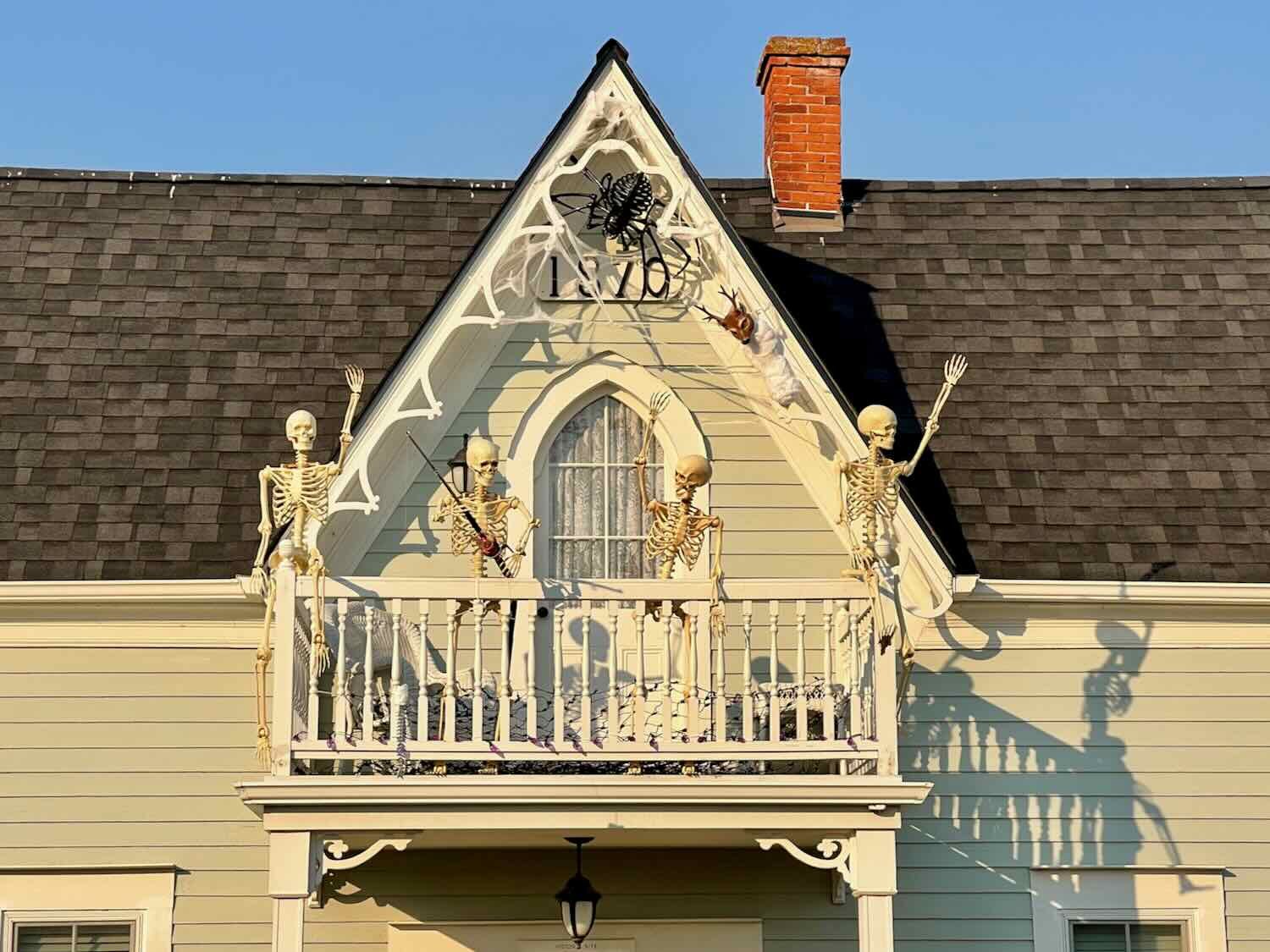
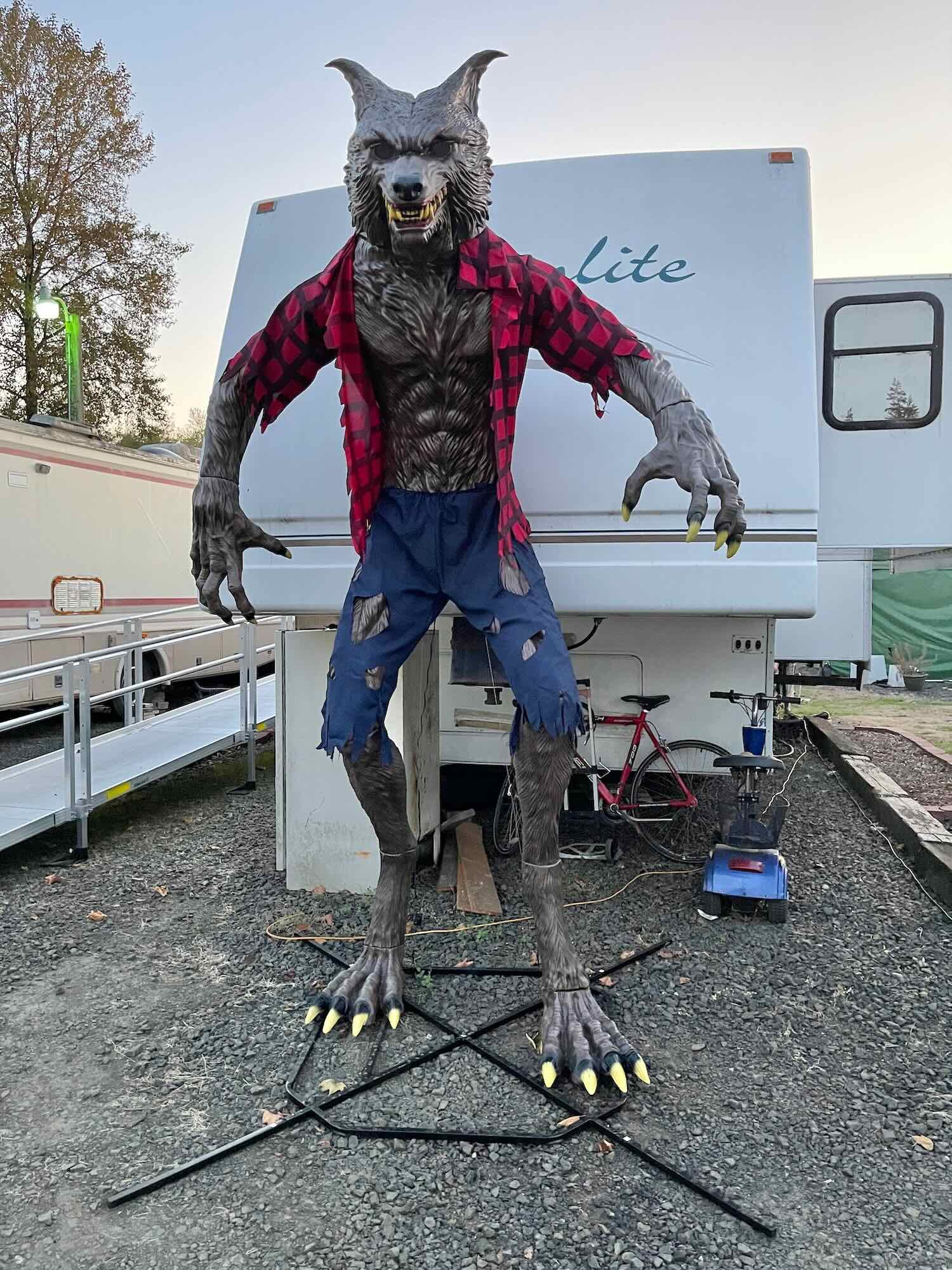
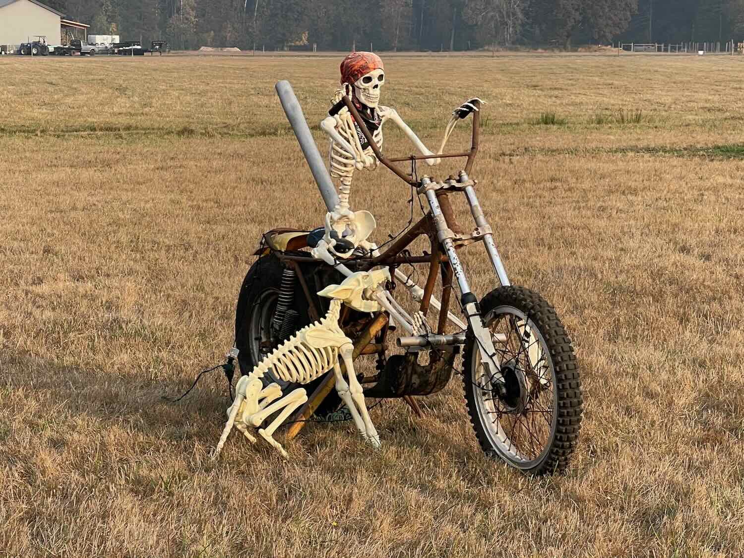
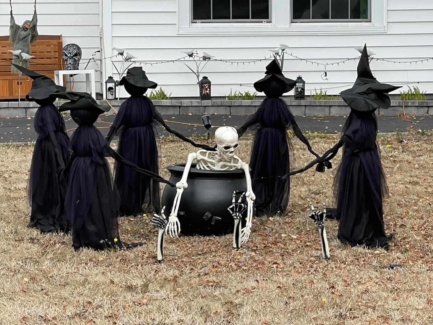
Spirits of Halloween
On this leg of our trip, Halloween was fast approaching. People in the US have always enjoyed celebrating the holiday, but some folks really go all out with their decorations. This year, skeletons seemed to be in fashion. To wrap up this post, we’ve gathered photos of a few of the more creative displays we saw along the way.