Cycling Across the Border to the Yukon Territory: Oh, Canada!

17 - 28 July 2022
17 July - Border City, Alaska to Beaver Creek, Yukon (24.5 mi, 39.4 km)
18 July - Beaver Creek to Discovery Yukon Campground (33.5 mi, 53.9 km)
19 July - Discovery Yukon to Wild Camp on Alaska Highway (48.6 mi, 78.2 km)
20 July - Wild Camp to Congdon Creek Campground (47.4 mi, 76.3 km)
21 July - Congdon Creek Campground to Wild Camp on Alaska Highway (45.6 mi, 73.4 km)
22 July - Wild Camp to Haines Junction, Yukon (10.0 mi, 16.1 km)
23 July - Haines Junction to Wild Camp on Alaska Highway (78.8 mi, 126.8 km)
24 July - Wild Camp to Whitehorse, Yukon (18.6 mi, 29.9 km)
25-28 July - Layover in Whitehorse, Yukon
We entered Canada via the ALCAN/Beaver Creek border crossing, which is open 24 hrs, 7 days a week. Unlike most border crossings, there’s a surprisingly big gap between the US and Canadian immigration border posts. After passing the US check point (where we did not have to stop since they only want to talk to people traveling North into Alaska), we cycled nearly 20 miles (30+ km) before reaching the Canadian border post. In between, there is a pretty elaborate rest stop marking the international border, and celebrating the friendly relationship between the two countries. We took a break there to commemorate another milestone in our journey south.
We made it to Canada! Entering the Yukon Territory. Alaska Highway, US-Canada border. Copyright © 2019-2022 Pedals and Puffins.
One foot in each country. Alaska Highway, US-Canada border. Copyright © 2019-2022 Pedals and Puffins.
Not So Fast…
After crossing into Canada, we had expected excellent road conditions. We recalled that another cyclist, who we had met on our way into Tok, told us that the roads in Canada were really good for bicycles. It was a rude awakening when we discovered this was not the case - at least not on the Alaska Highway.
The Canadian section of the border zone is almost all under some phase of construction. Pretty quickly we encountered long patches of loose gravel. Then we arrived at a section where they were actively laying new chip-and-seal pavement, and once again we had to ride in a pilot car. After that we cycled through another 15 miles of highway that was in various stages of disrepair. We spent much more time riding on squishy, dusty gravel than pavement, and this slowed us down a lot.
This sign says it all. The road within the “no man’s land” between the US and Canadian border posts was a dusty, gravel-covered mess. Alaska Highway, US-Canada border. Copyright © 2019-2022 Pedals and Puffins.
We were fortunate that the rainstorms that had dogged us since our departure from Fairbanks had passed. Otherwise the ride would have been more difficult. Every so often, we would stop where the road rose high above a lowland bog or lake, and soak up the view with the rugged mountains in the background.
The beauty of the northern boreal forests continues to impress us. Alaska Highway, US-Canada border. Copyright © 2019-2022 Pedals and Puffins.
Our official arrival in Canada went smoothly. The border agent had a dry sense of humor, and chided us for “jumping the line” by going around a very long line of waiting cars and trucks. But it took only a minute or two for her to review our documents, and we were waved into Canada. It was really very simple, and we were happy about that.
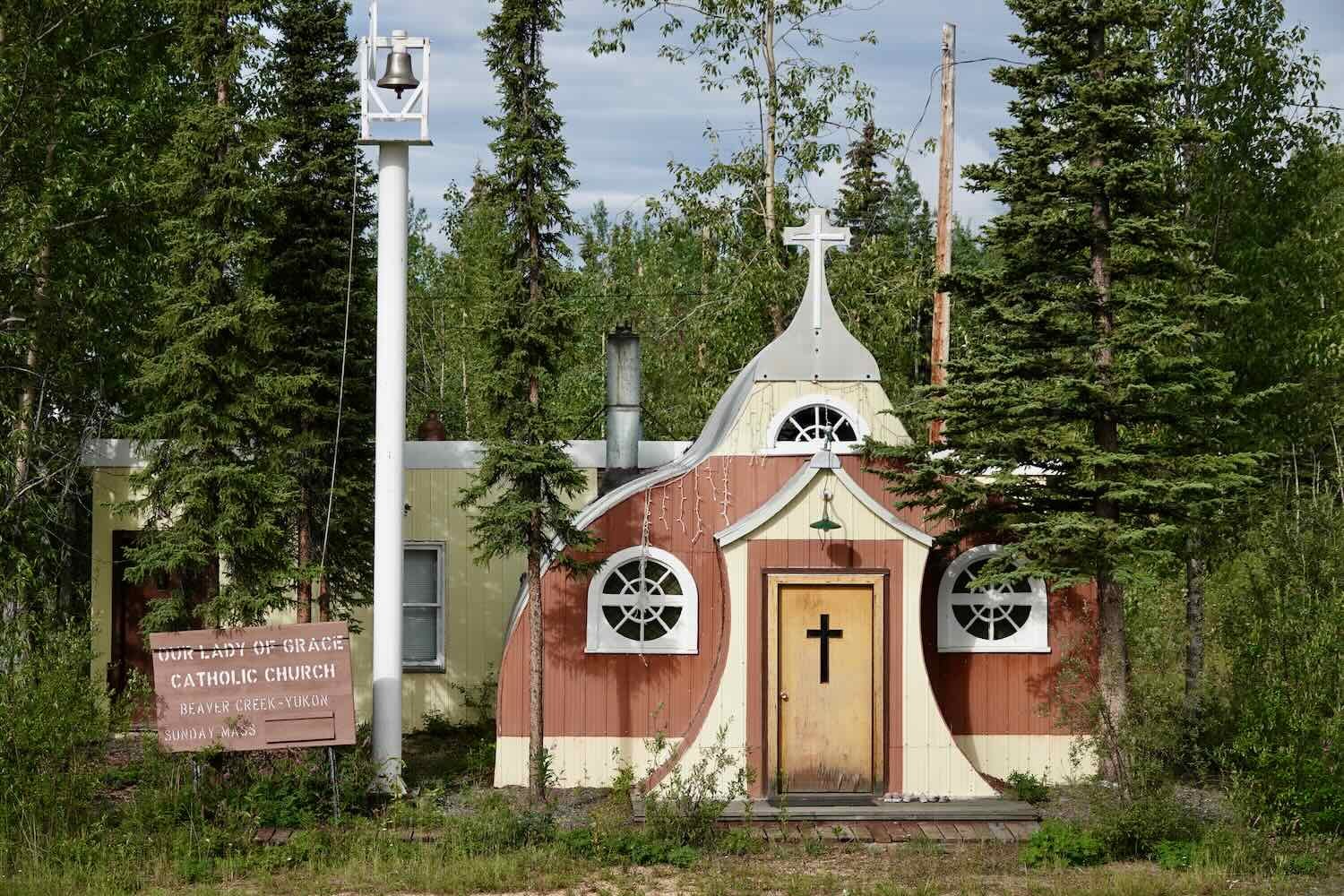
In Beaver Creek, the Canadian border town, we had to make a decision. It was already mid-afternoon (partly because we had lost an hour when crossing into Canada, a different time zone). We figured we could make it to our next planned stop by 8pm. But rain was forecast to resume in the evening. After considering our options, we decided to stay in Beaver Creek and have a meal at the local restaurant called Buckshot Betty’s. There, Buckshot Betty herself runs the nice little cafe a little like the Soup Nazi on the famous Seinfeld Episode.

The Bear We Missed
We departed Beaver Creek the next morning under patchy clouds with light winds, cool temperatures, and beautifully clear air. It was a perfect morning for cycling. Since we didn’t have a long day planned, we stopped often to admire the scenery. We passed through an area where the forest appeared to have burned recently, and were dazzled by the purple carpet of fireweed flowers that covered the hillsides.
A vivid, magenta carpet of fireweed covered hills that appeared to have burned in a recent forest fire. Alaska Highway, Yukon Territory, Canada. Copyright © 2019-2022 Pedals and Puffins.
It’s astonishing how quickly fireweed can spread to cover large areas after a fire. A single plant can produce up to 80,000 seeds per year that sail through the air on fuzzy parasails (much like milkweed or dandelion seeds). They float easily into open, burned landscapes. And they flourish in the sun-drenched, nutrient-poor, ashy soils left after a fire or other calamity. A year after the eruption of Mt. St. Helens in the US, more than 80% of the new seedlings in areas that had been covered with volcanic ash were fireweeds. Now, that’s a rugged plant.
Early in the day’s ride, a driver in a vehicle heading in the opposite direction slowed down when he approached us. Leaning out his window, he yelled that there was, “a big bear by the side of the road” ahead. At this point, we hadn’t seen a bear yet in Canada, but we knew that this was grizzly bear habitat. So for the next several miles we were on high alert. But the bear must have moved away from the road by the time we passed by. We didn’t see any bears that day, big or small.
Unfortunately, the wonderful weather didn’t last all day. Before noon the weather became unsettled, and dark clouds gathered ominously to the west. About an hour later, the inevitable happened. The rain was light at first, but before long it was pouring down, and we were soaked to the bone. Then, we were pelted with some hail. Cold and wet, we focused on getting to our destination. We passed a couple of groups of people with butterfly nets, apparently collecting insects along the side of the road, but we didn’t think much about it at the time.
Arriving at the Discovery Yukon campground, we found out that all of the cabins and most of the tent sites were occupied by some “researchers.” They were not at the campground when we checked-in, but they would be back in the afternoon after completing their field work. That gave us some time to pitch our tent, get a warm shower, and rest a bit before the group returned.
Before long we were clean, warm and dry. The sun came out (mostly), and it stopped raining (eventually). Walking around the grounds, we got a kick out of the various collections of vintage machines and tools scattered around the property. There were old outboard motors, chain saws, washing machines, logging tools, and assorted other stuff arranged neatly in clusters.


Then out of the blue, PedalingGal recognized someone walking down a path. It was an old colleague whom she had worked with back in the 1990s. What a small world. He was there with the group of researchers conducting a “bioblitz” - an intensive, 7-day effort to record as many different species as possible within a specified area. It turned out that another old colleague from the Yukon was also there. We had fun chatting with them about the bioblitz, telling them about our bike ride, and reflecting on the amazing coincidence of our paths crossing again after all these years.
A Cold Wind Blows
As we cycled deeper into the Yukon, we steadily gained elevation until we left the lowland taiga forest of Alaska behind. By the time we departed from the Discovery Yukon campground, we were traveling through the Shakwak Valley - a broad depression along an ancient fault line that defines the border between two, high-elevation ecoregions. On our left was the Watson Highlands boreal forest, with its rugged, hard-rock hills, spruce-covered plateaus, and deeply-cut valleys.
Boreal forest under blue skies. Alaska Highway, Yukon Territory, Canada. Copyright © 2019-2022 Pedals and Puffins.
On our right was the St. Elias Range tundra. The snow-capped peaks of this ecoregion had crept closer to the Alaska Highway with each mile we pedaled. Internationally recognized for its extensive glaciers, the St. Elias Range forms a vast wilderness of rock and ice, hosting large populations of North America’s most iconic megafauna. Grizzly bears, wolverines, wolves, Dall sheep, mountain goats, caribou, and trumpeter swans are all relatively abundant here.
Exquisitely beautiful trumpeter swans use the Shakwak Valley as a migration corridor. We saw numerous pairs of swans along this part of our route. Alaska Highway, Yukon Territory, Canada. Copyright © 2019-2022 Pedals and Puffins.
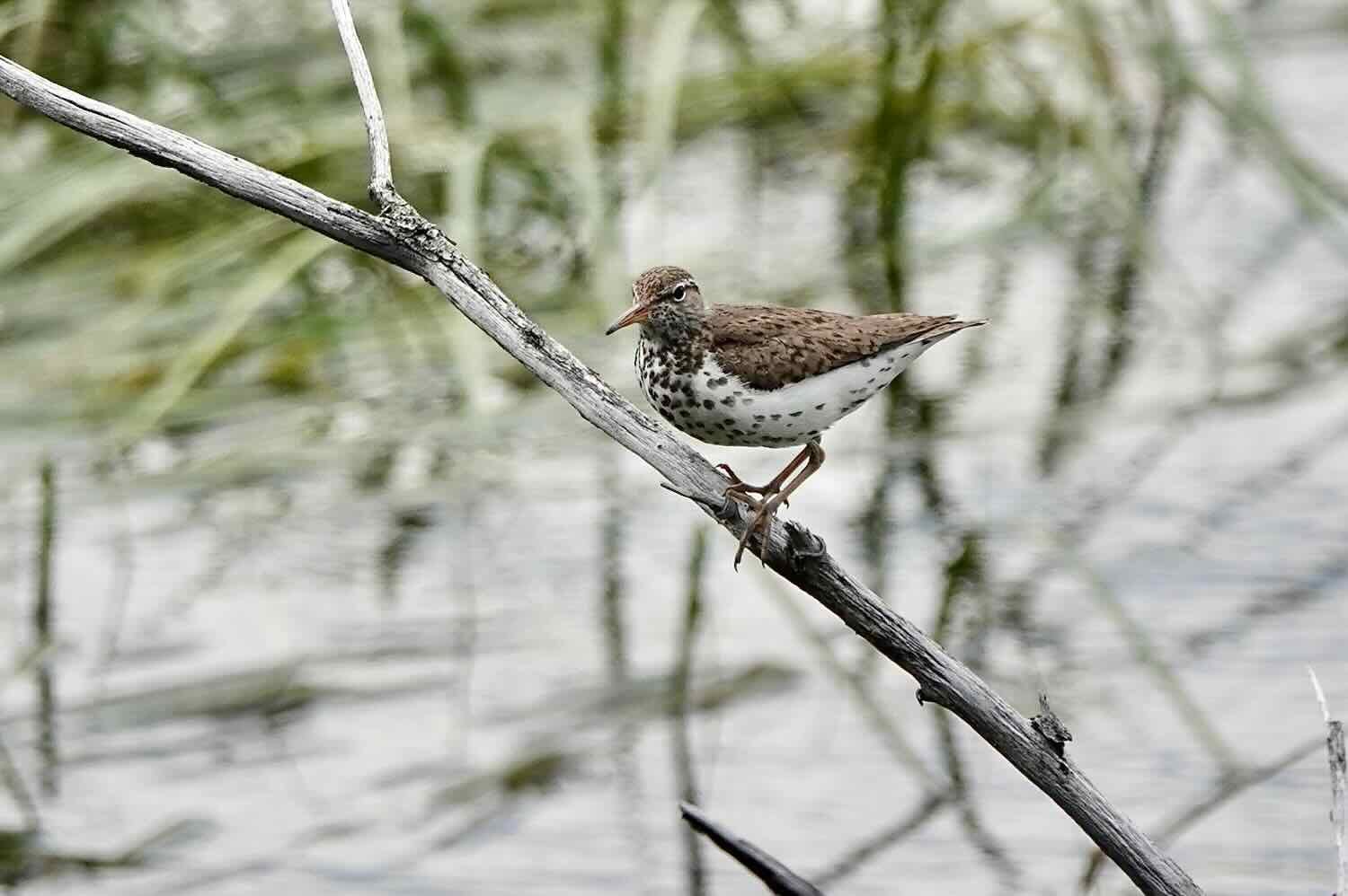
Not all of the beauty in this region is big, though. We stopped often to enjoy the brightly-colored, roadside flowers and smaller residents like spotted sandpipers throughout the day.

But nothing drew our attention quite as much as the soaring peaks of the St. Elias Mountains. Clear skies provided gorgeous views of the summits, which still glistened under a blanket of snow in mid-July. As we cycled through the valley, we couldn’t help stopping frequently to admire and photograph the mountains that seemed to become even more beautiful as the day progressed.
Ice and snow on the St. Elias Mountains provided a breathtaking backdrop for our cycling. Alaska Highway, Yukon Territory, Canada. Copyright © 2019-2022 Pedals and Puffins.
There was one, less fortunate aspect to cycling so close to all that snow. “Katabatic winds” are generated when the air over mountain ice fields cools and becomes more dense. Then gravity pulls the cold, heavy air downhill, like water gushing down a mountainside. In a place like the Shakwak Valley, the descending air is ultimately channeled into a narrow trench, increasing its velocity even further. On warm summer days, the winds can reach hurricane forces.
The katabatic winds that rush down from the St. Elias Mountains are well known to locals, and they always blow downhill from the southeast to the northwest. That means any cyclist heading southward on the Alaska Highway through this region will have to battle headwinds for several days - a fact we hadn’t fully appreciated before experiencing the phenomenon ourselves.
We can’t say for sure how fast the headwinds were blowing, but they were consistently strong. Some of the gusts felt like they might have approached 40 mph (65 kph). What’s more, the wind was cold, causing us to stay bundled up even in the bright July sun.
During the early part of the day we had seen two different grizzly bears. So we became extra cautious when it came to camp. In addition to eating our dinner several miles before locating a campsite, we carefully checked the area for bear sign before deciding to settle down for the night. We found a cozy spot in a small, abandoned gravel pit that was surrounded by trees to block the wind.
As evening approached, wispy ice clouds gathered, giving the sky an ominously exotic look. Alaska Highway, Yukon Territory, Canada. Copyright © 2019-2022 Pedals and Puffins.
A Very Long Day
The next day, nothing went according to plan.
We awoke to another steady rain, thwarting our hopes of getting an early start. We huddled in our sleeping bags, fully expecting the rain to stop at any time. But it just kept coming. It’s times like this that having a big tent like the Taj Mahal really pays off. We relaxed, chatted and snoozed off-and-on in the comfort of our dry tent until the rain finally abated around 3:30pm.
By that point we had resigned ourselves to spending the rest of the day in our cozy gravel pit, and resuming our cycling the next day. Our first priority was eating, because we couldn’t even have a snack inside the tent in bear country. All or food was tied up in a tree 100m away.
After a pleasant brunch out by the main road, we considered our options. The sky had cleared. It was shaping up to be a beautiful afternoon, and we were both eager to get moving after lounging around for most of the day. So we went straight back to camp, packed up our gear, and started our ride for the day shortly before 5pm, one of our latest starts ever. Lucky for us, we knew that we were still far enough north that it would not get fully dark until late at night which would give us some time to cover a meaningful number of miles.
Less than 10 minutes into our ride, we crossed paths with Galen from the UK, cycling solo. He had started in Calgary, Alberta, and was headed north as far as he could go with the time he had available. He asked us about the conditions for cycling to Coldfoot, Alaska, because he hoped to make it that far before turning around and catching a flight home from Fairbanks.
About an hour later, we stopped at a rest area that overlooks the Kluane River, a major waterway in the region. It’s ecologically important for its rich salmon runs, as well as serving as a migration corridor for the Yukon’s smallest woodland caribou herd. The salmon from the Kluane River support a large numbers of grizzly bears - one of the most dense populations of grizzlies in the territory. In fact, the portion of the Alaska Highway along the Kluane River is considered to be a top spot in the territory for viewing grizzly bears.
A quick rest break overlooking the Kluane River. Alaska Highway, Yukon Territory, Canada. Copyright © 2019-2022 Pedals and Puffins.
It was right after our departure from this rest area that we had our second close encounter with a grizzly bear, as it gorged on berries in a narrow strip of forest between the highway and the rest area.
It was late in the evening when we finally reached the tiny town of Burwash Landing, on the shores of Lake Kluane. We had hoped to secure a hotel room in the next town, so we used the cell signal in Burwash Landing to call them for a reservation. It was bad news when we learned that they were already fully booked. Nearly all the rooms had been reserved for “contractors” working on all the road construction. This was the first time we encountered this problem, but it would not be the last. Apparently these far northern roads require endless maintenance. As a result, it’s common in warmer months for the road workers to completely take over any local accommodations, which can be sparse to begin with. It meant another night of camping in grizzly country for us.
As evening light illuminated the mountains and clouds, we cycled through grizzly bear country, wondering where we might spend the night. Alaska Highway, Yukon Territory, Canada. Copyright © 2019-2022 Pedals and Puffins.
We hustled the next 10 miles (16 km) to Destruction Bay anyway, because we wanted to get something to eat at the town’s convenience store before they closed. We sped up to the store thinking that we still had an hour to spare (as we had been told earlier when we called the store). But the cashier changed the story and told us they were closing at 10pm, which was right when we arrived. They were kind enough to stay open a couple minutes while we rapidly grabbed a few items off the shelf. Within 60 seconds we managed to gather C$60 dollars of convenience store food, which we then ate outside at a picnic table. The food was good, but none of it was hot. And the continuing cold wind chilled us to the bone. Nonetheless, we didn’t have much food with us, so we felt lucky to get anything to eat. One thing we encountered repeatedly in this part of the world is that posted operating hours for small stores are more like loose guidelines rather than anything you can count on.
Back on our bikes and refueled by dinner, we decided to cycle all the way to the Congdon Creek Campground (another 10 miles), despite it being around 10:30 pm. There we could camp behind an electrified, bear-proof fence, and store our food in a proper bear box. We finally pitched our tend within the fenced-off area of the campground shortly after midnight. Fortunately, it’s still light enough to see at that time of night in this part of the world. We were in bed by 1am, and we both slept soundly.


In the Shadow of the Kluane Mountains
We took two more days to cycle to the town of Haines Junction. It was on this leg of our journey that we developed a cycling pattern that would come to define our days going forward. Reflecting on the disappointment of not being able to secure accommodations, and almost missing the opportunity to buy food in the town of Destruction Bay, we came to the conclusion that we should arrive early in any town where we hoped to get a room, campsite, or food. As a result, we started cycling longer-mileage days whenever we planned a remote camp, but tried to keep the mileage low on days where we would be staying in a town. The advantages of low mileage and an early arrival in town included an increased probability of securing a room or campsite, as well as giving us some time in the afternoon to buy supplies and see the town.
Our route took us right up to the foothills of the Kluane Range - a steep and majestic extension of the St. Elias Mountains that rises precipitously to the south of the Alaska Highway.
The Kluane Range brought the big mountains to their closest point with the Alaska Highway, where they towered over our route. Shakwak Valley, Yukon Territory, Canada. Copyright © 2019-2022 Pedals and Puffins.
We often saw ravens walking along the edge of the highway, looking for bugs in the grassy margins, or carrion from road kills. They usually went about their business as we rode by, but would fly away if we stopped. This one was a bit more bold, and let us take its picture. Alaska Highway, Yukon Territory, Canada. Copyright © 2019-2022 Pedals and Puffins.
The close proximity of of the Kluane Range with its ice fields and glaciers meant that the katabatic winds blew even stronger here. We strained into fierce headwinds for two more days. In some places, like when we crested a hill on the highway, the wind seemed to gust up to 50-60 mph (80-95 kph). It blew us around, and at times forward movement was a challenge.
At the southern end of Kluane Lake, we arrived at another area of road construction where we were required to ride in the pilot car. This time, the pilot car had a bike rack on the back. At first that seemed like it might be ideal… until we realized that we would have to remove everything from the bikes, including all of the panniers. Then it also became apparent that the bike racks were not really meant to accommodate mountain bikes with plus-sized tires. PedalingGuy worked with the driver of the pilot car to get the bikes situated as best as they could, but it required lowering the seat on PedalingGuy’s bike, as well as some other adjustments. All combined, the process of partially dismantling the bikes, loading them on the pilot car and then putting them all back together at the end took 1-2 hours. If we could have just ridden the few kilometers through the construction zone, it probably would have taken only 15-20 minutes. Getting a ride in a pilot car is definitely not the easy way though construction zones for us. Riding our bikes through the construction is allowed in some places and is not in others. One thing that’s certain is that it is never negotiable.
A bike rack on a pilot car might seem like a good idea. But this one was not meant to carry mountain bikes with big tires. We had to partially dismantle the bikes to get them to fit. Alaska Highway, Yukon Territory, Canada. Copyright © 2019-2022 Pedals and Puffins.
But in spite of the challenges, these were some of the most stunningly beautiful days of cycling we experienced since leaving the Dalton Highway in Alaska. Rest stops included panoramic views of lakes and mountains. And our campsite on the final night before reaching Haines Junction was one of the most scenic we’ve had thus far.
Dinner with a view, on the shore of Sulphur Lake. (Note that PedalingGal is holding PedalingGuy’s chair so it won’t blow away). Alaska Highway, Yukon Territory, Canada. Copyright © 2019-2022 Pedals and Puffins.
Our most scenic campsite so far was high on a hill near Bear Creek Summit, with a panoramic view of the Kluane Mountains. We had to contend with strong winds by using extra guy lines to secure the tent, and letting our bikes rest on the ground (so they wouldn’t blow over). Alaska Highway, Yukon Territory, Canada. Copyright © 2019-2022 Pedals and Puffins.
The wind howled through our campsite all night, shaking the tent and causing some restless sleep. One thing we both noticed was how the wind would blow in gusts, then die down briefly, only to build into another gust. During the lulls, you could hear the next burst of wind coming. There would be a roaring sound in the valley as the wind gathered steam and shook the branches of the trees down below. About 30 seconds later, the gust would reach the tent, which would shudder violently from the blast. It was a strange feeling to hear the next big gust of wind coming, with a rhythm that lasted throughout the night.
The next day we had only 10 miles (16 km) of cycling to get to the town of Haines Junction. When we finally reached the bottom of the mountain, the wind died down dramatically. And by the time we rolled into town, only a modest breeze was blowing.
Haines Junction has a gorgeous setting, close to the foothills of the Kluane Range. Tall peaks with visible ice fields tower against the skyline. Haines Junction, Yukon Territory, Canada. Copyright © 2019-2022 Pedals and Puffins.
The plaster mountain “sculpture” in town doesn’t quite do justice to the real mountains of the Kluane Range. Haines Junction, Yukon Territory, Canada. Copyright © 2019-2022 Pedals and Puffins.
The Final Push to Whitehorse
Departing Haines Junction, we turned away from the Kluane Mountains, and began traversing the Watson Highlands ecoregion. From a cycling perspective, the primary result was an immediate reduction in the force of the wind. We left town under sunny skies with light winds. The terrain also became a lot more gentle, as a few early hills smoothed out into nearly flat roads after the first 10 miles (16 km).
We took our time early in the day, stopping frequently to enjoy views of the mountains, and to read information signs posted along the route.
A look back towards the Kluane Mountains, as they receded to the south. Alaska Highway, Yukon Territory, Canada. Copyright © 2019-2022 Pedals and Puffins.
Although many road signs are printed in English, Canada has more than one official language. Thus, a lot of road signs use pictures to try to convey their meaning. This anti-littering sign caught our attention for its creativity. Alaska Highway, Yukon Territory, Canada. Copyright © 2019-2022 Pedals and Puffins.
It was early on our ride out of Haines Junction that we saw a cinnamon-colored black bear. Later, we stopped for a quick break at the Otter Falls Cutoff general store. It was a nice treat to be able to grab a cold drink in the middle of the day.
Mid-ride convenience stores have been rare since we left Fairbanks two weeks ago. A cold drink at the Otter Falls Cutoff store was a nice treat. Alaska Highway, Yukon Territory, Canada. Copyright © 2019-2022 Pedals and Puffins.
We cycled about 80 miles (125 km) after leaving Haines Junction, with the goal of keeping our ride into Whitehorse the next day as short as possible. That turned out to be a great decision. We awoke in the morning the next day to another steady rain. Fortunately, we had only 18 miles (29 km) to go to reach our target hotel in Whitehorse. Every mile we had covered the day before was a huge gift because it shortened the cold, rainy ride into town.
It rained for the entire 18 miles. First we got wet. Then we became cold and soaked to the bone. Then the traffic became very busy when we got close to Whitehorse, which is the capital of Yukon. And although there was usually a decent margin on the side of the road where we could cycle, it was often littered with sand, gravel and mud that our tires threw up onto us. We also got splashed thoroughly by passing vehicles.
We arrived in Whitehorse at 10:30am in a somewhat bedraggled state. Unfortunately, it was a bit too early to check into a hotel room. So we headed to the McDonalds next door. We found a spot to park our bikes that was under an overhang on the restaurant, so the bikes could stay out of the rain. After sitting inside for a minute or two, peeling off our wettest outer layers, we decided to use the bathroom to change into drier clothes.
As discreetly as possible, we took over a table in the back of the restaurant, near the bathrooms. Then, one at a time, we used the “family” restroom (which was spacious, and had a locked door) to change clothes. That really helped take the edge off of our chilled bones. Then we ate a nice, big brunch.
Happily, we were able to check into the hotel afterwards, even though it was barely after noon. We finally were able to get thoroughly clean, warm and dry. Completely by chance, it happened that the TDA North American Cycling Tour was also staying at the same hotel. They had already stayed there one night, and were taking a rest day. It was great to see that the hotel staff were so welcoming of cyclists.
Layover in The Wilderness City
We spent a few days in Whitehorse, nicknamed the Wilderness City. First settled as a supply town for gold rush communities in the Klondike, Whitehorse still exudes a frontier vibe even though it’s a modern city. Although it is the capital of Yukon, it only has a population of 28,000. But when you consider that the population of the very large Yukon Territory is only 43,000, then almost 65% of the people in the Yukon live in this one place. Although it has a large percentage of the population of the Yukon Territory, Whitehorse does not feel like a large city. You can easily reach most places in town within a short walk. It was a nice break for us to have restaurants to pick from and a few large stores to buy supplies, something we haven’t seen in a few weeks (since we were in Fairbanks, Alaska).
We enjoyed walking through the old town with its restored, clapboard facades and old west charm. There’s also a pleasant Riverwalk along the banks of the Yukon River (last seen as we headed south along the Dalton Highway, more than 1,000 river miles downstream), where you can view the SS Klondike, a restored sternwheeler boat that once carried supplies up and down the fabled river.
Main Street is lined with shops that exude that western frontier vibe. Whitehorse, Yukon Territory, Canada. Copyright © 2019-2022 Pedals and Puffins.

Where else could you see two moose locked in combat on the roof of a building? Whitehorse, Yukon Territory, Canada. Copyright © 2019-2022 Pedals and Puffins.
But the highlight of our stay was a half-day canoe trip down the Yukon River. As outdoor enthusiasts, we’ve both had romantic visions of the Yukon River since childhood. It was fantastic to throw on some life jackets and paddle our way downriver for a few hours. The Yukon is actually quite wide and mellow by the time it reaches Whitehorse, so we didn’t have to run any rapids. Instead we floated and paddled along an emerald ribbon past white-clay cliffs topped with spruce forests.
This is the life. Canoeing down the Yukon River from Whitehorse fulfilled a lifelong dream, Yukon Territory. Canada. Copyright © 2019-2022 Pedals and Puffins.
Along this stretch of the river, bald eagles were almost as common as the ravens. But not quite. Gangs of ravens seemed to enjoy harassing the eagles, squawking and diving at them from above while the eagles tried hard to ignore them.
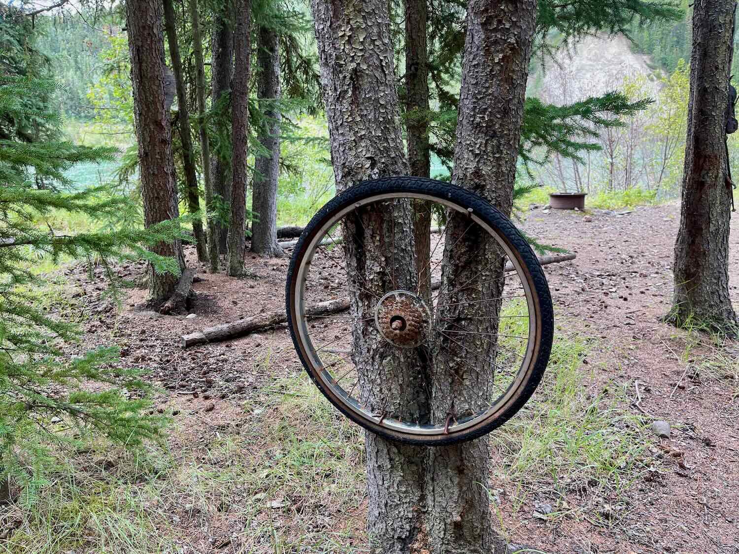
Part way through the ride we hauled the canoe on shore for a break near an old, ruined cabin. There we were amused to find an old bike tire fastened to a tree. Who knows what it might have been used for?

All in all, our first couple of weeks in Canada have been absolutely amazing. From battling the elements, to sweeping views of endless wilderness, to close encounters with majestic wildlife, every moment has been an adventure.