Cycling Argentina’s Route 40, Part 1: Junín de los Andes to Buta Ranquíl
21 March - 6 April 2025
21 March - Junín de los Andes to Catán Lil (47.7 mi, 76.8 km)
22 March - Catán Lil to La Amarga (31.5 mi, 50.7 km)
23 March - La Amarga to Zapala (48.8, 78.5 km)
24-25 March - Rest Days in Zapala
26 March - Zapala to Las Lajas (36.1 mi, 58.1 km)
27 March - Layover in Las Lajas
28 March - Las Lajas to R40 Wild Camp (43.6 mi, 70.2 km)
29 March - R40 Wild Camp to Chos Malal (23.0 mi (37 km) by bike, 32 mi (51.5 km) by car)
30 March-3 April - Wind days in Chos Malal
4 April - Chos Malal to Auquinco Wild Camp (29.5 mi, 47.5 km)
5 April - Auquinco Wild Camp to Buta Ranquil (25.8 mi, 41.5 km)
6 April - Rest Day in Buta Ranquil
The Northern Edge of Patagonia
Before departing on this bicycle journey, our knowledge of Patagonia (the region, not the outdoor clothing company) was pretty rudimentary. Like a lot of people, we knew that it basically encompassed southern Chile and Argentina. It was only after we started planning our trip that we began to grasp just how enormous the region really is. Estimates of its size vary. But even without precise numbers, Patagonia is bigger than 80% of the countries in the world.
For the past four months - since departing from Ushuaia - we had been living in, and cycling through Patagonia. Yet as we made our way northward, we began to wonder. Where, exactly, does Patagonia end? At what point would we officially leave Patagonia behind, and enter a new region?
It turns out that the answer to this question is not crystal clear. That’s because Patagonia is a ‘geographic concept’ - kind of like the American Great Plains, or Siberia - not an actual, administrative entity like a province or country. As a result, there have been different perspectives over the centuries on where to draw the northern border of Patagonia… or whether it is even appropriate to draw one at all. A google search for “map of Patagonia” yields surprisingly few helpful images, and even fewer that show the same northern boundary.
However, several authoritative sources cite a river that forms the border between two of Argentina’s provinces (just about 10 days ride ahead of us) as the northern extent of Patagonia. That seemed like a nice, concrete boundary. We decided to take that as our guide.
As we cycled towards the northern edge of Patagonia, the landscape gradually became drier. Valleys with meager vegetation were bordered by volcanic mesas, topped with grassy plateaus and buffeted by the region’s famously strong winds. Due to the harsh conditions, this part of Argentina remains only sparsely settled - resulting in long cycling days between lonely wild camps and small, dusty towns. Even the vegetation had a hard edge, with most plants sporting prickly burrs or long, dagger-like thorns - requiring extra care when cycling off-road (because of the danger of tire punctures) or choosing a spot to place our tent (out of fear of getting a puncture in our air mattresses). The very notorious “goatheads” (particularly pointy burrs) became common. There were a few times when we pulled 10-20 goatheads out of our tires, with each one leaving a small puncture that our tubeless tires would quickly seal.
This landscape is not for the meek, and some cyclists choose to endure the rain in Chile rather than brave the winds and thorns of Argentina. But we enjoy the wide, open spaces of the arid lands, and we felt like it was time for a change after plenty of cycling in the cold rain. We were ready to tackle Northern Patagonia.
Cycling Among the Mesas
Departing from Junín de los Andes, we got our first taste of how sparsely populated this part of Argentina was. The next town with any services was 130+ miles away (210+ km).
Luckily the first day’s weather was great - crisp in the morning, sunny with scattered clouds, and pleasantly cool in the afternoon. We were glad for the chilly breeze because shade had become very scarce. All of the vegetation was either grass or low thorn bushes. Trees were only found growing along streams (which were rare), or where people had planted them around a remote homestead or other ranch infrastructure. Apparently cows like shade when they are held in a corral.
Near the top of the first big climb of the day we had a panoramic view across a ranch, towards the mountains in the west. The Lanín Volcano was just visible on the horizon. Estancia Las Vertientes. Route 40, East of Junín de los Andes, Neuquén, Argentina. Copyright © 2019-2025 Pedals and Puffins.
Judging from the fairly thick forest along the banks of this river, it must have had a pretty good water flow all year. Away from water sources, there were no trees unless people planted them. Collón Curá River. Route 40, La Rincónada, Neuquén, Argentina. Copyright © 2019-2025 Pedals and Puffins.
A couple of hours into our ride we dropped into a valley, with two picture-perfect mesas ahead. Nearly everything on the landscape was brown - dark brown buttes with golden brown, dried grass on their flanks. Small herds of horses, cows and sheep were scattered wherever there was enough forage. PedalingGuy remarked that we had left Chile, and entered Wyoming - at least that’s the way it looked to us.
View towards the Chico mesas. The isolated, dark green woodland was a sure sign that there was a homestead among the trees (and that the trees were planted by people). The slight green wash to the grass in the valley was another indicator that there must be water near the surface down there. The Lanín Volcano can be seen between the buttes. Route 40, La Rincónada, Neuquén, Argentina. Copyright © 2019-2025 Pedals and Puffins.
From the valley our route slowly climbed up onto the top of one of the mesas. But where were all the guanacos and rheas? Both the llama-like guanacos and the ostrich-like rheas had been so common in southern Patagonia that we had expected to see them easily once we returned to the Argentinian steppe. But we had been cycling for hours, and had only seen domestic animals.
Just when we thought we might not see any guanacos, a small herd of just four animals appeared in the grassland on the plateau. We only stopped briefly to admire them, fully expecting to see more. But that was not the case. We didn’t see any more guanacos for the rest of the day - or even for the next couple of months. Sadly, a combination of poaching and competition with livestock has driven guanacos out of the area around Route 40. So that would be the last of them that we would see.
Groups of lesser rheas could still be encountered once in a while, though also in reduced numbers. The rheas can coexist with ranching better than the guanacos, but still suffer from poaching and collection of their eggs. The rheas that we saw along the route north of Junín de los Andes were extremely wary of people, and took off at a very fast gallop when PedalingGuy tried to get their photo. They didn’t stop running until they were a mere speck on the horizon.
This small group of Lesser Rheas sprinted away when PedalingGuy tried to take their photo. Poaching is a problem in some areas, and the birds have become extremely wary of people. Route 40, Near Catán Lil, Neuquén, Argentina. Copyright © 2019-2025 Pedals and Puffins.
As we traversed the top of the plateau, we were struck by the sight of several rusting hulks of cars along the side of the road. It wasn’t something we had seen in Chile or the other parts of Argentina we had visited. We wondered if it was just too hard to rescue a broken down vehicle from this remote mesa, causing cars to be abandoned, left to slowly decay under the Patagonian sun. Route 40, South of Catán Lil, Neuquén, Argentina. Copyright © 2019-2025 Pedals and Puffins.
The long descent off of the mesa-top led us to our destination for the night - a clump of tall cottonwoods behind an abandoned service station. Considering how few trees there were on the steppe, this was quite a prime camping spot. Amongst the trees there was a lot of evidence that plenty of other campers had spent the night there, before us. We didn’t have any trouble finding a nice, flat, hidden spot that was just big enough for our tent.
In fact the place seemed so well-used that we wondered whether someone else might show up to camp while we were there. But although several locals stopped for a rest break over by the abandoned building, no one else came back among the trees. It was nearly dark when we remembered that today was the equinox - when day and night are of equal length. For the next six months, the days would be shorter than the nights.
A lovely sunset, seen from our campsite among the cottonwood trees. Route 40, Catán Lil, Neuquén, Argentina. Copyright © 2019-2025 Pedals and Puffins.
Racing the Rain
The next morning, everything signaled that a change in the weather was coming. By 10am the sky was already clouding over. As we worked our way slowly up the side of another ridge, there was a burst of mid-morning warmth. But after that the day only got colder, assisted by the chill wind.
A herd of horses were intrigued by the sight of two cyclists passing by. The bushy, pale-green grass in the background was pampas grass. Route 40, North of Catán Lil, Neuquén, Argentina. Copyright © 2019-2025 Pedals and Puffins.
Ominous clouds gathered over the route ahead of us. Out on the pampas, there was nowhere to seek cover. Route 40, Near Estancia Don José, Neuquén, Argentina. Copyright © 2019-2025 Pedals and Puffins.
Near the bottom of the descent off the ridge, we were surprised to see two touring cyclists heading towards us, going south. Cyclists had become very scarce over the past few weeks, so we all stopped to say, “hola.” They were an engaging couple from a town near Buenos Aires, who were out on a multi-day tour. When we asked about their route, they laughed and explained that they were ‘wandering’ - criss-crossing back and forth across the country. It sounded like they were having a blast exploring their native land.
Eager for some intel on the road ahead, we asked them where they had slept the previous night. “There’s a little shop in the next village, and you can camp there,” they said. That was good news, because it was the site that we were aiming for. However, they then proceeded to tell us that the store was closed, dashing our hopes for an indoor refuge in case the coming rainstorm turned ugly. But they did reassure us that there was a good, flat spot to camp. We then wished each other a “buen viaje,” and set off in opposite directions.
Moments later we encountered one of our highlights of the day. As we cycled around a bend in the road, a shallow, saline lake came into view. Scattered throughout the water were the big, pink, fluffy shapes of flamingos! These birds can occur all the way down to Tierra del Fuego, but they had eluded us so far. They weren’t very close to the road, but fortunately flamingos are unmistakable. There must have been a lot of food in that little lake, because all the birds had their heads down in the water, eating. It took some patience to wait for a few of them to raise their heads so we could get a distant photo.
We had to wait until we were back in Argentina to finally see some Chilean Flamingos. It was a big thrill to see about 100 of these goofy, gorgeous birds feeding in a shallow lake. Route 40, Lake La Nedra, Neuquén, Argentina. Copyright © 2019-2025 Pedals and Puffins.
As we got closer to the village of La Amarga the sky became fully overcast, and we could see the telltale haze of rain falling in the distance to our east. It felt like we were racing the rain, so we picked up our pace. It appeared that we had not yet left the rains behind. But we would soon find out just how different rain storms in this part of Argentina can be from those in Chile. The slow drizzle of Chile would be replaced with violent storms that brought intense rain and wind, often leading to flooding as the water poured out of the mountains and into the arid landscape.
The approaching weather front brought a thick, gray layer of clouds. Grass fronds along a dry riverbed waved in the wind. Route 40, Arroyo China Muerta, Neuquén, Argentina. Copyright © 2019-2025 Pedals and Puffins.
We arrived at the little village of La Amarga (pop. <50) in the early afternoon. Although no one was at the closed store, we could hear some people talking near a house just behind it. So PedalingGal went back to ask them if it was okay to camp. There she met, Daniel, a very friendly neighbor. He said that we were welcome to camp anywhere.
However, he seemed concerned about the incoming storm, and asked if we would like to camp under a roof. That sounded very appealing. Daniel then led PedalingGal to his drafty wood shed, and said we were welcome to pitch our tent inside. But the space clearly was also used by his sheep, chickens, dogs and cats to get out of the weather - as evidenced by the fact that the floor had a thick coating animal droppings. She declined the very kind offer.
In a hurry to pitch our tent before the rain came, we quickly chose a spot for the tent under a cluster of trees near the small store. We had some trouble because the gravel earth was rock-hard, making it especially difficult to drive our tent stakes into the ground. Little did we know that we had essentially pitched our tent on a substance like dry cement mix, that would turn into a mushy slurry when wet. Then we gobbled down a couple of peanut butter and jelly sandwiches for dinner - rushing because the rain seemed imminent. We felt very lucky that we finished dinner, and got everything stowed safely inside the tent in the nick of time.
Ten minutes later (around 5pm), the storm began. Everything was cold and damp from the moisture in the air, so we decided to just change clothes and snuggle down into our sleeping bags. We were glad to be warm and (mostly) dry.
But we had made a couple of strategic errors. The first was that although we had chosen a spot for the tent among some trees, the only side on which we did not have any wind protection was the side from which the storm blew in. Before long it was raining steadily, with huge gusts of 40-50 mph winds that caused the tent to heave and groan. With each blast of wind, the lower edge of our outer tent fluttered so rapidly it sounded like a growling animal. The vibrations also threw water around, splashing it onto the mesh of our inner tent. Soon everything stowed along the edges of the tent was getting wet. We covered our belongings with our rain jackets to try to keep them from getting fully soaked.
About a half hour into the storm another, lone cyclist arrived from the north, drenched by the rain. At that time someone was in Daniel’s wood shed chopping wood - probably to warm their cabin that night. The cyclist headed towards the sound of the chopping, and we could hear them greet each other. We never saw where the other cyclist ended up that night, but he probably opted for staying in the shed with the sheep, chickens and dogs.
As the light faded around sundown, we began to drift off to sleep. But that’s when our second, strategic error became clear. We had expected the wind to die down at night (as had been typical the last few days), even if the rain continued. So in our haste to pitch the tent, we hadn’t bothered to use any extra guy lines to secure the tent against the wind. But instead of decreasing, the wind only increased in intensity as the evening wore on.
And remember how we had driven the tent stakes into the hard gravel? By nightfall the gravel was a loose mush. Around 9:30pm disaster struck: a stake holding down a corner of the tent facing the wind pulled out of the ground. Without the support of the stake the central tent pole started to fall over, leaning away from the wind, and the waterproof outer tent blew aside, leaving us completely exposed to the weather. Water started streaming in through the mesh, and the tent began to collapse around us.
As in the past when things got bad, PedalingGuy sprang into action. He grabbed his raincoat and head lamp, and went out into the driving rain to try to fix the tent. Somehow he managed to re-stake the corner that had come loose. He also reinforced another tent stake on the same side. Then, taking extra time, he secured two additional guy lines on that side to provide reinforcement against the wind.
All of this took considerable time, and he was thoroughly soaked when he got back inside the tent. His base layer and socks were drenched, so he ended up having to sleep in his dirty cycling leggings, which was a real drag. Fortunately, the raincoat had kept his shirt dry enough and his sleeping bag had stayed toasty, so he was able to warm up again with relative ease. That was a relief, because the rain outside was very cold.
The good news was that his sacrifice worked like a charm. Even though the powerful wind and driving rain were unrelenting until well past midnight (when it finally changed into moderate rain and wind), the tent stakes held for the rest of the night. And one helpful thing we can say about the rain… it seemed to subdue the crowds of dogs and chickens nearby. Aside from the rain on a nearby tin roof, it was a relatively quiet night.
A Refuge in the Wilderness
In the morning, it seemed like nothing we could do would keep us warm. As we cycled away, the sky was still fully overcast and a deep chill settled into our very bones - made even more biting because of the damp air. Our hands, in particular, felt icy cold.
According to our map, there was a cafe located about 45 min up the road. But we tried hard not to get our hopes up too much. So many times we had found these remote businesses closed when we arrived - often with no explanation. They just aren’t that committed to keeping regular hours. Who could blame them, so far from any other signs of civilization, with very little traffic along the road?
Imagine our ecstasy when we arrived at the cafe and discovered that they were open! In a flash we had settled inside and ordered up a hearty breakfast of eggs, fried bread and tea. They didn’t have much other than what we ordered, but you stop being choosy about such things when you are in remote areas. We also polished off a 2.25L bottle of apple water (yes they call it apple water, or just water, here since it is highly diluted apple juice). We throughly enjoyed our meal. Little by little the ice in our bones started to thaw, and our ravenous hunger and thirst started to fade. It was AMAZING.
We lingered over that breakfast as long as possible, but eventually had to tear ourselves away. We still had a lot of miles to cover, and the sky still looked unsettled.
The Bumpy Road to Zapala
Over the next five hours of cycling, the biggest challenge came from the rotten condition of the road. The surface was riddled with potholes, embellished with ad hoc speed-bumps wherever the maintenance crews had slathered on tar for spot repairs. Frankly, it wasn’t much better than cycling on rough dirt. We had to concentrate to avoid the worst of the craters, and to avoid falling off the crumbling edge of the tarmac into the mushy gravel shoulder. Having to focus so much on the road meant that we couldn’t appreciate the scenery very well while riding. Every so often we would stop for a ‘vista break,’ and soak up the big, sweeping views.
View from the rim of a high mesa. It kept threatening to rain, but we were spared - with just a few periods of light rain and mist. Route 40, South of Zapala, Neuquén, Argentina. Copyright © 2019-2025 Pedals and Puffins.
The changing leaves on the saffron-tinged cottonwoods along the Santo Domingo River were another reminder that autumn was approaching quickly. Route 40, South of Zapala, Neuquén, Argentina. Copyright © 2019-2025 Pedals and Puffin
We had just started the final climb of the day when we saw another cyclist barreling down the hill towards us. He was moving fast, but when he saw us we heard the squealing of his brakes as he careened over to our side of the road to greet us. Ernesto (from Chile) was positively bursting with youthful energy and immediately started asking a series of rapid-fire questions: What were our names? Where were we from? How old were we? Where did we start our trip? Where were we going?… Could he take a photo? No wait, could he take a video?
As the roadside interview unfolded his cycling companion, Daniel (from Argentina), rolled up and he was just as gregarious as his buddy. They seemed eager to document our encounter with as much speed and enthusiasm as they had been cycling. We did manage to gather that they were on different trajectories, but had connected with each other as riding companions along this stretch of Route 40. Ernesto had been on the road 2.5 months and was aiming for southern Chile. Daniel already had been out cycling for 7 months, and hoped to make it all the way to Ushuaia in Tierra del Fuego. Given that it was already pushing the end of March, he was definitely going to arrive there in winter (brrr).
But what really amazed us was that they planned to cycle all the way to Junín de los Andes TODAY. It was already 3pm, and they still had ~120 miles (195 km) to go. Even with their skinny tires, light weight set-ups, a tailwind and boyish energy, it would still take them 6+ hours to go that far. They would certainly not make it before dark. But they seemed totally unfazed, and they clearly relished the challenge. After less than 10 minutes of visiting (time was of the essence for them), they jumped back on their bikes and bounded away.
A quick, roadside visit with Daniel (from Argentina) and Ernesto (from Chile). Their boisterous energy was infectious. We were impressed that they were dressed light (note Ernesto’s shorts), while we were wearing multiple warm layers against the cold, damp air. Route 40, South of Zapala, Neuquén, Argentina. Copyright © 2019-2025 Pedals and Puffins.
Relief from cycling on the bumpy road came in the final 30 min of our ride, in the form of a paved bike path that paralleled the highway. This was an unexpected treat - although since we were approaching a fairly large town, it was not totally out of context. Not only did the path get us away from the traffic, but the surface was smooth as silk - much better than the condition of the road. It was nice to see a few local cyclists and runners out getting exercise on the path, too.
A Frontier, Railroad Town
The town of Zapala itself (pop. 31,500) seemed eerily quiet when we arrived. It was during the siesta time on a Sunday, which is often a low-key time throughout Latin America (outside of big cities, everything shuts down between 2-5pm daily in Argentina). But still… the streets were deserted. Imagine an old Western-style movie, where the protagonists roll into a frontier town on their (steel) horses and find nobody around. Compared to other towns of its size that we had visited, Zapala just didn’t feel like it was thriving.
Finding something for dinner that evening proved to be fairly straightforward, because there really was only one restaurant. They didn’t start serving proper dinners until 8pm. But at least they were open when we showed up at 6:30pm, and we could order from their ‘fast food’ menu.
After perusing the menu, we decided to get beef milanesa sandwiches. However, when we attempted to place an order for two sandwiches, the waiter became quite animated. He explained that would be way too much food, and started gesturing with his hands to show us just how big one milanesa sandwich would be. In his view, one sandwich was enough to feed an entire family.
Given that Spanish isn’t our first language, it took us a while to be absolutely sure that we really understood what he was trying to tell us. After all, two hungry cyclists can put away a lot of food, so the last thing we wanted to do was under order during our first night in town. Yes, he assured us, it would be plenty. So we went ahead and ordered just one sandwich, plus a side of fries to share.
Our gigantic milanesa sandwich, big enough to feed two hungry cyclists. It was a good thing we took the waiter’s advice, and didn’t order two of those mega sandwiches. Zapala, Neuquén, Argentina. Copyright © 2019-2025 Pedals and Puffins.
When we discovered that the wifi in our rental apartment was really fast and steady, our planned rest day suddenly became two. One thing we’ve learned after years of bicycle travel is to never squander access to great wifi connectivity.
That ‘quiet, frontier town’ feeling extended into our first full day in Zapala. It was a holiday - the somber Day of Remembrance for Truth and Justice which is dedicated to the memory of victims of the country’s brutal dictatorship (which ended in 1983).
As we walked around the nearly empty streets, the central role of the railroad in the town’s history was apparent. Although the trains stopped running some time in the last 15 years, the town served as the western terminus of an important agricultural freight line that ran to Buenos Aires for a century. To this day, the town is bisected by a wide, grassy, railroad right-of-way (complete with decaying train tracks) that separates the residential and commercial districts. Although the vacant land had a traveling circus set up on one end, it seemed largely under-utilized as a public space - with few amenities like benches or landscaping that would invite people to linger.
This silhouette painted on a building near the old railroad corridor seemed to capture the melancholy, yet resilient spirit of the town. Zapala, Neuquén, Argentina. Copyright © 2019-2025 Pedals and Puffins.
A statue within a big traffic circle honored the first European settlers in the area. A man in gaucho dress led a team pulling a classic ox cart, carrying his wife and child. Their stoic appearance conveyed the fabled strength of spirit attributed to early pioneers. Not too different from the pioneers who settled the American West. Zapala, Neuquén, Argentina. Copyright © 2019-2025 Pedals and Puffins.
Like most local history museums, the one in Zapala was in many ways a big collection of stuff donated by the local population. The museum doesn’t get many visitors so everyone gets their own personal guide. Although our tour guide only spoke Spanish, he made a great effort to make sure we understood all the items on display. Our favorite artifact was a giant, antique film projector that was used in the local cinema until the 1950s. Zapala, Neuquén, Argentina. Copyright © 2019-2025 Pedals and Puffins.
The Birds
As we cycled northward from Zapala we noticed a big change in the landscape. All of the mesas and buttes were gone. Instead we found ourselves cycling through broad, sandy valleys bordered by dusty-brown, rounded, gravelly hills. The vegetation became even more sparse, with extensive sand and gravel between each, miniature bush. There were some hints of larger mountains to the west, but the air was quite hazy all day, washing out any views in that direction.
Plants clearly had a hard time growing here. We were surrounded by khaki-colored hills with just patchy, muted-green vegetation. Route 40, Covunco River Valley, Neuquén, Argentina. Copyright © 2019-2025 Pedals and Puffins.
A lonely homestead out-building, among the tufts of last year’s grass. Route 40, South of Las Lajas, Neuquén, Argentina. Copyright © 2019-2025 Pedals and Puffins.
A roadside offering of thanks, now serving as a shrine for other travelers who seek blessings. Route 40, South of Las Lajas, Neuquén, Argentina. Copyright © 2019-2025 Pedals and Puffins.
Our arrival in the town of Las Lajas, another frontier outpost in western Argentina. Route 40, Las Lajas, Neuquén, Argentina. Copyright © 2019-2025 Pedals and Puffins.
It was mid afternoon when we rolled up to the cheerful cluster of cabins where we would spend the night in Las Lajas (pop. 5,230). For a moment, we could have been forgiven for thinking we had passed through a teleportal, and arrived somewhere in Central America. In our experience, Argentinians living on the western frontier were not prone to flashy displays of color. As a general rule, the exteriors of buildings were left in their natural colors, or painted in very neutral colors (white being the notable exception). But at Cabañas Navi, each little cabin was painted in its own, vivid color, giving the complex an almost-tropical ambiance.
The eye-catching colors of the rental cabins in Las Lajas. We stayed in the green one. Route 40, Las Lajas, Neuquén, Argentina. Copyright © 2019-2025 Pedals and Puffins.
Aside from the dazzling paint job, the little cabins were fairly standard lodging for this part of the world. However, around 7:30pm, as sunset approached, we became aware of another unique feature of this town - the birds.
It started innocently enough, when we walked to the town center to buy some groceries. Along the way we noticed a handful of small flocks of burrowing parakeets (8-10 birds) flying above the streets of town. They’re very cool birds and were still relatively new to us at that time, so seeing them in town was a treat.
However, as evening approached we noticed that many of them had started congregating in the tall Black Poplar trees that lined the cabin’s property. Just like in the Alfred Hitchcock movie The Birds, what began as a trickle of small flocks soon turned into a flood. And by sundown (around 7:45pm) the trees had become a giant, seething, squawking cauldron of gregarious parakeets.
So, if they were burrowing parakeets, why were they in the trees? From time immemorial, these birds have nested in burrows (which they dig in soft, limestone gravel cliffs). But they have always spent the off-season roosting in tall trees. Where do the tall trees grow in arid lands? Where do people establish towns? The answer to both questions is near water sources. This has caused a clash of people and birds.
Before the arrival of Europeans tall trees would have been scarce and, as mentioned, clustered along waterways - encouraging the parakeets to adapt to roosting together in big flocks. These days the riverside trees are in even shorter supply, since many were chopped down by pioneers for wood, or dried out as water was diverted away for agriculture. If you are a bird looking for a place to roost, the new ‘forests’ of Black Poplar that grow in towns and around homesites offer one of the few alternatives.
Estimates vary, but the flocks of parakeets that spend their fall and winter nights roosting in Las Lajas’s trees easily numbered 10,000 birds (at least double the human population). Besides the loud volume of the roost, we’ve heard that the birds can cause other headaches for the local humans. Apparently it’s common for the parakeets to chew on electrical wires with their oversized beaks, causing power outages. With thousands of birds screeching to each other at the same time, it looked like it was going to be a very noisy night.
Flocks of Burrowing Parakeets started to gather in the tall trees near our cabin. Route 40, Las Lajas, Neuquén, Argentina. Copyright © 2019-2025 Pedals and Puffins.
And so it was. Although the parakeets were roosting for the night, sleeping did not seem to be a priority. Huge numbers of the birds continued their social visits, catching up on news from the day before, all night long. They were easily as loud as an all-night, Latin American dance party (which, if you’ve never heard one, is really, really loud). We were very lucky that our earplugs seemed to be particularly well suited for cutting out noise at the frequency generated by the parakeets. With earplugs, we were able to get some sleep.
On our rest day we went for a pleasant walk to the Las Lajitas Natural Reserve, a small natural area at the edge of town that encompasses a slow-moving section of river with a big, marshy, wetland fringe.
The road to the nature reserve was unpaved, winding through suburban farmland. Route 40, Las Lajitas Natural Reserve, Las Lajas, Neuquén, Argentina. Copyright © 2019-2025 Pedals and Puffins.
The horses and ponies corralled near the houses were very friendly, probably hoping for a carrot or other treat. Route 40, Las Lajitas Natural Reserve, Las Lajas, Neuquén, Argentina. Copyright © 2019-2025 Pedals and Puffins.
Most of the birds we saw in the marsh were familiar to us from places like Buenos Aires. The one, new species we saw was a Picui Ground-Dove. They were quite plain, but it still was fun to see something new. Route 40, Las Lajitas Natural Reserve, Las Lajas, Neuquén, Argentina. Copyright © 2019-2025 Pedals and Puffins.
A check of the weather forecast before departing Las Lajas yielded some sobering news. We had another 100+ mile stretch of road to reach the next town with any services - which would take us 2.5 days. However, we learned that a big weather system was forecast to blow in on the afternoon of the third day, bringing strong winds. With this in mind, we planned our rides to include two longer days up front, with a much shorter ride into the town of Chos Malal on the third day - hopefully getting us to safety before the storm became a problem.
Remnants of a Distant Past and Signals from Distant Space
The road out of Las Lajas headed eastward, taking us further away from the mountain foothills and out into the desert. For two hours we cycled deeper onto the increasingly arid landscape, before turning north again. But along the way there was evidence that this region wasn’t always so dry. In one sandy arroyo, the petrified trunks of large, Triassic era trees could be found among the gravel layers. At that time early dinosaurs wandered among the big trees that lined major water courses, before the continents of Africa and South America split apart. Further along our route the fossils time-traveled to the Cretaceous era 50-million years later, when the climate was much warmer and central Argentina was a shallow ocean. The fossil clams would have lived their lives buried in the sandy bottom of this shallow sea.
It was a beautiful day for cycling - cool but sunny, with high clouds and not too much wind. We took our time, enjoying the scenery and tranquility of the region. It hardly gets any better.
The area just east of Las Lajas is known for its large specimens of petrified trees. Fossil hunters go prospecting in this arroyo for those remnants of an earlier time. Route 40, Arroyo Pyrámide petrified wood site, Neuquén, Argentina. Copyright © 2019-2025 Pedals and Puffins.
A rock encrusted with fossil clams indicated that this dry land was once a shallow sea. Route 40, Salado River Valley, South of Chorriaca, Neuquén, Argentina. Copyright © 2019-2025 Pedals and Puffins.
These days, any bit of water can transform the landscape. This homestead on the far side of a river valley must have had some water near the surface, supporting a grove of trees and even a patch of green grassland that looked anomalous among the beige hills. Route 40, East of Las Lajas, Neuquén, Argentina. Copyright © 2019-2025 Pedals and Puffins.
Pondering the tranquility of the landscape, and how hard that last hill was to get up. On a ridge that bordered the Salado River Valley. Route 40, East of Las Lajas, Neuquén, Argentina. Copyright © 2019-2025 Pedals and Puffins.
Along the way we had an encounter that drove home just how ‘out of the way’ this section of road was. There had been relatively few cars. But at one point a red car pulled up close behind us and tried to flag us down. At first we thought he was just being friendly, so we waved back. But then he sped around us, pulled off the road up ahead, and hopped out to talk to us.
He told us he was lost - and asked if this was really Route 40. He was trying to get to the town of Chos Malal, but he hadn’t seen any road signs to indicate what road he was on, or what towns were up ahead, so he had started to worry. He seemed quite flustered, and his relief was palpable when we reassured him that he was on the right road, heading in the right direction. Then he jumped back in his car and sped off.
Given that we hadn’t seen any other roads in days, it was curious to us that someone could get lost. However, since there was no cellular signal out there to reassure people with an online map, and paper maps seemed to be almost nonexistent, perhaps that explained his angst.
Not long after that we saw something really odd out on the valley floor to our left. Through our binoculars it looked like a very, very big satellite dish. We couldn’t see any other infrastructure around it, but apparently there is a Chinese research station there (a.k.a., the Chinese Deep Space Station). The dish is used to connect to a satellite whose role, in part, is to communicate with the Chinese lunar module exploring the dark side of the moon. Although Argentinian space scientists are allowed to use the installation for research as well, the site seems quite controversial because it is affiliated with the Chinese Army.
Like a big, lacy, white flower, the satellite antenna at the Chinese Deep Space Station really stood out in the desert. Route 40, Salado River Valley, Neuquén, Argentina. Copyright © 2019-2025 Pedals and Puffins.
When we arrived at our intended camping spot, we were sorely disappointed. We often rely on an app called iOverlander (a crowdsourced resource for adventure travelers) to guide us to likely spots for wild camping, and usually they’re pretty good. We knew from the online description that this site was a road culvert. But upon inspection it didn’t seem like a very good camping locale at all - it wasn’t even a particularly good road culvert. There weren’t any spots for our tent that wouldn’t be visible from the road. We decided to try our luck and keep going.
Fortunately we didn’t have to go much farther. In just a half hour we found another drainage that had a nice berm that paralleled the road, which was just tall enough to hide our tent. On the other side of the berm was a large, flat space, ideal for camping. The only red flag was that there were lots of gullies around, indicating that the area might flood in a big rainstorm. But since there was no rain forecast, we decided to go for it.
Sunset cast a warm glow on the surrounding hills near our campsite. The gravel berm just beyond our bikes blocked our tent from the view of passing cars. Route 40, Salado River Valley, South of Chorriaca, Neuquén, Argentina. Copyright © 2019-2025 Pedals and Puffins.
The sun dipping behind the mountain ridge to our west. Route 40, Salado River Valley, South of Chorriaca, Neuquén, Argentina. Copyright © 2019-2025 Pedals and Puffins.
A Roadside Rescue
The next day got off to a great start. Much like the day before, the wind was very calm and it looked like it would be a perfect day for cycling. We were particularly tickled to see a set of unusual tracks in the dusty earth just a few feet from our tent. It looked like a small dinosaur had walked past during the night - but it probably was a rhea. Still, it was fun to see the tracks in the morning, and imagine the big bird tiptoeing by in the dark.
Pushing the bike back to the road, from our campsite behind the gravelly berm. Route 40, Salado River Valley, South of Chorriaca, Neuquén, Argentina. Copyright © 2019-2025 Pedals and Puffins.
However, we were surprised that in less than an hour after our start, we were cycling into a bit of a headwind. Based on the weather report from two days ago, we had expected it to remain calm for most of the day. It was an unwelcome development.
The first 2.5 hours of cycling brought us to the top of a big ridge. At the summit, we stopped for breakfast. We both noted how the wind died down once we crossed the top of the pass. It seemed like a good omen.
Along the route to the top of a ridge, we passed the small village of Chorriaca - a traditional Mapuche community that governs their communal land following ancestral practices. This sign by the road, which had no text, was the only indicator of where to turn to reach the village. Route 40, Chorriaca Junction, Neuquén, Argentina. Copyright © 2019-2025 Pedals and Puffins.
Things were going great. We had a delightfully fast descent off the pass, and were more than halfway to our destination (a restaurant with a campground). With no more big hills ahead, we looked forward to an afternoon of gently rolling terrain.
Around 12:30pm we stopped for a quick rest break. However, during the 10 minutes we were stopped, the wind started to pick up again. PedalingGuy, as if having a premonition, remarked that we should get going again, before the afternoon wind became a problem.
Little did we know how hopeless that would be. It was as if someone had flipped a switch. Within the next 15 minutes we were cycling into one of the most brutal headwinds we had ever encountered. It was like cycling in a hurricane (without any rain). We struggled to stay upright on our bikes, and we both were in a bit of shock about how quickly our circumstances had changed.
With nowhere to hide - no hills, no trees, just the wide open desert - we plowed forward directly into the wind. Even though we were on level ground it was very difficult to make any forward progress. It took us 40 minutes to go 1.5 miles, too slow for our odometers to even register the speed. Occasionally the wind would blow so hard it would stop us completely, and we would have to shelter our eyes or look behind us to prevent being pelted in the face by dust and small stones. That made us realize the exceptional intensity of the wind. We had been in many wind storms before, but never any that sprayed us with small stones. Slowly the realization set in that the big weather front we had expected to arrive on the third day had, in fact, shown up a day early.
When you are in the middle of the desert in a seriously raging wind storm, there are not many options. This particular desert had very little vegetation higher than your knee. At the pace we were traveling we would not be able to make it to a place with shelter before it got dark and very cold. Worse, the forecast for the weather front had included another bout of rain. That could make camping in any drainages or road coverts risky, given the possibility of flash floods. If we had to spend the night in the desert we probably would not be able to set up the tent, because even through our tent is considered one of the best in strong winds, we didn’t think any tent (including ours) would be able to survive the gale force of the wind we were encountering. As we pushed on, PedalingGuy started to look for any ditches that might be able to provide some cover. Unfortunately, none could be found - not even a road culvert.
We stopped on the side of the road to take stock. Usually when something goes wrong or there are challenging conditions you can think your way out of the problem and come up with alternatives to mitigate the issue. But not in this case. We felt helpless - unable to come up with any solutions other than spending a very uncomfortable night huddled together, wrapped in a tarp, in the open desert, as the wind and rain pelted us. This involved the risk of hyperthermia, given the low nighttime temperatures in this area. Simply trying to push through the wind all night also risked hyperthermia, as our bodies grew tired through the night.
We decided to push forward, since we really didn’t have any other ideas at the moment. Maybe the wind would let up? We were mostly walking our bikes, unable to pedal upright in the intense winds. Pretty soon we were covered with sand. By 2pm, things were not looking good.
Then heaven sent an angel to our rescue. A gorgeous, white pickup truck pulled over in front of us. The driver got out and made our day by offering us a ride. We could hear the angles sing! The bikes would fit in the bed of the pickup truck, and we could ride inside the cab of the truck with the driver and his wife. This was definitely a no-brainer. It took us just a moment to accept the offer.
The fact that we chose to take the ride so quickly is a reflection of just how bad we thought our circumstances had become. We almost never take rides with our bikes, except in dire situations. In Mexico we took a bus for 50 miles to skip an active war zone between the cartels and Mexican authorities. In Ethiopia we took a ride when Covid got so bad that we had to evacuate the country. But that’s about it. When we are on a bike trip we try to stay on our bikes and deal with things. That is all part of the experience for us.
Chatting with the driver of the pick-up truck, we learned that the wind was blowing at 60 mph (100 kph). Initially we asked for a lift just as far as the campsite we were targeting, which was rumored to have some trees that we could shelter behind. But they made it clear that they thought we were crazy to try to camp in this weather, and strongly encouraged us to consider riding with them all the way to the next town.
Our bikes, piled in the back of our saviors’ pickup truck. Route 40, South of Chos Malal, Neuquén, Argentina. Copyright © 2019-2025 Pedals and Puffins.
At first we declined. But the more we thought about it, we started to reconsider. The wind was truly fearsome, whipping up the sand into a brown haze. If it rained (as predicted) it could be a miserable night. Finally, we accepted their offer for a lift all the way to town.
They were incredibly generous, and brought us all the way to the central plaza in Chos Malal, which was just a couple of blocks from the apartment where we had a reservation for the following night. We crossed our fingers, hoping the owner could let us into the apartment a day early, and were thrilled when they said, yes. We had a bit of a wait while they prepared the room, but were able to go inside around 3:30pm.
The wind howled all night, and the storm unleashed buckets of rain for several hours in the morning. We were very glad to be safely indoors. It turned out to be a good decision to go all the way to town since the wind whipped for a couple days and would have made it difficult to do anything other than walk our bikes into town, a slow difficult journey.
Layover in The River City
We spent the next few days in Chos Malal (pop. 20,000), waiting for the wind to subside. Located at the confluence of the area’s two biggest rivers, the town’s main attraction is a waterfront park and 2-mile long (3.2 km) riverwalk. Nearly every day we took a long stroll that included the riverside path. Most of the time it was quiet, making it an ideal circuit for checking out the local birdlife. However, on a Sunday we found the waterfront crowded with people engaged in a local race. It was fun watching the runners come in.
A couple of runners victoriously cross the finish line of a 5K/10K race. Paseo Costanero, Chos Malal, Neuquén, Argentina. Copyright © 2019-2025 Pedals and Puffins.
Chos Malal was originally established as a frontier fort to help police cattle rustling in the region. The restored tower of the fort sits high on a hill overlooking the river, while the lower fort building now houses the provincial museum. Paseo Costanero, Chos Malal, Neuquén, Argentina. Copyright © 2019-2025 Pedals and Puffins.
Most mornings the riverwalk was mostly deserted, making for a lovely, tranquil place to walk. The El Tromen Volcano, which has been dormant since 1822, rises in the background. Paseo Costanero, Chos Malal, Neuquén, Argentina. Copyright © 2019-2025 Pedals and Puffins.
The river near Chos Malal was shallow, gravelly and braided, like many glacier-fed waterways. On the far side was a farming community with lots of the tall Black Poplar trees that are the favored wind-breaking tree in Argentina. Judging by the small flocks of burrowing parakeets we saw regularly flying in that direction, we guessed that they probably had their own, large parakeet roost over there. Fortunately, it was far from where we were staying so we didn’t have to endure the noise of the birds at night. Paseo Costanero, Chos Malal, Neuquén, Argentina. Copyright © 2019-2025 Pedals and Puffins.
One bird that was surprisingly common along the waterfront was California Quail. Introduced from Chile in the 1920s, the quail have become locally abundant in the Neuquén Province, and are a prized game species. Fortunately, there have not been any negative effects documented as a result of the introduction, and the quail may actually help improve soil health through their foraging behavior. Paseo Costanero, Chos Malal, Neuquén, Argentina. Copyright © 2019-2025 Pedals and Puffins.
It was only here, as we approached the northern edge of Patagonia, that we spotted our first Patagonian Mockingbird (largely because the species is rare in Chile, where we spent most of our time). Paseo Costanero, Chos Malal, Neuquén, Argentina. Copyright © 2019-2025 Pedals and Puffins.
Burrowing parakeets, just sitting on the wires (rather than chewing on them). Paseo Costanero, Chos Malal, Neuquén, Argentina. Copyright © 2019-2025 Pedals and Puffins.
Burrowing parakeets were so common in town, we figured there must be a big roost nearby. Paseo Costanero, Chos Malal, Neuquén, Argentina. Copyright © 2019-2025 Pedals and Puffins.
One project we attempted while in Chos Malal didn’t quite go as planned. On one of the nights that we had camped in the desert, the zipper on our outer tent broke. Well, it didn’t just break by itself. The zipper wasn’t closing properly (the teeth kept separating) so we had attempted a field repair by squeezing the zipper pull with a pair of pliers at camp - something we have successfully done in the past. Unfortunately, we squeezed too hard, which caused the zipper to become unusable. So, now it was genuinely broken.
Once we were in town, the plan was to try and loosen the grip of the zipper pull with our tools. With a little bit of fiddling we managed to loosen the zipper pull, which brought it back to life. That gave us hope. But when we tried to tighten it to the proper tension, the zipper pull snapped in half. That was the end of it. No more zipper pull.
Fortunately, we had been carrying a couple of spare ‘universal’ zipper pulls since Mexico. These ingenious devices can be manually added to miraculously replace almost any zipper pull. They’re not perfect, but they work nearly as well as the original zippers, and don’t require taking apart/resewing the seams of the tent, which is normally needed to replace a zipper. Since tent zippers frequently fail, we highly recommend that cyclists and others who need to rely on a tent take a spare. There is nothing worse than a failed zipper on a tent. Here is a link for the one that we use (zipper pull replacement). In this case it was a true lifesaver. At least we would continue to have a working tent. (Note: we have no relationship with the manufacturer, and this is not an affiliate link. We will not receive any payment for click-throughs from our site.)
Our other adventure in Chos Malal gave us a chance to pay back a little of the generosity we had received when the pickup truck rescued us from the wind. We were walking through a residential part of town when we saw a young guy trying to push a small car out of a driveway and into the street. At the wheel of the car was a woman who looked like she was probably his grandmother. He was pushing slightly uphill, and it looked like he might not have enough strength to get the car over the hump. PedalingGuy offered to help. Even with the two of them pushing together, with all their strength, it was a big effort.
When the car was finally in the road the lady actually offered us a ride into town. That was sweet, but struck us as a bit premature since her car wasn’t actually running yet. We preferred to walk anyway, so we declined.
The next thing we knew, the young guy started pushing the car forward and the driver accidentally steered the car into a ditch on the side of the road. One of the front wheels was left hanging limply over the ditch. Stuck again.
So PedalingGuy went back to help a second time. This time PedalingGal truly wondered if they would be able to get the car out of the ditch, because in addition to having to push the whole car backwards, uphill, they had to lift the front end (with the weight of the engine) high enough to get the dangling wheel up and over the edge of the ditch. It was a massive effort that took at least five minutes of shoving and lifting. But eventually the car was set free.
Next PedalingGuy and the young man pushed the car as fast as they could down the dirt road, while the lady popped the clutch a couple of times to try to start the car. Nothing worked. Truthfully, there was no evidence that the car would ever start. So they pushed it to the side of the road and we parted ways. From what we understood, they were going to call another friend to give her a jump start. We wished them well.
Sharing the Road with Goats and Cows
Our first day out of Chos Malal was a pretty big day of cycling. At roughly 30 miles (50 km) the distance wasn’t the issue. However, it was an ‘all uphill’ day requiring 3,500 ft of climbing up onto a high plateau. The folks in passing cars seemed to appreciate that we were tackling a big climb. Drivers were even friendlier than usual, often tapping their horns and waving in encouragement as they drove by.
The climbing began right away as we left Chos Malal, offering fantastic views back down into the river valley. With autumn approaching, the cottonwoods along the river banks had turned a soft gold. Chos Malal, Neuquén, Argentina. Copyright © 2019-2025 Pedals and Puffins.
A little over an hour into our ride we stopped for a break at this miniature, rural bus stop. Even while we were resting, passing drivers would honk and wave in encouragement. Route 40, La Salada, Neuquén, Argentina. Copyright © 2019-2025 Pedals and Puffins.
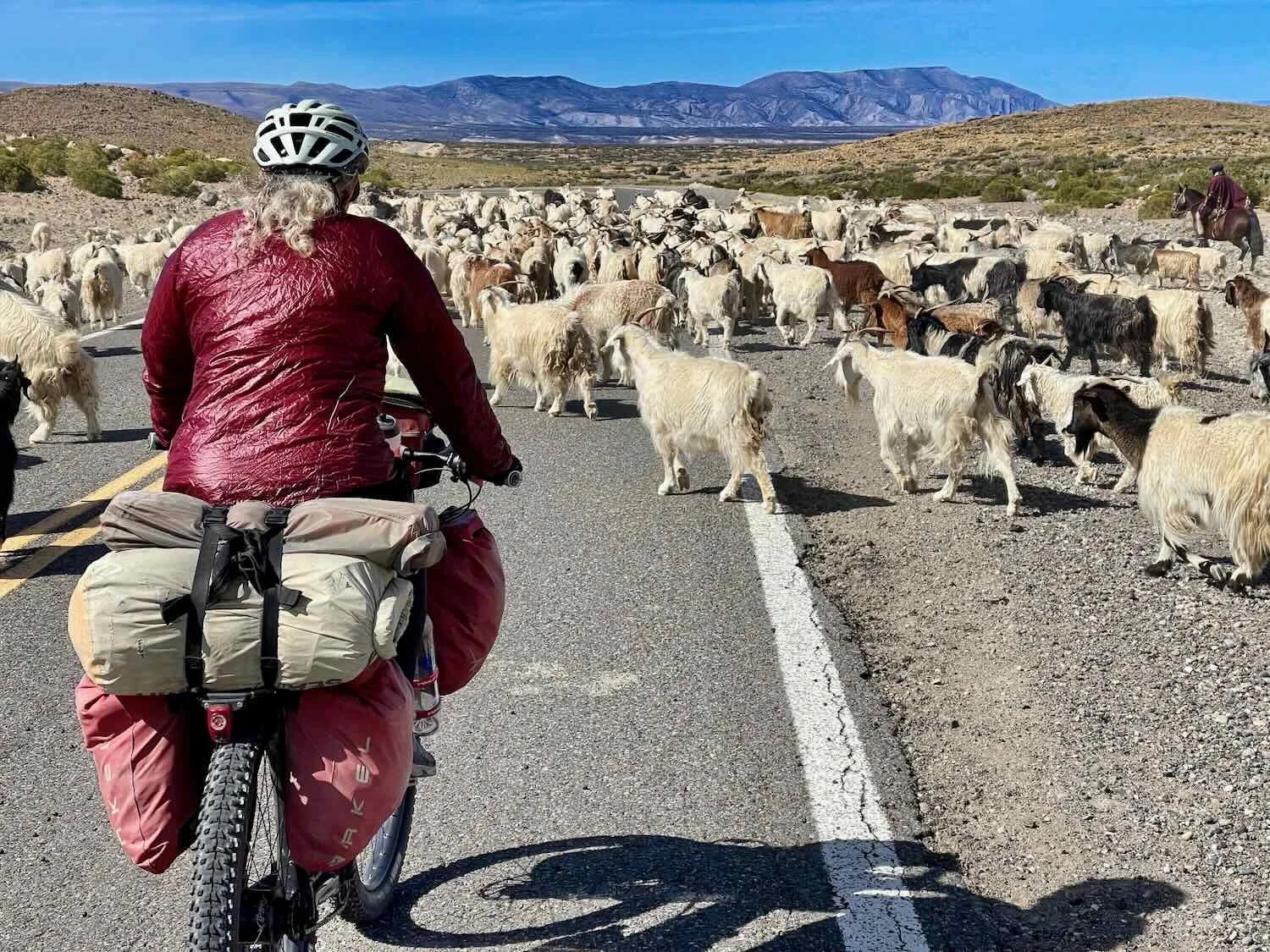
However, the big thing that stood out on the road north of Chos Malal was the livestock. Several times we encountered gauchos herding horses, cattle and/or goats right along the roadway. With the scarcity of forage for their animals in this region, the ranchers move their animals seasonally among distant pastures. Since there isn’t much traffic on the big highway, they take the path of least resistance and just drive their animals down the road for what appeared to be many miles. The people in cars were very tolerant of the disruption, and the animals didn’t seem too bothered by the cars.
A gaucho herded his horses along the highway. Route 40, Near La Salada, Neuquén, Argentina. Copyright © 2019-2025 Pedals and Puffins.
We also shared the road with large herds of goats. Route 40, East of La Salada, Neuquén, Argentina. Copyright © 2019-2025 Pedals and Puffins.
This elaborate gate marked the entrance to a homestead, tucked back among the poplars in the distance. Fancy gates were not as common here as in some countries, but every so often we would pass one. Route 40, East of La Salada, Neuquén, Argentina. Copyright © 2019-2025 Pedals and Puffins.
In a high basin we passed a large, dry, salt-encrusted lake bed. Too bad it didn’t have water when we passed. It looked like it would have been great for flamingos. Route 40, Laguna Auquinco, Neuquén, Argentina. Copyright © 2019-2025 Pedals and Puffins.
As we approached a salt-encrusted, dry lakebed we saw another cyclist coming towards us. He was the first cyclist we had seen in days, so we stopped to say, hello. Beto was from Chos Malal, Argentina and he was out on a relatively short, three day circuit ride. Even though his ride wasn’t that long, he was carrying a surprising amount of gear. His excuse was that he was camping, and the nights were cold. When we mentioned to him that we weren’t seeing many cyclists, he told us that there are many more bikes out on the road in November and December - when the winds are less and the temperatures warmer. We could very much appreciate that.
A roadside visit with Beto (from Argentina). Route 40, Near Auquinco, Neuquén, Argentina. Copyright © 2019-2025 Pedals and Puffins.
Near the dry lakebed we spotted this immature Variable Hawk. As its name suggests, the plumage on these hawks can vary tremendously. This makes them tricky to identify. However they were quite common, and there weren’t too many other hawk species around. That helped. Route 40, Near Auquinco, Neuquén, Argentina. Copyright © 2019-2025 Pedals and Puffins.
When we arrived at our intended camping place we were unimpressed once again. The site consisted of some bushes around the base of a utility pole that was no more than 100 ft (30 m) from the highway. The bushes weren’t even that tall, and definitely were not big enough to hide our tent. Making matters worse, the wind was blowing from a direction in which the bushes wouldn’t provide any protection. We needed to find an alternative.
Fortunately there was a dirt road leading away from the highway right at that point. We decided to take the dirt road and see what we could find, because we hadn’t seen any other options along the highway, and at least we might be able to put some distance between ourselves and the main road.
The dirt road turned out to be a maintenance road for a gas pipeline. Before long we found a lovely spot behind a hill, completely hidden from the road. We thought it was perfect until we tried to pitch the tent. Unfortunately, when we tried to drive the first stake into the ground, we discovered that there was solid bedrock less than an inch below the surface. Our tent is not free-standing (we have to use the stakes), so that was a deal-killer. We had to pick up everything and find another spot.
But another hour of searching yielded nothing better. Finally, we resigned ourselves to going back and camping near the bushes, beside the highway. It wasn’t great, but at least it was reasonably flat.
Then our luck turned. On the way back towards the road PedalingGuy spotted another potential site, up on the side of a hill. The hill would provide some shelter from the wind. And given that there were some rodent burrows in the area, we suspected there was soil deep enough for tent stakes. The deal was sealed when we tried driving in a tent stake, and it went into the ground easily. We pitched the tent in the late evening, using extra guy lines for protection from the wind (having learned our lesson the hard way in the storm at La Amarga). But to be honest, the wind died down a lot that evening, and we just had a gentle breeze.
Our campsite on a hillside, in the fading light. Route 40, East of Auquinco, Neuquén, Argentina. Copyright © 2019-2025 Pedals and Puffins.
The good news is that it didn’t get nearly as cold as we expected that night up on the plateau. After an initial, drastic drop in temperature at sunset that had us scrambling to put on layers, it didn’t seem to get a whole lot colder over night.
More Scenery, More Wildlife
The final run into the town of Buta Ranquil began with a very long downhill off the plateau, landing us among rocky canyons and arroyos that reminded us of Utah or western Colorado. The extra topography created by the canyons was more interesting than the softly rounded mountains of the past few days. We enjoyed the change of scenery, which felt much more visually engaging.
A strikingly bright, ivory-colored layer of rock looked like a vein of volcanic tuff - rock that formed from volcanic ash that fell millions of years ago. Route 40, East of Auquinco, Neuquén, Argentina. Copyright © 2019-2025 Pedals and Puffins.
We encountered even more gauchos driving their goats (and in this case, a few horses) along the road. Route 40, South of Buta Ranquil, Neuquén, Argentina. Copyright © 2019-2025 Pedals and Puffins.
Along the route we saw these amazing, wavy rock formations. It looked like the layers of rock had been tipped up vertically, then smashed like an accordion into a ruffle of rock. Route 40, South of Buta Ranquil, Neuquén, Argentina. Copyright © 2019-2025 Pedals and Puffins.
The distinctive, pointy profile of the Cerro Chihuido de Tril really stood out. Its hard, volcanic core was surrounded by a sloping skirt of looser debris. Route 40, South of Buta Ranquil, Neuquén, Argentina. Copyright © 2019-2025 Pedals and Puffins.
Among the canyons, we even started to see more wildlife. Aside from the occasional hawk, animals had been nearly absent (or at least invisible) along our route for many days. But as we approached Buta Ranquil, we encountered a surprising variety of creatures. One of the most impressive was a very, very long, thin snake. It was at least 6 ft long (1.8 m), probably longer. PedalingGuy followed the snake for almost 10 minutes, trying to get a photo that would reflect just how long the snake really was. To give you some idea, when we first spotted it, the snake was crossing the road and stretched almost completely across one lane of traffic from the side of the road to the midline. Other fun observations included some new birds, and a Southern Mountain Cavy - a little rodent closely related to capybaras, but a whole lot smaller (only about 8 inches long).
A closeup portrait of the mousehole snake. The species is endemic to Argentina. Although they are mildly venomous, the poison is weak and not considered particularly dangerous to humans. Route 40, South of Buta Ranquil, Neuquén, Argentina. Copyright © 2019-2025 Pedals and Puffins.


One of the small canyons our route crossed over on the way to Buta Ranquil. Route 40, South of Buta Ranquil, Neuquén, Argentina. Copyright © 2019-2025 Pedals and Puffins.
We arrived at the hotel in Buta Ranquil (pop. 2,500) in the early afternoon, which ended up creating a few headaches. No one was at the property, so we had to handle the check-in via WhatsApp. We were pretty excited when the owner told us that the back door (emergency exit) was unlocked, and we could let ourselves in. It looked like things were going to be easy.
Not so fast. To spare you all the details, we’ll cut to the chase. The room we were first assigned had problems, so we tried to change to another room. But the three other rooms that were on the quiet side of the hotel (a bar was playing very loud music on the other side when we arrived) had even bigger problems (e.g., a broken bed, no water). After considerable back and forth via WhatsApp with the owner, we ended up just staying in the room we were originally assigned. On the bright side, the owner later gave us a discount, which made it all more agreeable. Since our legs were tired from battling the hills and wind, we even decided to stay a second night.
There wasn’t a lot going on in Buta Ranquil, but it proved to be a relaxing place to spend an extra day.
The town didn’t have much in the way of tourist attractions, but the picturesque Ranqui Church stood on a corner near the main plaza. Route 40, Buta Ranquil, Neuquén, Argentina. Copyright © 2019-2025 Pedals and Puffins.
At The Edge of Patagonia
In Buta Ranquil, we had come to the northern edge of Patagonia. Within a day’s ride we would cross into a new region of Argentina, best known as the cradle of the country’s world-famous wine industry. Incongruously, as the landscape would become drier, agriculture would explode - fed by an abundant supply of mountain snowmelt flowing down from some of the highest mountains in the Andes. While the changes might not be obvious at first, ranches would slowly give way to vineyards and fruit orchards. However, there would continue to be wide expanses of wild places along our route. It promised to be a continuing adventure, served with a glass of wine.